Category:Maingasse 4 (Untertheres)
Jump to navigation
Jump to search
This is the category of the Bavarian Baudenkmal (cultural heritage monument) with the ID D-6-74-180-52 (Wikidata)
|
| Object location | | View all coordinates using: OpenStreetMap |
|---|
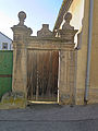
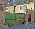
Deutsch: Wohnhaus. eingeschossiger und giebelständiger Mansardhalbwalmdachbau, mit geohrten Fensterrahmen, 18. Jahrhundert. Hofportal. gebänderte Pfeiler mit Vorlagen und Aufsätzen, Sandstein, frühklassizistisch, bezeichnet 1787. Maingasse 4, Untertheres, Gemeinde Theres, Landkreis Haßberge, Unterfranken, Deutschland]].
cultural heritage monument D-6-74-180-52 (0) in Theres, Bavaria  | |||||
| Upload media | |||||
| Instance of | |||||
|---|---|---|---|---|---|
| Location | Theres, Haßberge, Lower Franconia, Bavaria, Germany | ||||
| Street address |
| ||||
| Has part(s) |
| ||||
| Heritage designation | |||||
 | |||||
Media in category "Maingasse 4 (Untertheres)"
The following 3 files are in this category, out of 3 total.
-
 D-6-74-180-52 Hoftor Detail.JPG 3,000 × 4,000; 2.19 MB
-
 D-6-74-180-52 Hoftor.jpg 2,124 × 1,764; 969 KB
-
 D-6-74-180-52 Wohnhaus.JPG 3,788 × 2,920; 1.91 MB

