Category:Maliestraat 11, The Hague
Jump to navigation
Jump to search
| Object location | | View all coordinates using: OpenStreetMap |
|---|
 | |||||
| Upload media | |||||
| Instance of |
| ||||
|---|---|---|---|---|---|
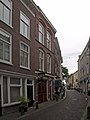
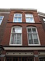
| Location | The Hague, South Holland, Netherlands | ||||
| Street address |
| ||||
| Located on street | |||||
| Heritage designation |
| ||||
 | |||||
|
This is a category about rijksmonument number 17751
|
| Address |
|
Media in category "Maliestraat 11, The Hague"
The following 5 files are in this category, out of 5 total.
-
 DenHaag Maliestraat11.jpg 2,736 × 3,648; 4.41 MB
-
 Maliestraat 11 2.jpg 1,944 × 2,592; 1.17 MB
-
 Maliestraat 11 3.jpg 1,944 × 2,592; 1.45 MB
-
 Maliestraat 11.jpg 1,944 × 2,592; 1.36 MB
-
 Voorgevel - 's-Gravenhage - 20089161 - RCE.jpg 804 × 1,200; 187 KB


