Category:Mampong (Ashanti Region)
Vai alla navigazione
Vai alla ricerca
human settlement .jpg) | |||||
| Carica un file multimediale | |||||
| Istanza di | |||||
|---|---|---|---|---|---|
| Luogo | distretto di Sekyere Ovest, regione di Ashanti, Ghana | ||||
| Popolazione |
| ||||
 | |||||
Mampong Municipality is located north -east of Kumasi, the Ashanti Regional capital. It is bounded to the north by Atebubu District in the Brong Ahafo Region, east by Sekyere Central, south by Sekyere South and Ejura-Sekyedumasi to the West. The Municipality covers a total land area of 782km2 with 69 settlements, 58% being rural. Mampong is the capital
POPULATION: The total population of the Municipal is projected at 75, 367 (2000 population census) with Growth rate projected at 1.4%.
The Mampong Municipal District, formerly the Sekyere West District is one of the twenty-seven (27) districts in the Ashanti Region of Ghana.
File nella categoria "Mampong (Ashanti Region)"
Questa categoria contiene 3 file, indicati di seguito, su un totale di 3.
-
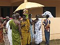 Ashanti chiefs, Mampong, by Erik Kristensen.jpg 2 048 × 1 536; 1,51 MB
-
 Atwea Cliff.jpg 1 200 × 800; 86 KB
-
 The National Archives UK - CO 1069-37-47.jpg 864 × 697; 125 KB


