Category:Marshlink Line
Jump to navigation
Jump to search
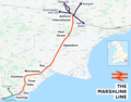
The Marshlink Line is the name given to services on the railway line linking Ashford with Hastings in the South East of England.
railway line in South East England   | |||||
| Upload media | |||||
| Instance of |
| ||||
|---|---|---|---|---|---|
| Part of |
| ||||
| Location | East Sussex, South East England, England | ||||
| Owned by | |||||
| Operator | |||||
| Date of official opening |
| ||||
| Length |
| ||||
| Terminus |
| ||||
| |||||
Subcategories
This category has the following 12 subcategories, out of 12 total.
A
D
- Doleham railway station (10 F)
H
- Ham Street railway station (31 F)
M
- Mount Pleasant Tunnel (5 F)
O
- Ore railway station (16 F)
R
T
- Three Oaks railway station (7 F)
W
- Winchelsea railway station (13 F)
Media in category "Marshlink Line"
The following 12 files are in this category, out of 12 total.
-
 171805Marshlink.jpg 3,722 × 2,792; 3.91 MB
-
 Ashford, Newtown Road Railway Bridge - geograph.org.uk - 1133929.jpg 640 × 426; 86 KB
-

-
 Hastings to Ashford Line - geograph.org.uk - 360652.jpg 479 × 640; 161 KB
-
 Hastings-Ashford Railway - geograph.org.uk - 423857.jpg 479 × 640; 174 KB
-
 Level Crossing - geograph.org.uk - 1525897.jpg 640 × 427; 78 KB
-
 Long Way Home - panoramio.jpg 1,891 × 1,356; 615 KB
-
 Marshlink Line East of Winchelsea Station - geograph.org.uk - 3452139.jpg 4,320 × 3,240; 4.58 MB
-
 Marshlink line.png 2,194 × 1,725; 2.01 MB
-
 Railway Track - geograph.org.uk - 522685.jpg 640 × 480; 128 KB
-
 Train bound for Ashford - geograph.org.uk - 1317049.jpg 640 × 424; 94 KB
-
 Warehorne Level Crossing.jpg 1,366 × 768; 179 KB


