Category:Maryland Route 2
Jump to navigation
Jump to search

 | number: | (two) |
|---|---|---|
| State highways in Maryland: | 2 · 3 · 4 · 5 · 6 · 7 · 8 · 10 · 12 · 14 · 16 · 17 · 18 · 19 · 20 · 21 · 22 |
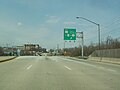
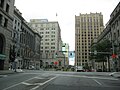
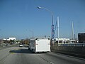
state highway in Maryland, United States _from_the_pedestrian_overpass_just_north_of_East_Conway_Street_in_Baltimore,_Maryland.jpg) MD 2 northbound where it splits from two-way Light Street into northbound-only Calvert Street and southbound-only St. Paul Street  | |||||
| Upload media | |||||
| Instance of | |||||
|---|---|---|---|---|---|
| Location |
| ||||
| Transport network | |||||
| Connects with | |||||
| Owned by | |||||
| Maintained by | |||||
| Has part(s) |
| ||||
| Inception |
| ||||
| Length |
| ||||
| Partially coincident with | |||||
 | |||||
English: Media related to Maryland Route 2, a 79.24-mile (127.52 km) state highway in Calvert and Anne Arundel counties and in the city of Baltimore in Maryland, United States.
Subcategories
This category has the following 4 subcategories, out of 4 total.
Media in category "Maryland Route 2"
The following 200 files are in this category, out of 220 total.
(previous page) (next page)-
 Key Bridge closed sign on MD-2.jpg 2,557 × 1,438; 820 KB
-
 Maryland Route 2 map.png 922 × 574; 73 KB
-
 Maryland State Route 2 (2004).jpg 1,600 × 1,200; 322 KB
-
 Maryland State Route 2 - 14604018170.jpg 3,072 × 2,304; 577 KB
-
 Maryland State Route 2 - 14604035680.jpg 3,072 × 2,304; 761 KB
-
 Maryland State Route 2 - 14604039300.jpg 3,072 × 2,304; 634 KB
-
 Maryland State Route 2 - 14604039700.jpg 3,072 × 2,304; 432 KB
-
 Maryland State Route 2 - 14604048479.jpg 3,072 × 2,304; 559 KB
-
 Maryland State Route 2 - 14604055139.jpg 3,072 × 2,304; 609 KB
-
 Maryland State Route 2 - 14604070119.jpg 3,072 × 2,304; 1,000 KB
-
 Maryland State Route 2 - 14604072439.jpg 3,072 × 2,304; 556 KB
-
 Maryland State Route 2 - 14604089278.jpg 3,072 × 2,304; 532 KB
-
 Maryland State Route 2 - 14604090458.jpg 3,072 × 2,304; 673 KB
-
 Maryland State Route 2 - 14604099028.jpg 3,072 × 2,304; 953 KB
-
 Maryland State Route 2 - 14604101758.jpg 3,072 × 2,304; 937 KB
-
 Maryland State Route 2 - 14604106588.jpg 3,072 × 2,304; 778 KB
-
 Maryland State Route 2 - 14604115628.jpg 3,072 × 2,304; 709 KB
-
 Maryland State Route 2 - 14604116868.jpg 3,072 × 2,304; 711 KB
-
 Maryland State Route 2 - 14604199797.jpg 3,072 × 2,304; 660 KB
-
 Maryland State Route 2 - 14604205657.jpg 3,072 × 2,304; 871 KB
-
 Maryland State Route 2 - 14604224907.jpg 3,072 × 2,304; 480 KB
-
 Maryland State Route 2 - 14604227857.jpg 3,072 × 2,304; 745 KB
-
 Maryland State Route 2 - 14604232087.jpg 3,072 × 2,304; 724 KB
-
 Maryland State Route 2 - 14604234057.jpg 3,072 × 2,304; 919 KB
-
 Maryland State Route 2 - 14767717766.jpg 3,072 × 2,304; 931 KB
-
 Maryland State Route 2 - 14767718986.jpg 3,072 × 2,304; 524 KB
-
 Maryland State Route 2 - 14767720006.jpg 3,072 × 2,304; 598 KB
-
 Maryland State Route 2 - 14767721056.jpg 3,072 × 2,304; 624 KB
-
 Maryland State Route 2 - 14767726516.jpg 3,072 × 2,304; 762 KB
-
 Maryland State Route 2 - 14767729976.jpg 3,072 × 2,304; 719 KB
-
 Maryland State Route 2 - 14767730576.jpg 3,072 × 2,304; 804 KB
-
 Maryland State Route 2 - 14767733336.jpg 3,072 × 2,304; 618 KB
-
 Maryland State Route 2 - 14767737346.jpg 3,072 × 2,304; 928 KB
-
 Maryland State Route 2 - 14767738696.jpg 3,072 × 2,304; 658 KB
-
 Maryland State Route 2 - 14767739006.jpg 3,072 × 2,304; 504 KB
-
 Maryland State Route 2 - 14767747906.jpg 3,072 × 2,304; 936 KB
-
 Maryland State Route 2 - 14767751796.jpg 3,072 × 2,304; 765 KB
-
 Maryland State Route 2 - 14787581491.jpg 3,072 × 2,304; 686 KB
-
 Maryland State Route 2 - 14787587941.jpg 3,072 × 2,304; 946 KB
-
 Maryland State Route 2 - 14787589931.jpg 3,072 × 2,304; 713 KB
-
 Maryland State Route 2 - 14787590641.jpg 3,072 × 2,304; 709 KB
-
 Maryland State Route 2 - 14787612831.jpg 3,072 × 2,304; 713 KB
-
 Maryland State Route 2 - 14787619011.jpg 3,072 × 2,304; 658 KB
-
 Maryland State Route 2 - 14788364124.jpg 3,072 × 2,304; 574 KB
-
 Maryland State Route 2 - 14788379224.jpg 3,072 × 2,304; 1.13 MB
-
 Maryland State Route 2 - 14788385514.jpg 3,072 × 2,304; 662 KB
-
 Maryland State Route 2 - 14788392134.jpg 3,072 × 2,304; 639 KB
-
 Maryland State Route 2 - 14790367552.jpg 3,072 × 2,304; 621 KB
-
 Maryland State Route 2 - 14790372772.jpg 3,072 × 2,304; 712 KB
-
 Maryland State Route 2 - 14790378092.jpg 3,072 × 2,304; 820 KB
-
 Maryland State Route 2 - 14790383762.jpg 3,072 × 2,304; 632 KB
-
 Maryland State Route 2 - 14790393702.jpg 3,072 × 2,304; 579 KB
-
 Maryland State Route 2 - 14790720495.jpg 3,072 × 2,304; 627 KB
-
 Maryland State Route 2 - 14790730425.jpg 3,072 × 2,304; 768 KB
-
 Maryland State Route 2 - 14790743585.jpg 3,072 × 2,304; 757 KB
-
 Maryland State Route 2 - 14790749865.jpg 3,072 × 2,304; 683 KB
-
 Maryland State Route 2 - 14790751715.jpg 3,072 × 2,304; 926 KB
-
 Maryland State Route 2 - 14790753775.jpg 3,072 × 2,304; 550 KB
-
 Maryland State Route 2 - 14810559283.jpg 3,072 × 2,304; 553 KB
-
 Maryland State Route 2 - 14810565263.jpg 3,072 × 2,304; 526 KB
-
 Maryland State Route 2 - 14810569453.jpg 3,072 × 2,304; 1.28 MB
-
 Maryland State Route 2 - 14810571923.jpg 3,072 × 2,304; 712 KB
-
 Maryland State Route 2 - 14810574693.jpg 3,072 × 2,304; 1.07 MB
-
 Maryland State Route 2 - 14810577883.jpg 3,072 × 2,304; 720 KB
-
 Maryland State Route 2 - 14810580703.jpg 3,072 × 2,304; 542 KB
-
 Maryland State Route 2 - 14810581543.jpg 3,072 × 2,304; 827 KB
-
 Maryland State Route 2 - 14810587983.jpg 3,072 × 2,304; 525 KB
-
 Maryland State Route 2 - 4131492173.jpg 1,600 × 1,200; 319 KB
-
 Maryland State Route 2 - 4131493107.jpg 1,600 × 1,200; 324 KB
-
 Maryland State Route 2 - 4131493219.jpg 1,600 × 1,200; 328 KB
-
 Maryland State Route 2 - 4131493535.jpg 1,600 × 1,200; 319 KB
-
 Maryland State Route 2 - 4131493727.jpg 1,600 × 1,200; 321 KB
-
 Maryland State Route 2 - 4131493847.jpg 1,600 × 1,200; 319 KB
-
 Maryland State Route 2 - 4131493953.jpg 1,600 × 1,200; 316 KB
-
 Maryland State Route 2 - 4131494305.jpg 1,600 × 1,200; 315 KB
-
 Maryland State Route 2 - 4131494757.jpg 1,600 × 1,200; 316 KB
-
 Maryland State Route 2 - 4131494885.jpg 1,600 × 1,200; 322 KB
-
 Maryland State Route 2 - 4131494993.jpg 1,600 × 1,200; 319 KB
-
 Maryland State Route 2 - 4131495135.jpg 1,600 × 1,200; 317 KB
-
 Maryland State Route 2 - 4131495605.jpg 1,600 × 1,200; 317 KB
-
 Maryland State Route 2 - 4131495723.jpg 1,600 × 1,200; 313 KB
-
 Maryland State Route 2 - 4131495967.jpg 1,600 × 1,200; 316 KB
-
 Maryland State Route 2 - 4131496183.jpg 1,600 × 1,200; 315 KB
-
 Maryland State Route 2 - 4131496465.jpg 1,600 × 1,200; 319 KB
-
 Maryland State Route 2 - 4131496689.jpg 1,600 × 1,200; 320 KB
-
 Maryland State Route 2 - 4131496781.jpg 1,600 × 1,200; 315 KB
-
 Maryland State Route 2 - 4131497173.jpg 1,600 × 1,200; 319 KB
-
 Maryland State Route 2 - 4131497279.jpg 1,600 × 1,200; 310 KB
-
 Maryland State Route 2 - 4131497941.jpg 1,600 × 1,200; 526 KB
-
 Maryland State Route 2 - 4131498893.jpg 1,600 × 1,200; 502 KB
-
 Maryland State Route 2 - 4131498997.jpg 1,600 × 1,200; 363 KB
-
 Maryland State Route 2 - 4131499139.jpg 1,600 × 1,200; 439 KB
-
 Maryland State Route 2 - 4131499817.jpg 1,600 × 1,200; 777 KB
-
 Maryland State Route 2 - 4131499981.jpg 1,600 × 1,200; 507 KB
-
 Maryland State Route 2 - 4131500299.jpg 1,600 × 1,200; 531 KB
-
 Maryland State Route 2 - 4131500445.jpg 1,600 × 1,200; 428 KB
-
 Maryland State Route 2 - 4131500619.jpg 1,600 × 1,200; 405 KB
-
 Maryland State Route 2 - 4131500745.jpg 1,600 × 1,200; 510 KB
-
 Maryland State Route 2 - 4131500885.jpg 1,600 × 1,200; 419 KB
-
 Maryland State Route 2 - 4131500977.jpg 1,600 × 1,200; 360 KB
-
 Maryland State Route 2 - 4131501141.jpg 1,600 × 1,200; 436 KB
-
 Maryland State Route 2 - 4131501957.jpg 1,600 × 1,200; 349 KB
-
 Maryland State Route 2 - 4131502191.jpg 1,600 × 1,200; 380 KB
-
 Maryland State Route 2 - 4131502337.jpg 1,600 × 1,200; 445 KB
-
 Maryland State Route 2 - 4131502525.jpg 1,600 × 1,200; 551 KB
-
 Maryland State Route 2 - 4131502659.jpg 1,600 × 1,200; 328 KB
-
 Maryland State Route 2 - 4131502793.jpg 1,600 × 1,200; 411 KB
-
 Maryland State Route 2 - 4131502935.jpg 1,600 × 1,200; 451 KB
-
 Maryland State Route 2 - 4131503111.jpg 1,600 × 1,200; 562 KB
-
 Maryland State Route 2 - 4131503437.jpg 1,600 × 1,200; 498 KB
-
 Maryland State Route 2 - 4131503973.jpg 1,600 × 1,200; 479 KB
-
 Maryland State Route 2 - 4131504411.jpg 1,600 × 1,200; 485 KB
-
 Maryland State Route 2 - 4131504755.jpg 1,600 × 1,200; 520 KB
-
 Maryland State Route 2 - 4131505299.jpg 1,600 × 1,200; 470 KB
-
 Maryland State Route 2 - 4132255328.jpg 1,600 × 1,200; 319 KB
-
 Maryland State Route 2 - 4132255448.jpg 1,600 × 1,200; 315 KB
-
 Maryland State Route 2 - 4132255592.jpg 1,600 × 1,200; 314 KB
-
 Maryland State Route 2 - 4132255724.jpg 1,600 × 1,200; 312 KB
-
 Maryland State Route 2 - 4132255796.jpg 1,600 × 1,200; 312 KB
-
 Maryland State Route 2 - 4132256002.jpg 1,600 × 1,200; 310 KB
-
 Maryland State Route 2 - 4132256326.jpg 1,600 × 1,200; 316 KB
-
 Maryland State Route 2 - 4132256452.jpg 1,600 × 1,200; 311 KB
-
 Maryland State Route 2 - 4132257078.jpg 1,600 × 1,200; 316 KB
-
 Maryland State Route 2 - 4132257188.jpg 1,600 × 1,200; 318 KB
-
 Maryland State Route 2 - 4132257410.jpg 1,600 × 1,200; 312 KB
-
 Maryland State Route 2 - 4132257524.jpg 1,600 × 1,200; 312 KB
-
 Maryland State Route 2 - 4132257672.jpg 1,600 × 1,200; 317 KB
-
 Maryland State Route 2 - 4132258180.jpg 1,600 × 1,200; 304 KB
-
 Maryland State Route 2 - 4132258306.jpg 1,600 × 1,200; 318 KB
-
 Maryland State Route 2 - 4132258426.jpg 1,600 × 1,200; 318 KB
-
 Maryland State Route 2 - 4132258728.jpg 1,600 × 1,200; 313 KB
-
 Maryland State Route 2 - 4132258936.jpg 1,600 × 1,200; 321 KB
-
 Maryland State Route 2 - 4132259170.jpg 1,600 × 1,200; 314 KB
-
 Maryland State Route 2 - 4132259260.jpg 1,600 × 1,200; 317 KB
-
 Maryland State Route 2 - 4132259492.jpg 1,600 × 1,200; 314 KB
-
 Maryland State Route 2 - 4132259826.jpg 1,600 × 1,200; 321 KB
-
 Maryland State Route 2 - 4132259936.jpg 1,600 × 1,200; 314 KB
-
 Maryland State Route 2 - 4132260034.jpg 1,600 × 1,200; 314 KB
-
 Maryland State Route 2 - 4132260338.jpg 1,600 × 1,200; 318 KB
-
 Maryland State Route 2 - 4132260440.jpg 1,600 × 1,200; 315 KB
-
 Maryland State Route 2 - 4132260586.jpg 1,600 × 1,200; 316 KB
-
 Maryland State Route 2 - 4132261048.jpg 1,600 × 1,200; 521 KB
-
 Maryland State Route 2 - 4132261206.jpg 1,600 × 1,200; 498 KB
-
 Maryland State Route 2 - 4132261438.jpg 1,600 × 1,200; 691 KB
-
 Maryland State Route 2 - 4132261572.jpg 1,600 × 1,200; 422 KB
-
 Maryland State Route 2 - 4132261702.jpg 1,600 × 1,200; 435 KB
-
 Maryland State Route 2 - 4132262300.jpg 1,600 × 1,200; 468 KB
-
 Maryland State Route 2 - 4132262622.jpg 1,600 × 1,200; 488 KB
-
 Maryland State Route 2 - 4132263144.jpg 1,600 × 1,200; 450 KB
-
 Maryland State Route 2 - 4132264248.jpg 1,600 × 1,200; 410 KB
-
 Maryland State Route 2 - 4132264422.jpg 1,600 × 1,200; 505 KB
-
 Maryland State Route 2 - 4132264564.jpg 1,600 × 1,200; 395 KB
-
 Maryland State Route 2 - 4132264678.jpg 1,600 × 1,200; 343 KB
-
 Maryland State Route 2 - 4132264800.jpg 1,600 × 1,200; 321 KB
-
 Maryland State Route 2 - 4132265048.jpg 1,600 × 1,200; 384 KB
-
 Maryland State Route 2 - 4132266244.jpg 1,600 × 1,200; 572 KB
-
 Maryland State Route 2 - 4132266588.jpg 1,600 × 1,200; 479 KB
-
 Maryland State Route 2 - 4132266760.jpg 1,600 × 1,200; 543 KB
-
 Maryland State Route 2 - 4132267162.jpg 1,600 × 1,200; 638 KB
-
 Maryland State Route 2 - 4132267864.jpg 1,600 × 1,200; 490 KB
-
 Maryland State Route 2 - 4132268054.jpg 1,600 × 1,200; 550 KB
-
 Maryland State Route 2 - 8136663957.jpg 3,072 × 2,304; 567 KB
-
 Maryland State Route 2 - 8136664255.jpg 3,072 × 2,304; 537 KB
-
 Maryland State Route 2 - 8136665309.jpg 3,072 × 2,304; 768 KB
-
 Maryland State Route 2 - 8136665959.jpg 3,072 × 2,304; 536 KB
-
 Maryland State Route 2 - 8136666293.jpg 3,072 × 2,304; 657 KB
-
 Maryland State Route 2 - 8136667023.jpg 3,072 × 2,304; 551 KB
-
 Maryland State Route 2 - 8136667339.jpg 3,072 × 2,304; 544 KB
-
 Maryland State Route 2 - 8136668231.jpg 3,072 × 2,304; 492 KB
-
 Maryland State Route 2 - 8136669083.jpg 3,072 × 2,304; 558 KB
-
 Maryland State Route 2 - 8136669537.jpg 3,072 × 2,304; 470 KB
-
 Maryland State Route 2 - 8136670641.jpg 3,072 × 2,304; 450 KB
-
 Maryland State Route 2 - 8136671483.jpg 3,072 × 2,304; 484 KB
-
 Maryland State Route 2 - 8136672151.jpg 3,072 × 2,304; 782 KB
-
 Maryland State Route 2 - 8136672519.jpg 3,072 × 2,304; 584 KB
-
 Maryland State Route 2 - 8136672913.jpg 3,072 × 2,304; 804 KB
-
 Maryland State Route 2 - 8136674227.jpg 3,072 × 2,304; 649 KB
-
 Maryland State Route 2 - 8136674555.jpg 3,072 × 2,304; 766 KB
-
 Maryland State Route 2 - 8136675075.jpg 3,072 × 2,304; 694 KB
-
 Maryland State Route 2 - 8136675869.jpg 3,072 × 2,304; 871 KB
-
 Maryland State Route 2 - 8136676267.jpg 3,072 × 2,304; 883 KB
-
 Maryland State Route 2 - 8136677513.jpg 3,072 × 2,304; 774 KB
-
 Maryland State Route 2 - 8136677767.jpg 3,072 × 2,304; 538 KB
-
 Maryland State Route 2 - 8136678613.jpg 3,072 × 2,304; 434 KB
-
 Maryland State Route 2 - 8136680397.jpg 3,072 × 2,304; 441 KB
-
 Maryland State Route 2 - 8136680779.jpg 3,072 × 2,304; 510 KB
-
 Maryland State Route 2 - 8136681059.jpg 3,072 × 2,304; 613 KB
-
 Maryland State Route 2 - 8136681263.jpg 3,072 × 2,304; 408 KB
-
 Maryland State Route 2 - 8136681491.jpg 3,072 × 2,304; 513 KB
-
 Maryland State Route 2 - 8136681701.jpg 3,072 × 2,304; 340 KB
-
 Maryland State Route 2 - 8136693608.jpg 3,072 × 2,304; 728 KB
-
 Maryland State Route 2 - 8136693940.jpg 3,072 × 2,304; 566 KB
-
 Maryland State Route 2 - 8136694858.jpg 3,072 × 2,304; 668 KB
-
 Maryland State Route 2 - 8136695128.jpg 3,072 × 2,304; 581 KB
-
 Maryland State Route 2 - 8136695934.jpg 3,072 × 2,304; 566 KB
-
 Maryland State Route 2 - 8136697020.jpg 3,072 × 2,304; 545 KB
-
 Maryland State Route 2 - 8136697870.jpg 3,072 × 2,304; 527 KB
-
 Maryland State Route 2 - 8136698178.jpg 3,072 × 2,304; 480 KB
-
 Maryland State Route 2 - 8136698750.jpg 3,072 × 2,304; 535 KB
-
 Maryland State Route 2 - 8136699018.jpg 3,072 × 2,304; 487 KB

.jpg)


