Category:Mashike, Hokkaido
Vai alla navigazione
Vai alla ricerca

日本語: 増毛町
English: Mashike, Hokkaido
town in Mashike district, Hokkaidō, Japan     | |||||
| Carica un file multimediale | |||||
| Istanza di | |||||
|---|---|---|---|---|---|
| Luogo |
| ||||
| Forma giuridica |
| ||||
| Data di fondazione o creazione |
| ||||
| Popolazione |
| ||||
| Superficie |
| ||||
| sito web ufficiale | |||||
 | |||||
Sottocategorie
Questa categoria contiene le 7 sottocategorie indicate di seguito, su un totale di 7.
M
- Mashike Mountain Trail (4 F)
N
S
- Schools in Mashike, Hokkaido (10 F)
- Mount Shokanbetsu (9 F)
- Shrines in Mashike, Hokkaido (5 F)
T
File nella categoria "Mashike, Hokkaido"
Questa categoria contiene 45 file, indicati di seguito, su un totale di 45.
-
 Bekkari Fishing Port.jpg 4 320 × 3 240; 2,05 MB
-
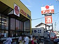 Chuo Supermarket Mashike.jpg 3 072 × 2 304; 3,4 MB
-
 Emblem of Mashike, Hokkaido (1934–1972).svg 512 × 503; 3 KB
-
 Emblem of Mashike, Hokkaido.svg 512 × 506; 4 KB
-
 EnganBus Masike terminal.JPG 3 648 × 2 736; 3,85 MB
-
 Flag of Mashike Hokkaido.png 650 × 388; 8 KB
-
 Flag of Mashike, Hokkaido.svg 500 × 333; 6 KB
-
 Former Mashike Hokkaido chapter.png 284 × 279; 6 KB
-
 Hokkaido Mashike-town.png 300 × 152; 14 KB
-
 Hokkaido Prefectural Road 94 at Afun.jpg 4 320 × 3 240; 1,95 MB
-
 JR hokkaido Mashike norokko train.JPG 1 536 × 1 024; 1,27 MB
-
 Kunimare Brewing scientific library.JPG 1 536 × 1 024; 1,31 MB
-
 Kunimare Brewing.JPG 1 536 × 1 024; 872 KB
-
 Mashike 20130828 095537.jpg 2 448 × 1 836; 2,59 MB
-
 Mashike heliport aerial photograph.jpg 1 040 × 780; 647 KB
-
 Mashike Hokkaido chapter.JPG 265 × 262; 27 KB
-
 Mashike in Hokkaido Prefecture Ja.svg 800 × 872; 46 KB
-
 Mashike in Rumoi Subprefecture.gif 616 × 816; 50 KB
-
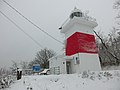 Mashike lighthouse 2015.jpg 2 560 × 1 920; 1,11 MB
-
 Mashike lighthouse.JPG 1 024 × 1 536; 879 KB
-
 Mashike Riverside Park - panoramio.jpg 3 264 × 2 448; 2,43 MB
-
 Mashike Riverside Park.jpg 3 264 × 2 448; 3,53 MB
-
 Mashike terminal.jpg 1 024 × 768; 105 KB
-
 Mashike town center area Aerial photograph.1977.jpg 7 336 × 3 257; 16,25 MB
-
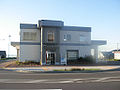
 Mashike Town Tourist Information Office.jpg 4 320 × 3 240; 2,38 MB
-
 Mashike Trailhead of Mashike Mountain Road.jpg 4 320 × 3 240; 5,15 MB
-
 Motojin-ya of Mashike.jpg 4 320 × 3 240; 2,54 MB
-
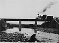 Nobusha railroad bridge in 1921.jpg 1 631 × 1 173; 364 KB
-
 Obetsukari 20201006084815 (50887068753).jpg 4 032 × 3 024; 2,95 MB
-
 Obetsukari 20201006085858 (50887900852).jpg 4 032 × 3 024; 3,7 MB
-
 Obetsukari 20201006092704 (50887066608).jpg 4 032 × 3 024; 3,75 MB
-
 Obetsukari 20201006094444 (50887066018).jpg 4 032 × 3 024; 4,34 MB
-
 Obetsukari 20201006094604 (50887781836).jpg 4 032 × 3 024; 2,92 MB
-
 Obetsukari 20201006095357 (50887064528).jpg 4 032 × 3 024; 3,17 MB
-
 Ofuyu 20201006114801 (50856998077).jpg 4 032 × 3 024; 2,97 MB
-
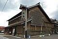
 Old Homma family residence.JPG 1 536 × 1 024; 980 KB
-
 Population distribution of Mashike, Hokkaido, Japan.svg 512 × 256; 22 KB
-
 Shokan Kaigan.jpg 1 280 × 960; 411 KB
-
 Town Hall of Mashike, Hokkaido, Japan.jpg 3 776 × 2 520; 5,1 MB
-
 北海道道301号線.jpg 3 648 × 2 432; 2,82 MB
-
 基礎自治体位置図 01481.svg 400 × 604; 13 KB
-
 増毛 Mashike (2940572618).jpg 2 048 × 1 536; 1,07 MB
-
 大別苅トンネル - panoramio.jpg 1 600 × 900; 316 KB
-
 紅嶺橋 - panoramio.jpg 1 600 × 900; 257 KB
-
 風待食堂.jpg 320 × 240; 24 KB


.svg)


.jpg)
.jpg)
.jpg)
.jpg)
.jpg)
.jpg)
.jpg)


.jpg)


