Category:Mauritsweg 51 (Rotterdam)
Jump to navigation
Jump to search
| Object location | | View all coordinates using: OpenStreetMap |
|---|
 | |||||
| Upload media | |||||
| Instance of | |||||
|---|---|---|---|---|---|
| Location | Rotterdam, South Holland, Netherlands | ||||
| Street address |
| ||||
| Located on street | |||||
| Heritage designation |
| ||||
 | |||||
|
This is a category about rijksmonument number 32798
|
| Address |
|
Media in category "Mauritsweg 51 (Rotterdam)"
The following 9 files are in this category, out of 9 total.
-
 Glas-in-lood raam - Rotterdam - 20192267 - RCE.jpg 1,190 × 1,200; 243 KB
-
 Hoger, voorgevels overzicht - Rotterdam - 20192260 - RCE.jpg 1,200 × 803; 228 KB
-
 Overzicht voorzijde - Rotterdam - 20192261 - RCE.jpg 1,195 × 1,200; 360 KB
-
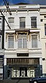 Rotterdam mauritsweg51.jpg 1,206 × 2,200; 337 KB
-
 Snijwerk boven deur - Rotterdam - 20192263 - RCE.jpg 1,185 × 1,200; 161 KB
-
 Snijwerk boven deur - Rotterdam - 20192264 - RCE.jpg 1,188 × 1,200; 205 KB
-
 Snijwerk boven deur - Rotterdam - 20192265 - RCE.jpg 1,192 × 1,200; 168 KB
-
 Snijwerk boven deur - Rotterdam - 20192266 - RCE.jpg 1,190 × 1,200; 157 KB
-
 Stucwerk bij trap - Rotterdam - 20192262 - RCE.jpg 1,192 × 1,200; 214 KB


