Category:Meall an t-Suidhe
Vai alla navigazione
Vai alla ricerca
|
Meall an t-Suidhe è presente su OpenStreetMap (mostra). |
mountain in Highland, Scotland, UK  | |||||
| Carica un file multimediale | |||||
| Istanza di | |||||
|---|---|---|---|---|---|
| Luogo | Highland, Highlands, Scozia | ||||
| Altezza sul mare |
| ||||
 | |||||
Meall an t-Suidhe is a summit rising between Fort William and the Ben Nevis.
File nella categoria "Meall an t-Suidhe"
Questa categoria contiene 15 file, indicati di seguito, su un totale di 15.
-
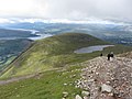 Ben Nevis path and view of Lochan Meall an t-Suidhe - geograph.org.uk - 3071860.jpg 4 000 × 3 000; 3,14 MB
-
 Field by Errocht - geograph.org.uk - 1469681.jpg 640 × 480; 58 KB
-

-
-
 Meall an t-Suidhe and Lochan Meall an t-Suidhe from the Ben Nevis footpath.png 4 524 × 2 545; 15,44 MB
-
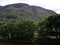
 Meall an t-Suidhe from Auchitee road - geograph.org.uk - 992863.jpg 640 × 480; 60 KB
-
 Meall an t-Suidhe from Claggan.png 3 836 × 2 317; 8,27 MB
-

-
 Meall an t-Suidhe N ridge.png 3 000 × 4 000; 25,34 MB
-
 Meall an t-Suidhe summit cairn 711m - geograph.org.uk - 245449.jpg 640 × 366; 41 KB
-
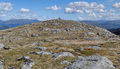 Meall an t-Suidhe summit.png 3 985 × 2 277; 12,9 MB
-
 Meall an t-Suidhe view on Loch Linnhe and Loch Eil.png 3 985 × 2 076; 13,77 MB
-
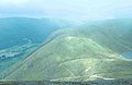
 Meall an t-Suidhe view on the Ben Nevis.png 3 928 × 2 075; 9,53 MB
-
-
 Meall an t-Suidhe at Sunset - geograph.org.uk - 492985.jpg 640 × 357; 419 KB


