Category:Meall nan Aighean (Càrn Mairg Group)
Jump to navigation
Jump to search
981m high mountain near Fortingall, Perth and Kinross, Scotland, UK  | |||||
| Upload media | |||||
| Instance of | |||||
|---|---|---|---|---|---|
| Location | Perth and Kinross, Scotland | ||||
| Mountain range | |||||
| Topographic prominence |
| ||||
| Elevation above sea level |
| ||||
 | |||||
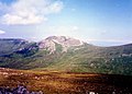
Meall nan Aighean (or Meall na Aighean) is a mountain located 22 km west of Aberfeldy in the Perth and Kinross council area of Scotland. It stands on the northern side of Glen Lyon in a cluster of four Munros known as the Càrn Mairg group which are situated in a semi circle around the Invervar Burn. It is 981 m high, and listed as a Munro.
Media in category "Meall nan Aighean (Càrn Mairg Group)"
The following 6 files are in this category, out of 6 total.
-
 Carn Mairg from Meall nan Aighean.jpg 1,986 × 1,422; 270 KB
-
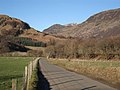 Entrance to Glen Lyon - geograph.org.uk - 328041.jpg 640 × 480; 86 KB
-
 Meal na Aighean - geograph.org.uk - 872409.jpg 640 × 390; 55 KB
-
 Meall nan Aighean , Munro No 169 - geograph.org.uk - 222371.jpg 640 × 480; 113 KB
-
 On Bolfracks Hill - geograph.org.uk - 1130494.jpg 640 × 427; 131 KB
-
 The summit of Meall nan Aighean - geograph.org.uk - 88000.jpg 640 × 461; 102 KB


