Category:Menhir de la Vacherie
Jump to navigation
Jump to search
| Object location | | View all coordinates using: OpenStreetMap |
|---|
|
This building is classé au titre des monuments historiques de la France. It is indexed in the base Mérimée, a database of architectural heritage maintained by the French Ministry of Culture, under the reference PA00108611
|
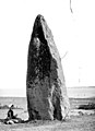
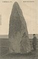
standing stone in Donges, France  | |||||
| Upload media | |||||
| Instance of | |||||
|---|---|---|---|---|---|
| Location | Donges, canton of Montoir-de-Bretagne, Loire-Atlantique, Pays de la Loire, Metropolitan France, France | ||||
| Heritage designation |
| ||||
 | |||||
Media in category "Menhir de la Vacherie"
The following 2 files are in this category, out of 2 total.
-
 44 Donges Le Menhir 2.jpg 802 × 1,258; 207 KB
-