Category:Menstraat 11, Deventer
Jump to navigation
Jump to search
| Object location | | View all coordinates using: OpenStreetMap |
|---|
 | |||||
| Upload media | |||||
| Instance of |
| ||||
|---|---|---|---|---|---|
| Location | Deventer, Overijssel, Netherlands | ||||
| Street address |
| ||||
| Located on street | |||||
| Heritage designation |
| ||||
 | |||||
|
This is a category about rijksmonument number 12667
|
| Address |
|
Media in category "Menstraat 11, Deventer"
The following 6 files are in this category, out of 6 total.
-
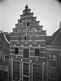
 Bergschild- Menstraat - Deventer - 20053934 - RCE.jpg 1,195 × 1,200; 317 KB
-
 Deventer, Netherlands - panoramio (55).jpg 1,155 × 2,048; 545 KB
-
 Gevel - Deventer - 20056035 - RCE.jpg 882 × 1,200; 232 KB
-
 Gevels - Deventer - 20056034 - RCE.jpg 808 × 1,200; 182 KB
-
 Menstraat 11 Deventer.jpg 1,712 × 2,560; 1.59 MB
-
 Voorgevel - Deventer - 20056038 - RCE.jpg 894 × 1,200; 174 KB

.jpg)


