Category:Merian plan of Paris
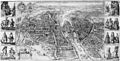
The Merian plan of Paris was created in 1615 and presents a perspective view looking to the east with a scale of about 1 to 7,000. It originally consisted of two engraved plates 50 x 37 cm each comprising the left and right halves of the map and was printed with 2 columns of portraits (each 50 x 13 cm) on the left and right sides of the respective map halves. The entire assembly was 50 x 101.5 cm. The Merian map was frequently used as the basis of subsequent maps, including those of Visscher (1618), Melchior Tavernier (ca. 1625–1635), Jacob van der Heyden (1630), Christophe Tassin (1634), Dubarle (ca. 1641), Giacomo Lauro (ca. 1642), and Martin Zeiler (1655). In turn, the map of Tassin served as the source of numerous later maps.
Sources[edit]
- Boutier, Jean (2007). Les Plans de Paris, second edition, pp. 120–122. Paris: Bibliothèque nationale de France. ISBN 9782717723892.
print by Matthäus Merian  | |||||
| Upload media | |||||
| Instance of | |||||
|---|---|---|---|---|---|
| Main subject | |||||
| Depicts | Paris | ||||
| Creator | |||||
| Inception |
| ||||
| |||||
Subcategories
This category has the following 2 subcategories, out of 2 total.
Media in category "Merian plan of Paris"
The following 18 files are in this category, out of 18 total.
-
 Atlas des anciens plans de Paris - 056. Paris en 1615 - David Rumsey.jpg 24,757 × 17,385; 117.75 MB
-
 Atlas des anciens plans de Paris - Paris en 1615 - BHVP.jpg 4,834 × 3,312; 5.09 MB
-
 Atlas des anciens plans de Paris - Paris en 1615 - David Rumsey.jpg 18,400 × 12,700; 168.15 MB
-
 Mathäus Merian, Le plan de la ville cité université et fauxbourgs de Paris 1 - Paris Musées.jpg 12,576 × 6,992; 71.25 MB
-
 Mathäus Merian, Le plan de la ville cité université et fauxbourgs de Paris 2 - Paris Musées.jpg 12,570 × 6,977; 71.39 MB
-
 Mathäus Merian, Plan de Paris sous Louis XIII, par Mathieu Mérian. 1615 - Paris Musées.jpg 12,696 × 7,760; 78.95 MB
-
 Matthäus Merian, Le Plan de la ville, cité et fauxbourgs de Paris, 1615 (text) - BHVP.jpg 7,485 × 2,918; 6.54 MB
-
 Matthäus Merian, Le Plan de la ville, cité et fauxbourgs de Paris, 1615 - BHVP.jpg 5,976 × 3,038; 5.02 MB
-

-

-
 Matthäus Merian, Le plan de la ville, cité, université et fauxbourgs de Paris - Gallica.jpg 12,230 × 8,176; 59.68 MB
-
 Merian map of Paris 1615 - Boutier 2007 p121.jpg 1,680 × 848; 395 KB
-
 Merian map of Paris 1615 - Gallica.jpg 11,967 × 7,897; 20.96 MB
-
 Paul Dujardin, Paris en 1615 - Fac-similé du plan de Mathier Mérian - Paris Musées.jpg 12,352 × 8,632; 79.41 MB
-
 Plan de Mérian.jpg 3,150 × 2,101; 8.08 MB
-
 Plan de Paris de Mérian.jpg 4,000 × 2,668; 2.02 MB
-
 Plan de Paris par Merian - 1615.jpg 5,133 × 3,437; 6.33 MB
-
 Plan de Paris sous Louis XIII by Matthäus Merian, 1615 - Gallica.jpg 12,796 × 7,303; 47.83 MB


_-_Gallica.jpg)
_-_Gallica.jpg)


_-_BHVP.jpg)