Category:Mieminger Gebirge
Vai alla navigazione
Vai alla ricerca
gruppo montuoso delle Alpi Calcaree Nordtirolesi in Austria   | |||||
| Carica un file multimediale | |||||
| Istanza di | |||||
|---|---|---|---|---|---|
| Luogo | Tirolo, Austria | ||||
| Catena montuosa | |||||
| Punto più alto | |||||
| Altezza sul mare |
| ||||
 | |||||
Sottocategorie
Questa categoria contiene le 21 sottocategorie indicate di seguito, su un totale di 21.
D
G
- Gschwandtkopf (17 F)
H
- Hinterer Tajakopf (6 F)
- Hochplattig (10 F)
- Hochwand (18 F)
I
- Igelskopf (2 F)
K
- Karkopf (Mieminger Gebirge) (8 F)
S
- Schartenkopf (Biberwier) (6 F)
- Ehrwalder Sonnenspitze (58 F)
T
- Tschirgant (48 F)
V
- Vorderer Drachenkopf (7 F)
- Vorderer Tajakopf (12 F)
W
- Wamperter Schrofen (8 F)
- Wankspitze (4 F)
- Wannig (12 F)
File nella categoria "Mieminger Gebirge"
Questa categoria contiene 102 file, indicati di seguito, su un totale di 102.
-
 2012-06-02 Blick von der Terrasse der Hochthörlehütte - panoramio.jpg 2 816 × 2 112; 4,95 MB
-
 Achbergzug.png 1 478 × 850; 1,84 MB
-
 Alpen 0005 by Ayhan Arfat.jpg 2 428 × 1 473; 2,35 MB
-
 Aussichtsturm am Grünberg.jpg 3 391 × 4 521; 9,77 MB
-
 Autriche-Abbaye de Stams-Monastère-19920804.jpg 3 032 × 1 927; 6,46 MB
-
 Bergdoktorhaus.jpg 1 536 × 1 024; 375 KB
-
 Berge 2.JPG 1 600 × 903; 237 KB
-
 Biberwier, Austria - panoramio.jpg 1 410 × 831; 1,44 MB
-
 Birgitz 06.jpg 3 648 × 2 736; 3,32 MB
-
 Birgitz-gegen-Inntal-Mieminger-Kette-und-Zugspitze.jpg 1 865 × 1 315; 634 KB
-
 Blindsee mit Mieminger und Zugspitze vom Fernpass von W.jpg 3 264 × 2 100; 3,52 MB
-
 Breitenkopfhuette.jpg 1 208 × 1 600; 817 KB
-
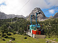 Cable lift.jpg 3 960 × 2 910; 1,51 MB
-
 Carl Reiser Im Mieminger Gebirge (Tirol).jpg 1 200 × 845; 1,11 MB
-
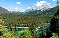
 Drachensee and Mieminger Mountains.jpg 4 000 × 3 000; 5,12 MB
-
 Ehrwald Martinsplatz.jpg 1 276 × 957; 309 KB
-
 Ehrwalder Sonnenspitze (2412 m) .JPG 5 472 × 3 080; 2,56 MB
-
 Feigenstein Wannig.jpg 849 × 662; 390 KB
-
 Flowers in Austria.jpg 500 × 598; 115 KB
-
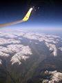
 Flug -Rom-Düsseldorf-Hamburg 2013 by-RaBoe 176.jpg 3 666 × 2 435; 1,39 MB
-
 Flug -Rom-Düsseldorf-Hamburg 2013 by-RaBoe 177.jpg 3 606 × 2 395; 1,14 MB
-
 Flug -Rom-Düsseldorf-Hamburg 2013 by-RaBoe 178.jpg 3 666 × 1 739; 963 KB
-
 Fog on mountain 2.jpg 5 703 × 2 863; 2,91 MB
-
 Fog on mountain 3.jpg 5 671 × 2 415; 2,12 MB
-
 Fog on mountain 4.jpg 6 530 × 2 425; 1,6 MB
-
 Fog on mountain.jpg 6 161 × 2 690; 2,39 MB
-

-

-

-

-
 Gaistal Leutasch02.jpg 3 172 × 1 896; 561 KB
-
 Gaistal Leutascher Ache 1.jpg 1 200 × 674; 395 KB
-
 Gaistal-Panorama01.jpg 5 592 × 2 136; 1,06 MB
-
 Gaistalbach Quellen.jpg 1 080 × 810; 528 KB
-
 Gipfelkreuz Hinterer Tajakopf, 2408m.jpeg 3 648 × 2 736; 2,56 MB
-
 Gipfelkreuz Hinterer Tajakopf.jpeg 3 648 × 2 736; 2,57 MB
-
 Griesspitz-Grat in the evening.jpg 4 000 × 3 000; 4,77 MB
-
 Grubig-Ost-Pano.jpg 8 192 × 1 856; 4,23 MB
-
 Götzens-paesaggio 03.jpg 3 648 × 2 736; 3,24 MB
-
 Hermannstollen Max Dudek 1900.jpg 653 × 653; 331 KB
-
 Hochplattig N.JPG 3 800 × 2 440; 5,58 MB
-
 Igelsee 1.jpg 1 080 × 810; 319 KB
-
 Igelsee 2.jpg 1 200 × 674; 332 KB
-
 Inntal Mieminger Wetterstein02.jpg 3 920 × 1 532; 398 KB
-
 Lehnberghaus.JPG 3 072 × 2 048; 1,89 MB
-
 Litnisschrofen Westridge02.JPG 3 264 × 2 448; 3,31 MB
-
 Luftbild Alpen 02 (RaBoe).jpg 750 × 1 000; 579 KB
-
 Luftbild Alpen 03 (RaBoe).jpg 750 × 1 000; 610 KB
-
 Luftbild Alpen 04 (RaBoe).jpg 1 000 × 750; 669 KB
-
 Luftbild aus 10.000 Meter Höhe vom Wettersteingebirge und der Zugspitze.jpg 4 272 × 2 848; 1,68 MB
-
 Miejscowość Telfs w Tyrolu.JPG 4 928 × 3 264; 2,82 MB
-
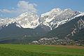
 Mieminger Gebirge Nordansicht.JPG 3 264 × 2 448; 2,93 MB
-
 Mieminger Gebirge.jpg 3 872 × 2 592; 4,09 MB
-
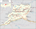
 Mieminger Kette map2.png 3 731 × 2 062; 1,34 MB
-
 Mieminger Kette v d Maria-Opferungskapelle.jpg 16 320 × 7 815; 25,22 MB
-
 Mieminger Kette vom Inntal.jpg 3 456 × 2 304; 3,41 MB
-
 Mieminger Kette.svg 1 343 × 742; 790 KB
-
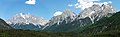
 Mieminger mountain range.jpg 4 000 × 3 000; 4,78 MB
-
 Mieminger Plateau SE.JPG 3 449 × 2 161; 6,08 MB
-
 Mieminger und Zugspitz Panorama von W vom Fernpass.jpg 6 534 × 2 005; 5,34 MB
-
 Mittelstation Patscherkofelbahn.jpg 5 626 × 3 761; 7,71 MB
-
 Mittersee 2.jpg 4 032 × 3 024; 3,7 MB
-
 Mountain panorama.jpg 7 992 × 2 572; 3,86 MB
-
 Mountain path from Hinterer Tajakopf down to Coburger Hütte.jpg 4 000 × 3 000; 4,53 MB
-
 Oberinntal Austria from E on 2014-10-18.png 5 184 × 1 536; 11,69 MB
-
 Rock erosion valley in Mieminger mountains.jpg 3 000 × 4 000; 4,71 MB
-
 Salfeins gegen Mieminger Gebirge.jpg 6 000 × 4 000; 8,03 MB
-
 Sanktuarium Maryjne w Locherboden Tyrol.jpg 4 928 × 3 264; 7,91 MB
-
 Seeben Alm, Seebensee and Zugspitze.jpg 4 000 × 3 000; 4,82 MB
-
 Seeben Alm.jpg 4 000 × 3 000; 4,95 MB
-
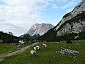 Seebensee Alm with Seebensee, sheeps and Zugspitze.jpg 4 000 × 3 000; 4,98 MB
-
 Seebenwand with Seebenfall and Seeben Via Ferrata.jpg 3 000 × 4 000; 4,73 MB
-
 Seefeld in Tirol Austria from ESE on 2014-10-18.png 10 368 × 3 456; 56,81 MB
-
 Seefeld plateau 01.jpg 3 950 × 1 198; 1,52 MB
-
 Seefeld.jpg 3 456 × 1 944; 1,97 MB
-
 Seefelder Plateau.jpg 4 596 × 2 866; 6,88 MB
-
 Sheep in Austria.jpg 2 222 × 2 580; 1,32 MB
-
 Sheeps eating.jpg 3 672 × 2 832; 3,03 MB
-
 Silberleithe 1989.jpg 768 × 512; 127 KB
-
 Silzer.jpg 640 × 480; 68 KB
-
 Sommerhaus des Stiftes Stams mit Kapelle Mariae Heimsuchung.jpg 2 560 × 1 920; 2,46 MB
-
 Stift Stams - panoramio (3).jpg 4 710 × 3 090; 13,92 MB
-

-
 Tschirgant aus dem Oetztal.jpg 3 378 × 2 271; 3,5 MB
-
 View near Tajakopf.jpg 20 263 × 2 780; 10,4 MB
-
 View on mountain in Austria 3.jpg 4 032 × 3 024; 2,06 MB
-
 View on mountain in Austria.jpg 7 553 × 2 208; 3,23 MB
-
 Wankspitze von SW.JPG 4 608 × 3 456; 9,49 MB
-
 Wanneck bei Lermoos 2.jpg 700 × 483; 58 KB
-
 Wanneck bei Lermoos.JPG 800 × 545; 406 KB
-
 Wannig nassereith.jpg 2 592 × 1 944; 1,52 MB
-
 Wettersteingebirge und Mieminger Kette.png 3 731 × 3 009; 1,98 MB
-
-
 Wiki takes Nordtiroler Oberland 20150605 Mieminger Gebirge 6951.jpg 3 588 × 2 388; 5,15 MB
-
 Wildermieming 6388.jpg 5 184 × 3 456; 16,01 MB
-
 Wildermieming 6390.jpg 5 184 × 3 456; 17,3 MB
-
 Wildermieming.jpg 1 536 × 1 024; 361 KB
-
 Zirl und Nassereith. NYPL1226617.tiff 4 496 × 5 419; 69,71 MB
-
 Zugspitze and Seebensee.jpg 4 000 × 3 000; 4,83 MB
-
 Zugspitze from Hoher Gang.jpg 4 000 × 3 000; 4,66 MB
-
 Zugspitze von Munde HQ.jpg 1 280 × 960; 381 KB
-
 Zugspitze with Seeben-Alm.jpg 4 000 × 3 000; 4,69 MB


.jpg)


_.JPG)


.jpg)
.jpg)
.jpg)


.jpg)


_-_panoramio.jpg)


