Category:Mittelrhein
Jump to navigation
Jump to search
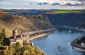
This category should be limited to media where the Rhine river is an essential element, between Bingen (km 525) and Bonn (km 655).
for views inside places near the Rhine (ruins, castles ...), between Bingen and Koblenz.
for views inside places near the Rhine (ruins, castles ...), between Koblenz and Bonn.


landscape of Rhine valley between Nahe mouth and Bonn  | |||||
| Upload media | |||||
| Instance of | |||||
|---|---|---|---|---|---|
| Location | Rhineland-Palatinate, Germany | ||||
| Tributary | |||||
 | |||||
Subcategories
This category has the following 33 subcategories, out of 33 total.
- Mittelrhein-Marathon (3 F)
- Wines of Mittelrhein (6 F)
A
- Rhine in Assmannshausen (64 F)
B
- Binger Loch (48 F)
F
- Rhine in Filsen (5 F)
K
L
M
N
R
- Rhine in Rheindiebach (7 F)
- Rheinlache (7 F)
S
- Steinbruch Trechtingshausen (9 F)
T
- Tal Total (5 F)
- Rhine at Trechtingshausen (18 F)
Media in category "Mittelrhein"
The following 125 files are in this category, out of 125 total.
-
 "St. Nikolaus I".jpg 3,648 × 2,736; 3.38 MB
-

-
 Bacharach am Rhein (19225822135).jpg 15,580 × 4,521; 46.02 MB
-
 Bacharacher Werth, Niedrigwasser Mittelrhein 2022 (53021670912).jpg 3,000 × 1,999; 6.46 MB
-
 Bacharacher Werth, Niedrigwasser Mittelrhein 2022 (53021670937).jpg 3,000 × 1,999; 5.98 MB
-
 Bacharacher Werth, Niedrigwasser Mittelrhein 2022 (53021670952).jpg 3,000 × 1,999; 5.72 MB
-
 Bacharacher Werth, Niedrigwasser Mittelrhein 2022 (53021671072).jpg 3,000 × 1,999; 5.19 MB
-
 Bacharacher Werth, Niedrigwasser Mittelrhein 2022 (53021671147).jpg 3,000 × 1,999; 5.58 MB
-
 Bacharacher Werth, Niedrigwasser Mittelrhein 2022 (53021671222).jpg 3,000 × 1,999; 5.32 MB
-
 Bacharacher Werth, Niedrigwasser Mittelrhein 2022 (53021671262).jpg 3,000 × 1,999; 5.21 MB
-
 Bacharacher Werth, Niedrigwasser Mittelrhein 2022 (53022249881).jpg 3,000 × 1,999; 6.19 MB
-
 Bacharacher Werth, Niedrigwasser Mittelrhein 2022 (53022250006).jpg 3,000 × 1,999; 6.26 MB
-
 Bacharacher Werth, Niedrigwasser Mittelrhein 2022 (53022250051).jpg 3,000 × 1,999; 6.46 MB
-
 Bacharacher Werth, Niedrigwasser Mittelrhein 2022 (53022250076).jpg 3,000 × 1,999; 5.97 MB
-
 Bacharacher Werth, Niedrigwasser Mittelrhein 2022 (53022250111).jpg 3,000 × 1,999; 5.63 MB
-
 Bacharacher Werth, Niedrigwasser Mittelrhein 2022 (53022250226).jpg 3,000 × 1,999; 4.83 MB
-
 Bacharacher Werth, Niedrigwasser Mittelrhein 2022 (53022250271).jpg 3,000 × 1,999; 5.6 MB
-
 Bacharacher Werth, Niedrigwasser Mittelrhein 2022 (53022250306).jpg 3,000 × 1,999; 5.21 MB
-
 Bacharacher Werth, Niedrigwasser Mittelrhein 2022 (53022250346).jpg 3,000 × 1,999; 5.28 MB
-
 Bacharacher Werth, Niedrigwasser Mittelrhein 2022 (53022250356).jpg 3,000 × 1,999; 4.85 MB
-
 Bacharacher Werth, Niedrigwasser Mittelrhein 2022 (53022418889).jpg 3,000 × 1,999; 5.21 MB
-
 Bacharacher Werth, Niedrigwasser Mittelrhein 2022 (53022419099).jpg 3,000 × 1,999; 5.67 MB
-
 Bacharacher Werth, Niedrigwasser Mittelrhein 2022 (53022419224).jpg 3,000 × 1,999; 5.52 MB
-
 Bacharacher Werth, Niedrigwasser Mittelrhein 2022 (53022419274).jpg 3,000 × 1,999; 6.25 MB
-
 Bacharacher Werth, Niedrigwasser Mittelrhein 2022 (53022637875).jpg 3,000 × 1,999; 5.36 MB
-
 Bacharacher Werth, Niedrigwasser Mittelrhein 2022 (53022637940).jpg 3,000 × 1,999; 6.44 MB
-
 Bacharacher Werth, Niedrigwasser Mittelrhein 2022 (53022638170).jpg 3,000 × 1,999; 5.18 MB
-
 Bacharacher Werth, Niedrigwasser Mittelrhein 2022 (53022638175).jpg 3,000 × 1,999; 5.97 MB
-
 Bacharacher Werth, Niedrigwasser Mittelrhein 2022 (53022638185).jpg 3,000 × 1,999; 5.15 MB
-
 Bacharacher Werth, Niedrigwasser Mittelrhein 2022 (53022638220).jpg 3,000 × 1,999; 5.31 MB
-
 Bacharacher Werth, Niedrigwasser Mittelrhein 2022 (53022638255).jpg 3,000 × 1,999; 5.46 MB
-
 Bacharacher Werth, Niedrigwasser Mittelrhein 2022 (53022638400).jpg 3,000 × 1,999; 5.43 MB
-
 Bacharacher Werth, Niedrigwasser Mittelrhein 2022 (53022638490).jpg 3,000 × 1,999; 5.41 MB
-
 Bacharacher Werth, Niedrigwasser Mittelrhein 2022 (53022638570).jpg 3,000 × 1,999; 5.32 MB
-
 Bacharacher Werth, Niedrigwasser Mittelrhein 2022 (53022737268).jpg 3,000 × 1,999; 5.63 MB
-
 Bacharacher Werth, Niedrigwasser Mittelrhein 2022 (53022737273).jpg 3,000 × 1,999; 6.23 MB
-
 Bacharacher Werth, Niedrigwasser Mittelrhein 2022 (53022737328).jpg 3,000 × 1,999; 4.98 MB
-
 Bacharacher Werth, Niedrigwasser Mittelrhein 2022 (53022737428).jpg 3,000 × 1,999; 6.03 MB
-
 Bacharacher Werth, Niedrigwasser Mittelrhein 2022 (53022737458).jpg 3,000 × 1,999; 5.53 MB
-
 Bacharacher Werth, Niedrigwasser Mittelrhein 2022 (53022737503).jpg 3,000 × 1,999; 6.27 MB
-
 Bacharacher Werth, Niedrigwasser Mittelrhein 2022 (53022737668).jpg 3,000 × 1,999; 5.06 MB
-
 Bacharacher Werth, Niedrigwasser Mittelrhein 2022 (53022737673).jpg 3,000 × 1,999; 5.87 MB
-
 Bacharacher Werth, Niedrigwasser Mittelrhein 2022 (53022737728).jpg 3,000 × 1,999; 5.4 MB
-
 Bacharacher Werth, Niedrigwasser Mittelrhein 2022 (53022737853).jpg 3,000 × 1,999; 5.17 MB
-
 Bacharacher Werth, Niedrigwasser Mittelrhein 2022 (53022737898).jpg 3,000 × 1,999; 5.04 MB
-
 Bacharacher Werth, Niedrigwasser Mittelrhein 2022 (53022737908).jpg 3,000 × 1,999; 5.05 MB
-
 Bacharacher Werth, Niedrigwasser Mittelrhein 2022 (53022738458).jpg 3,000 × 1,999; 4.8 MB
-
 Beekmonding in Braubach.jpg 2,592 × 1,456; 1.95 MB
-

-

-

-

-
-
-

-

-

-
 Couple sur un éperon rocheux dominant le Rhin (6724598107).jpg 469 × 615; 49 KB
-
 Ehr – Miehlen – Nastaätten – Hainau - Gemmerich – Ruppertshofen (von links) - panoramio.jpg 2,032 × 1,520; 1.06 MB
-
 Emma Dorscheimer 1953 Braubach-Rhein.jpg 1,683 × 2,326; 1.37 MB
-
 Erpel by Niederkasseler - panoramio.jpg 1,024 × 683; 728 KB
-
 Fünfseenblick.jpg 19,465 × 2,000; 28.93 MB
-
 Gezicht op Hammerstein met ruïne Burg Hammerstein, Bestanddeelnr 254-1073.jpg 2,634 × 2,542; 753 KB
-
 Joseph Knippenberg, Rheinisches Bildarchiv, rba 225307 kni.jpg 3,545 × 2,622; 2.62 MB
-
 Joseph Knippenberg, Rheinisches Bildarchiv, rba 225310 kni.jpg 3,545 × 2,627; 3.99 MB
-
 Joseph Knippenberg, Rheinisches Bildarchiv, rba 225313 kni.jpg 3,545 × 2,633; 3.4 MB
-
 Joseph Knippenberg, Rheinisches Bildarchiv, rba 225335 kni.jpg 3,545 × 2,599; 2.22 MB
-
 Joseph Knippenberg, Rheinisches Bildarchiv, rba 225351 kni.jpg 3,545 × 2,630; 3.01 MB
-
 Joseph Knippenberg, Rheinisches Bildarchiv, rba 225408 kni.jpg 3,545 × 2,616; 2.64 MB
-
 Joseph Knippenberg, Rheinisches Bildarchiv, rba 225414 kni.jpg 3,545 × 2,607; 2.53 MB
-
 Joseph Knippenberg, Rheinisches Bildarchiv, rba 225462 kni.jpg 3,545 × 2,647; 2.84 MB
-
 Joseph Knippenberg, Rheinisches Bildarchiv, rba 225465 kni.jpg 3,545 × 2,607; 2.99 MB
-
 Joseph Knippenberg, Rheinisches Bildarchiv, rba 225483 kni.jpg 3,545 × 2,633; 3.28 MB
-
 Joseph Knippenberg, Rheinisches Bildarchiv, rba 225484 kni.jpg 3,545 × 2,639; 3.27 MB
-
 Joseph Knippenberg, Rheinisches Bildarchiv, rba 225487 kni.jpg 3,545 × 2,594; 2.18 MB
-
 Joseph Knippenberg, Rheinisches Bildarchiv, rba 225489 kni.jpg 3,545 × 2,691; 3.4 MB
-
 Joseph Knippenberg, Rheinisches Bildarchiv, rba 225499 kni.jpg 2,682 × 3,545; 3.74 MB
-
 Joseph Knippenberg, Rheinisches Bildarchiv, rba 225509 kni.jpg 3,545 × 2,605; 3.01 MB
-
 Joseph Knippenberg, Rheinisches Bildarchiv, rba 225554 kni.jpg 3,545 × 2,642; 2.13 MB
-
 Joseph Knippenberg, Rheinisches Bildarchiv, rba 225555 kni.jpg 3,545 × 2,610; 2.02 MB
-
 Joseph Knippenberg, Rheinisches Bildarchiv, rba 225593 kni.jpg 3,545 × 2,607; 2.45 MB
-
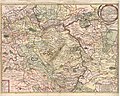
 Karte Mittelrhein.png 1,270 × 1,500; 2.95 MB
-

-
 Klimatabelle Mittelrhein.png 1,197 × 223; 18 KB
-
 LASB K Hellwig 0105.jpg 10,725 × 6,603; 12.97 MB
-
 LASB K Hellwig 0382.jpg 7,263 × 5,805; 10.35 MB
-
 LASB K Hellwig 0694.jpg 5,555 × 4,576; 5.91 MB
-
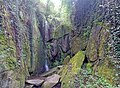 Lohbachwasserfall in St. Goar (Hauptfall).jpg 3,934 × 2,900; 3.59 MB
-
 Low water levels impacting traffic on the Rhine river.jpg 4,000 × 4,070; 6.1 MB
-
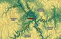
 Map Laacher See.jpg 1,270 × 903; 583 KB
-
 Massif schisteux rhenan.jpg 1,279 × 830; 699 KB
-
 Mittelrhein Hammerstein Brohl.jpg 1,280 × 960; 138 KB
-
 Mittelrhein-Burg-Stahleck-JR-E-1700-2017-05-27.jpg 4,555 × 2,997; 9.1 MB
-
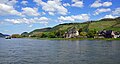 Mittelrheintal bei Andernach.jpg 5,521 × 2,965; 6.45 MB
-
 Mäuseturm im Rhein bei Bingen.jpg 3,648 × 2,736; 3.25 MB
-
 Nachtansicht von Oberwesel am Rhein.jpg 6,240 × 4,160; 5.06 MB
-
 Nähe Salzkopf – Blick über den Binger Wald in Richtung Wiebelsheim - panoramio.jpg 4,320 × 2,261; 1.48 MB
-
 Panorama Rhein Drachenfels.jpg 13,684 × 2,013; 9.17 MB
-
 Rhein by Niederkasseler - panoramio.jpg 1,024 × 683; 595 KB
-
 Rhein in Bonn bei Sonnenaufgang.jpg 3,697 × 2,079; 1.07 MB
-
 Rhein View.jpg 1,600 × 1,200; 246 KB
-
 Rhein-Freileitungskreuzung Koblenz-Niederwerth-Urbar 2010.jpg 11,170 × 2,000; 3.58 MB
-
 Rhine between Bonn and Koblenz 01.jpg 2,577 × 1,593; 2.66 MB
-
 Rhine between Bonn and Koblenz 06.jpg 3,464 × 3,000; 6.13 MB
-
 Rhine between Koblenz and Loreley 01.jpg 3,924 × 2,144; 4.8 MB
-
 Rhine MainzToKoblenz 3.jpg 4,928 × 3,264; 3.1 MB
-
 Rhine MainzToKoblenz 5.jpg 4,928 × 3,264; 3.71 MB
-
 Rhine MainzToKoblenz 6.jpg 4,928 × 3,264; 3.38 MB
-
 Rhine MainzToKoblenz 7.jpg 4,928 × 3,264; 3.62 MB
-
 Rhine MainzToKoblenz 9.jpg 4,928 × 3,264; 3.45 MB
-
 Rhine north of Koblenz, Germany. In the stream Niederwerth island. - panoramio.jpg 1,600 × 1,200; 876 KB
-
 Ruine Burg Ehrenfels Niederwald Rüdesheim Hessen.jpg 4,000 × 2,250; 4.02 MB
-
 Ruine Fürstenberg.jpg 4,282 × 3,128; 8.83 MB
-
 Schloss Drachenburg in Königswinter Aussicht zur Rheinseite.jpg 4,032 × 2,268; 3.33 MB
-
 Schönborn, Hattenheim.jpg 4,000 × 3,000; 4.45 MB
-
 St.Goarshausen Loreley Burg Katz 2016-03-27-17-13-57.jpg 4,834 × 3,121; 9.55 MB
-
 Talweitungen am Mittelrhein (Relief).png 817 × 776; 1,007 KB
-
 Train in the Middle Rhine Valley (18468072844).jpg 4,626 × 2,602; 5.65 MB
-
 Weisel und Ransel im hist. Freistaat Flaschenhals - panoramio.jpg 1,503 × 2,025; 1 MB
-
 Weyer – Nochern - Lierschied - panoramio.jpg 4,000 × 3,000; 3.45 MB
-
 Wilhelm Walther, Rhein, km44, Bingen, 2-037-038-5693.tif 6,024 × 4,022; 46.23 MB
-
 Wilhelm Walther, Rhein, km44, Bingen, 2-037-038-5694.tif 6,024 × 4,022; 46.23 MB
-
 Wilhelm Walther, Rhein, km44, Bingen, 2-037-038-5695.tif 6,024 × 4,022; 46.23 MB
-
 Winzberg ¬– Medenscheid und Lorchhausen (von vorne) - panoramio.jpg 2,726 × 1,876; 1.82 MB
-
 „Tiefflieger“ bei Oberwesel vom Günderodehaus aus gesehen - panoramio.jpg 4,000 × 3,000; 4.14 MB

.jpg)
.jpg)
.jpg)
.jpg)
.jpg)
.jpg)
.jpg)
.jpg)
.jpg)
.jpg)
.jpg)
.jpg)
.jpg)
.jpg)
.jpg)
.jpg)
.jpg)
.jpg)
.jpg)
.jpg)
.jpg)
.jpg)
.jpg)
.jpg)
.jpg)
.jpg)
.jpg)
.jpg)
.jpg)
.jpg)
.jpg)
.jpg)
.jpg)
.jpg)
.jpg)
.jpg)
.jpg)
.jpg)
.jpg)
.jpg)
.jpg)
.jpg)
.jpg)
.jpg)
.jpg)


.jpg)
_-_panoramio.jpg)


_Marienfels_und_Miehlen_(hinten_rechts)_-_panoramio.jpg)


.jpg)


.png)
.jpg)


_-_panoramio.jpg)

.jpg)