Category:Moisburger Stein
 | |||||
| Upload media | |||||
| Instance of | |||||
|---|---|---|---|---|---|
| Part of |
| ||||
| Depicts | Wolfsangel | ||||
| Made from material | |||||
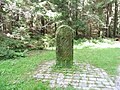
| Location | Rosengarten, Harburg, Lower Saxony, Germany | ||||
| Commissioned by | |||||
| Inception |
| ||||
| Mountain range | |||||
 | |||||
The "Moisburger Stein" (Engl.:"Moisburg Stone" or "Stone of Moisburg") was set in 1754 to mark the southern end of a forest boundary between the state forest of the then Duchy of Brunswick-Lüneburg (ruled by King George II of Great Britain in his capacity as hereditary Prince-Elector (German: Kurfürst) of Hanover), and the common forest accessible to local farmers (German: Bauernwald). It bears the monogram of George II ("GR II"), the number 65 ("No. LXV" - it was the last of 65 stones set along the eastern boundary of the state forest), the date 1750 ("ANNO MDCCL"), the year in which this boundary was originally established and the "Wolfsangel" symbol. On the reverse side is the text "Amt Moisburg". The stone can be found in the woods near Neugraben (Hamburg), Germany. This stone also marks the end of the western boundary of the state forest, which originally comprised 87 other stones, many of which are extant.
Media in category "Moisburger Stein"
The following 5 files are in this category, out of 5 total.
-
 28551 Falkenbergsweg.JPG 2,736 × 3,648; 4.02 MB
-
 Moisburger Stein Frontseite.png 2,186 × 3,040; 10.89 MB
-
 Moisburger Stein Rückseite.png 2,186 × 3,040; 12.03 MB
-
 Moisburger Stein.JPG 1,299 × 2,040; 879 KB
-
 RK 1709 1110106 Moisburger Stein.jpg 2,400 × 1,800; 1.41 MB


