Category:Mount Shasta
Zur Navigation springen
Zur Suche springen
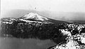
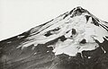
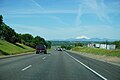
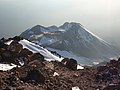
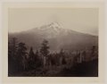
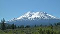
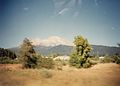
Vulkan in der Kaskadenkette, Kalifornien  The north face of Mount Shasta as seen from Siskiyou County Route A12 at sunset on January 30, 2022 | |||||
| Medium hochladen | |||||
| Ist ein(e) | |||||
|---|---|---|---|---|---|
| Benannt nach | |||||
| Liegt in Schutzgebiet | |||||
| Ort | Siskiyou County, Kalifornien, Pacific States Region | ||||
| Schutzkategorie |
| ||||
| Schlüsselereignis |
| ||||
| Gebirgszug |
| ||||
| Schartenhöhe |
| ||||
| Dominanz |
| ||||
| Höhe über dem Meeresspiegel |
| ||||
| Bezugsberg | |||||
| Verschieden von | |||||
 | |||||
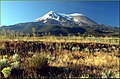
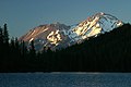
English: Media related to Mount Shasta, a stratovolcano, prominent natural and cultural landmark, and sacred mountain of Northern California, United States. The mountain is located the southern Cascade Range, the Shasta-Trinity National Forest, and Siskiyou County, California.
Unterkategorien
Es werden 18 von insgesamt 18 Unterkategorien in dieser Kategorie angezeigt:
In Klammern die Anzahl der enthaltenen Kategorien (K), Seiten (S), Dateien (D)
+
A
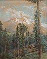
- Mount Shasta in art (24 D)
- Avalanche Gulch (2 D)
B
- Bolam Creek (3 D)
C
E
F
- Flora of Mount Shasta (8 D)
G
H
- Hiking at Mount Shasta (2 D)
M
- Mossbrae Falls (14 D)
- Mount Shasta Ski Park (4 D)
P
- Postcards of Mount Shasta (4 D)
S
- USS Shasta (AE-33) (15 D)
T
V
Medien in der Kategorie „Mount Shasta“
Folgende 160 Dateien sind in dieser Kategorie, von 160 insgesamt.
-
 -CALIFORNIA-L-0007- Mud Creek flood (50390906146).jpg 2.535 × 1.528; 2,52 MB
-

-
 2017-07-01 Mount Shasta at Sunset.jpg 4.752 × 3.168; 10,62 MB
-
 Administrative Structures - California - DPLA - e80edf93b870c749d0401bced3671668.jpg 4.918 × 3.865; 2,68 MB
-
 Ahjumawi Lava Springs SP.jpg 936 × 285; 116 KB
-
 California - Mt.Shasta - NARA - 23934599.jpg 3.544 × 2.720; 1,37 MB
-
 California - Mt.Shasta - NARA - 23934605.jpg 3.656 × 2.880; 1,11 MB
-
 Camp on Mt. Shasta (34482822553).jpg 3.072 × 2.304; 1,39 MB
-
 Casaval Ridge on Mount Shasta.jpeg 1.354 × 606; 403 KB
-
 Castle Dome and Mount Shasta.jpg 2.881 × 2.881; 2,14 MB
-
 Castle Lake and Mt. Shasta Panorama (27402546759).jpg 12.354 × 3.686; 5,51 MB
-
 Castle Lake from Heart Lake trail, Mount Shasta, California.png 3.024 × 2.268; 10,59 MB
-
 Castle Lake, Mount Shasta, California.jpg 3.024 × 2.268; 426 KB
-
 CCC enrollees carrying transplants to the fields, Shasta National Forest (3226944202).jpg 4.675 × 3.075; 7,77 MB
-
 Clear Creek side of Mount Shasta (34482559853).jpg 1.338 × 1.003; 312 KB
-
 Clibing Mt. Shasta - Flickr - Storm Rider Photography.jpg 8.192 × 5.464; 25,22 MB
-
 Climber on Mt. Shasta (34482822103).jpg 3.968 × 2.976; 1,97 MB
-
 Climbing Pilot Rock (15878847802).jpg 1.920 × 1.080; 1,3 MB
-
 CORP's Weed Hauler (Medford to Weed) near Grenada, California.jpg 1.200 × 779; 400 KB
-
 COS student lounge.jpeg 1.936 × 2.592; 2,04 MB
-
 Dawn on Mount Shasta.jpg 2.048 × 1.536; 1,72 MB
-
 Dec jan 010.JPG 4.000 × 3.000; 1,32 MB
-
 Diller Canyon.jpg 1.082 × 474; 74 KB
-
 DillerCanyonShastina.JPG 3.456 × 2.592; 3,51 MB
-
 Dusk at Helen Lake, Mount Shasta.jpg 4.000 × 2.248; 2,62 MB
-
 Fire in the Sky - Flickr - Brolafsson.jpg 3.000 × 2.000; 2,82 MB
-
 Frederick Ferdinand Schafer - Sunset on Mt. Shasta from Sissons, California.jpg 2.175 × 1.404; 255 KB
-
 Frog Fire with Mt Shasta USFS 2015 08 04.jpeg 2.560 × 1.440; 192 KB
-
-
 Grass lake (2647535529).jpg 1.024 × 768; 110 KB
-
 Greatest wonders of the world (1906) (14582911828).jpg 2.352 × 1.630; 476 KB
-
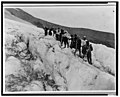 Group of men and women mountaineering on Mount Shasta, California LCCN99472528.jpg 4.096 × 3.298; 1,58 MB
-
 Group of men and women mountaineering on Mount Shasta, California LCCN99472528.tif 4.096 × 3.298; 12,88 MB
-
 Heart Lake, Mount Shasta, California.png 3.024 × 2.268; 11,23 MB
-
-
 Joe Eigo at the Mount Shasta Vortex.jpg 880 × 1.420; 730 KB
-
 Joe Eigo in an Aerial Vortex Flip.jpg 1.652 × 1.021; 509 KB
-
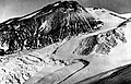
 King WhitneyGlacier.jpg 685 × 453; 23 KB
-
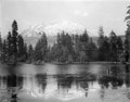 View of Mount Shasta overlooking a lake, Siskiyou County, ca.1900-1940 (CHS-5074).jpg 5.225 × 4.089; 1,36 MB
-
 Lake Shasta.jpg 2.000 × 1.163; 233 KB
-

-
 Macdoel (109819917).jpg 1.024 × 683; 176 KB
-
 Morning at macdoel california (4462332103).jpg 1.600 × 909; 461 KB
-
 Mount Shasta (15356083710).jpg 864 × 576; 327 KB
-
 Mount Shasta (3639372876).jpg 2.576 × 1.932; 428 KB
-
 Mount Shasta (8737215508).jpg 3.872 × 2.592; 2,32 MB
-
 Mount Shasta 1923.jpg 3.435 × 2.214; 605 KB
-
 Mount Shasta Dunsmuir CA - panoramio.jpg 2.822 × 1.999; 773 KB
-
 Mount Shasta from I-5 - panoramio.jpg 1.024 × 683; 126 KB
-
 Mount Shasta from I-5 descending into Cottonwood.jpg 6.000 × 4.000; 5,88 MB
-
 Mount Shasta from I-5 summer of 1967. (50933733792).jpg 1.520 × 1.500; 150 KB
-
 Mount Shasta from the PCT.jpg 2.048 × 1.536; 1.014 KB
-
 Mount Shasta majesty.jpg 3.024 × 4.032; 9,75 MB
-
 Mount Shasta North Side.jpg 2.500 × 1.653; 2,58 MB
-

-
 Mount Shasta Relief Map, SRTM-1.jpg 1.200 × 900; 779 KB
-
 Mount Shasta view westward 1994.jpeg 1.363 × 887; 520 KB
-
 Mount Shasta view westward June 1994.jpeg 1.375 × 880; 419 KB
-
 Mount Shasta viewed through trees Helen Tanner Brodt.jpg 1.133 × 1.424; 405 KB
-
 Mount Shasta, California, USA - panoramio.jpg 1.280 × 960; 591 KB
-
 Mount Shasta, California.jpg 1.100 × 732; 1,02 MB
-
-

-

-

-
-

-

-

-

-

-
 Mount Shasta, Shasta National Forest, California, USA - panoramio.jpg 5.158 × 3.416; 1,82 MB
-
 Mount Shasta, Shasta National Forest, Kalifornien, USA - panoramio.jpg 5.002 × 3.160; 1,83 MB
-
 Mount Shasta, United States (Unsplash rMWral7lvD0).jpg 5.287 × 3.526; 11,55 MB
-
 Mount Shasta, West Face ski run.JPG 4.000 × 3.000; 2,71 MB
-
 Mount Shasta.png 524 × 396; 152 KB
-
 Mountain pine tree, on Mount Shasta, Calif. LCCN95514311.jpg 7.642 × 9.591; 7,94 MB
-
 Mountain pine tree, on Mount Shasta, Calif. LCCN95514311.tif 7.642 × 9.591; 209,73 MB
-
 MountShasta2016orthophoto-LIDARslope50.tif 1.916 × 1.023; 7,48 MB
-
 Mt Shaito (i.e., Shasta(?)) LCCN98517695.jpg 9.507 × 7.532; 7,03 MB
-
 Mt Shasta (14,162 ft.) - (28681490141).jpg 5.616 × 3.744; 12,09 MB
-
 Mt Shasta from 15 750px.JPG 439 × 269; 42 KB
-
 Mt Shasta from Ahjumawi Lava Springs SP 1.jpg 1.024 × 768; 171 KB
-
 Mt Shasta from CA89.jpg 400 × 284; 118 KB
-
 Mt Shasta from Mt Shasta CA.jpg 750 × 477; 62 KB
-
 Mt Shasta Sunrise, CA 8-28-13 (10070793423).jpg 1.950 × 1.192; 273 KB
-
 Mt Shasta Sunset, CA 8-27-13 (10070739706).jpg 1.850 × 1.302; 289 KB
-
 Mt. Shasta (16376620901).jpg 5.184 × 3.456; 1,32 MB
-
 Mt. Shasta (34482821103).jpg 3.968 × 2.976; 2,41 MB
-
 Mt. Shasta (35570917312).jpg 800 × 533; 212 KB
-
 Mt. Shasta - Flickr - GregTheBusker.jpg 5.184 × 3.456; 1,44 MB
-
 Mt. Shasta - Mt. Shastina, CA 8-28-13 (10070696955).jpg 1.950 × 1.276; 853 KB
-
 Mt. Shasta - Mt. Shastina, CA 8-28-13a (10070662374).jpg 1.450 × 1.233; 515 KB
-
 Mt. Shasta - Mt. Shastina, CA 8-28-13b (10070693065).jpg 1.414 × 908; 871 KB
-
 Mt. Shasta - Mt. Shastina, CA 9-13 (22389574240).jpg 1.600 × 922; 680 KB
-
 Mt. Shasta - panoramio (2).jpg 3.865 × 1.826; 4,76 MB
-
 Mt. Shasta - panoramio.jpg 3.072 × 2.304; 1,39 MB
-
 Mt. Shasta above Castle Lake (California) (332262008).jpg 3.072 × 2.048; 4,49 MB
-
 Mt. Shasta Clean-up After (33354917053).jpg 800 × 443; 250 KB
-
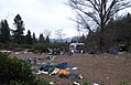 Mt. Shasta Clean-up Before (33354916623).jpg 800 × 516; 272 KB
-
 Mt. Shasta LCCN98517693.jpg 9.591 × 7.566; 6,95 MB
-
 Mt. Shasta LCCN98517693.tif 9.591 × 7.566; 207,64 MB
-
 Mt. Shasta November 2017 (38143092614).jpg 1.280 × 960; 519 KB
-
 Mt. Shasta Shadow (34482820083).jpg 3.968 × 2.976; 2,45 MB
-
 Mt. Shasta visible from the Mount Shasta city I-5 onramp.jpg 4.032 × 2.268; 4,01 MB
-
 Mt. Shasta, CA, North Face 8-28-13 (10070691925).jpg 1.550 × 1.507; 484 KB
-
 Mt. Shasta, Ca. 4a32247u.tif 346 × 420; 427 KB
-
 Mt. Shasta, CA.jpeg 490 × 365; 56 KB
-
 Mt. Shasta, Cal. 4a32217u.tif 522 × 420; 643 KB
-
 Mt. Shasta, Calif. LCCN2002718957.jpg 9.481 × 7.550; 6,32 MB
-
 Mt. Shasta, Calif. LCCN2002718957.tif 9.481 × 7.550; 204,83 MB
-
 Mt. Shasta, Calif. LCCN2005684475.jpg 7.625 × 9.650; 7,53 MB
-
 Mt. Shasta, Calif. LCCN2005684475.tif 7.625 × 9.650; 210,55 MB
-
 Mt. Shasta, California (3654960273).jpg 2.370 × 1.518; 278 KB
-
 Mt. Shasta, California (3655758270).jpg 2.443 × 1.962; 436 KB
-
 Mt. Shasta, California (3655759764).jpg 2.321 × 1.745; 297 KB
-
 Mt. Shasta, South Face 2000 (10070655564).jpg 1.750 × 1.133; 424 KB
-
 Mt. Shastina, CA, North Face 8-28-13 (10070690295).jpg 1.279 × 1.450; 432 KB
-
 MtShasta SnowCapped.jpg 2.184 × 1.387; 1,93 MB
-
 My Public Lands Roadtrip- Cascade-Siskiyou National Monument in oregon (18475751843).jpg 2.000 × 1.040; 365 KB
-
 My Public Lands Roadtrip- Cascade-Siskiyou National Monument in oregon (18908719600).jpg 2.000 × 1.333; 1.012 KB
-
 My Public Lands Roadtrip- Cascade-Siskiyou National Monument in oregon (19096442665).jpg 1.333 × 2.000; 934 KB
-
 Near Montague, CA Mount Shasta from I-5, 2006 - panoramio.jpg 1.600 × 1.200; 609 KB
-
 Night at Shasta (28237106858).jpg 2.048 × 3.072; 10,22 MB
-
 Mt. Shasta, Mt. Shasta, Calif (NYPL b12647398-62028).tiff 2.500 × 1.590; 11,38 MB
-
 Mt. Shasta, Mt. Shasta, Calif (NYPL b12647398-62031).tiff 2.432 × 1.505; 10,48 MB
-
 Pilot Rock Summit.JPG 4.320 × 3.240; 4,75 MB
-
 Pithya cupressina (Batsch) Fuckel 324104 crop.jpg 3.459 × 2.105; 1,76 MB
-
 Rogue Valley Inversion 2.jpg 14.143 × 2.501; 11,97 MB
-
 Sagebrush and Mt. Shasta (5657782867).jpg 2.896 × 1.666; 1,57 MB
-
 Shasta and Shastina June 2012 - panoramio.jpg 4.320 × 2.432; 4,52 MB
-
 Shasta At Night (258050167).jpeg 1.365 × 2.048; 2,01 MB
-
 Shasta corral - Flickr - lorenkerns.jpg 3.664 × 2.061; 3,5 MB
-
 Shasta land Slopes LCCN98517684.jpg 7.650 × 9.591; 8,5 MB
-
 Shasta Mountain.jpg 3.687 × 2.046; 1,25 MB
-
 ShastaNW.jpg 1.280 × 878; 414 KB
-
 Shastina from Misery Hill.jpeg 1.349 × 886; 862 KB
-
 Sisson Hatchery, Sisson, California.jpg 1.213 × 927; 302 KB
-
 Southern Pacific Shasta Daylight Mount Shasta.JPG 1.309 × 821; 444 KB
-
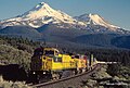
 SP 8327 at Black Butte, CA in August 1982 (33223631001).jpg 1.960 × 1.041; 2,1 MB
-
 SP 8380 at Black Butte, CA in August 1982 (32508307864).jpg 2.000 × 1.185; 1,77 MB
-
 SP 8871 and 8509 at Black Butte, CA in July 1982 (33101799312).jpg 2.000 × 1.355; 2,89 MB
-
 SP 8871 and 8509 at Black Butte, CA in July 1982 (33257575105).jpg 2.000 × 1.327; 2,42 MB
-
 Sunrise on Mount Shasta.jpg 1.000 × 672; 55 KB
-
 The American Museum of Natural History (1891) (17922472438).jpg 1.946 × 2.022; 1,38 MB
-
-
 Tule Lake field work scn 0016 (15845239502).jpg 1.930 × 1.376; 1,06 MB
-
 Tundra Swans and Mt. Shasta (5658366212).jpg 2.896 × 1.944; 2,54 MB
-
 View from Bunny Flat Trailhead, Mount Shasta, California.png 3.024 × 2.268; 8,85 MB
-
 View of Mount Shasta, Calif. 1a34237v.jpg 1.024 × 793; 217 KB
-
 Views from Cascade-Siskiyou National Monument -- Mount Shasta (17241553520).jpg 2.000 × 1.334; 2,47 MB
-
 Volcanic Legacy Scenic Byway - Mount Shasta from the Byway - NARA - 7722705.jpg 3.640 × 2.371; 7,71 MB
-
 Volcanic Legacy Scenic Byway - Mount Shasta Sunset - NARA - 7722708.jpg 3.592 × 2.443; 8,07 MB
-
 Volcanic Legacy Scenic Byway - Snow-Capped Mount Shasta - NARA - 7722709.jpg 3.640 × 2.311; 6,65 MB
-
 Volcanoes - General - All States - DPLA - c6d5ff2d81645fe5f0ec295e00c72f41.jpg 4.908 × 4.053; 2,2 MB
-
 White Lake and Mount Shasta (5658356450).jpg 2.896 × 1.944; 2,81 MB
-
 Whitney Glacier.jpeg 6.091 × 3.927; 5,92 MB
-
 Yak's koffee shop and cafe, just south of mount shasta (15025794485).jpg 2.458 × 3.212; 2,87 MB
-
 Ztrain at mt shasta (3875678050).jpg 1.200 × 811; 679 KB
-
 Шаста над городом - panoramio.jpg 3.504 × 2.336; 3,12 MB
.jpg)
%27_(11287845205).jpg)


.jpg)


.jpg)
.jpg)
_near_Grenada,_California.jpg)


,_RP-F-2012-96-224.jpg)
.jpg)
_(14582911828).jpg)


.jpg)


.jpg)

.jpg)
.jpg)
.jpg)
.jpg)
.jpg)
.jpg)


.jpg)


.jpg)


)_LCCN98517695.jpg)
_-_(28681490141).jpg)


.jpg)
.jpg)
.jpg)
.jpg)
.jpg)

.jpg)
.jpg)
.jpg)
.jpg)
.jpg)

_(332262008).jpg)
.jpg)
.jpg)

.jpg)
.jpg)

.jpg)


.jpg)
.jpg)
.jpg)
.jpg)
.jpg)

.jpg)
.jpg)
.jpg)

.jpg)

_Fuckel_324104_crop.jpg)
.jpg)

.jpeg)


.jpg)
.jpg)
.jpg)
.jpg)

_(17922472438).jpg)
_(14784315392).jpg)
.jpg)
.jpg)


.jpg)


.jpg)

.jpg)
.jpg)

.jpg)
.jpg)
.jpg)
Kategorien:
- Stratovolcanoes in California
- Geology of Siskiyou County, California
- Mountains of the Cascade Range
- National Natural Landmarks of California
- Sacred mountains
- Shasta-Trinity National Forest
- Subduction volcanoes in California
- 4320s mountains of the United States
- Subglacial volcanoes in the United States
- Glaciers of California
- Holocene volcanism of California
- Quaternary volcanism of California