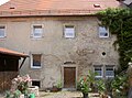
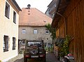
Category:Mühle Stadtmühlweg 11 (Neustadt an der Waldnaab)
Jump to navigation
Jump to search
| Object location | | View all coordinates using: OpenStreetMap |
|---|
This is the category of the Bavarian Baudenkmal (cultural heritage monument) with the ID D-3-74-139-20 (Wikidata)
|
| Upload media | |||||
| Instance of | |||||
|---|---|---|---|---|---|
| Location | Neustadt an der Waldnaab, Upper Palatinate, Bavaria, Germany | ||||
| Street address |
| ||||
| Heritage designation | |||||
 | |||||
Media in category "Mühle Stadtmühlweg 11 (Neustadt an der Waldnaab)"
The following 8 files are in this category, out of 8 total.
-
 NeustadtMühleStadtmühlweg11 01.jpg 2,304 × 1,704; 943 KB
-
 NeustadtMühleStadtmühlweg11 02.jpg 2,304 × 1,704; 902 KB
-
 NeustadtMühleStadtmühlweg11 03.jpg 2,304 × 1,704; 881 KB
-
 NeustadtMühleStadtmühlweg11 04.jpg 2,304 × 1,704; 903 KB
-
 NeustadtMühleStadtmühlweg11 05.jpg 2,304 × 1,704; 927 KB
-
 NeustadtMühleStadtmühlweg11 06.jpg 2,304 × 1,704; 926 KB
-
 NeustadtMühleStadtmühlweg11 07.jpg 2,304 × 1,704; 864 KB
-
 NeustadtMühleStadtmühlweg11 08.jpg 2,304 × 1,704; 921 KB


