Category:Nederlands Hervormde Kerk (Avenhorn)
Jump to navigation
Jump to search
| Object location | | View all coordinates using: OpenStreetMap |
|---|
 | |||||
| Upload media | |||||
| Instance of |
| ||||
|---|---|---|---|---|---|
| Location | Avenhorn, North Holland, Netherlands | ||||
| Street address |
| ||||
| Heritage designation |
| ||||
 | |||||
Kerk:
|
This is a category about rijksmonument number 38767
|
Toren:
|
This is a category about rijksmonument number 38768
|
| Address |
|
Media in category "Nederlands Hervormde Kerk (Avenhorn)"
The following 33 files are in this category, out of 33 total.
-
 Aanzicht - Avenhorn - 20026479 - RCE.jpg 1,200 × 886; 210 KB
-
 Aanzicht - Avenhorn - 20026480 - RCE.jpg 1,200 × 893; 180 KB
-
 Avenhorn, kerk foto10 2011-04-17 11.53.JPG 4,416 × 3,312; 15.09 MB
-
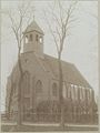
 Avenhorn.jpg 500 × 281; 127 KB
-
 Detail oostgevel - Avenhorn - 20026488 - RCE.jpg 1,200 × 1,195; 456 KB
-
 Gedeelte oostgevel - Avenhorn - 20026487 - RCE.jpg 1,185 × 1,200; 376 KB
-
 Gedeelte zuidgevel - Avenhorn - 20026491 - RCE.jpg 1,200 × 1,200; 374 KB
-
 Ingang-kerk-Avenhorn.jpg 2,816 × 4,192; 6.13 MB
-
 Interieur - Avenhorn - 20026481 - RCE.jpg 1,200 × 895; 165 KB
-
 Interieur naar het oosten - Avenhorn - 20026495 - RCE.jpg 1,200 × 960; 225 KB
-
 Interieur naar het oosten - Avenhorn - 20026496 - RCE.jpg 1,200 × 948; 246 KB
-
 Interieur naar het westen - Avenhorn - 20026494 - RCE.jpg 1,200 × 951; 204 KB
-
 Kapconstructie koor - Avenhorn - 20026497 - RCE.jpg 1,200 × 953; 229 KB
-
 Kerk-Avenhorn-1.jpg 4,279 × 2,849; 5.47 MB
-
 Kerk-Avenhorn-2.jpg 3,982 × 2,650; 5.11 MB
-
 Kerk-Avenhorn-3.jpg 2,808 × 4,168; 5.35 MB
-
 Na de restauratie - Avenhorn - 20026477 - RCE.jpg 863 × 1,200; 277 KB
-
 Na de restauratie - Avenhorn - 20026478 - RCE.jpg 886 × 1,200; 279 KB
-
 Noordgevel - Avenhorn - 20026484 - RCE.jpg 1,200 × 951; 327 KB
-
 Oostgevel - Avenhorn - 20026485 - RCE.jpg 949 × 1,200; 283 KB
-
 Oostzijde - Avenhorn - 20026486 - RCE.jpg 1,200 × 1,200; 378 KB
-
 Overzicht vanuit het zuidwesten - Avenhorn - 20322164 - RCE.jpg 897 × 1,200; 174 KB
-
 Overzicht zuid-west zijde - Avenhorn - 20026482 - RCE.jpg 954 × 1,200; 269 KB
-
 Stoep westgevel - Avenhorn - 20026493 - RCE.jpg 1,198 × 1,200; 344 KB
-
 Tekst-bouw-toren.jpg 4,119 × 2,635; 5.79 MB
-
 Tekst-herbouw-toren.jpg 3,080 × 2,090; 4.84 MB
-
 Toren-kerk-avenhorn-1.jpg 2,832 × 4,208; 3.48 MB
-
 Toren-kerk-avenhorn-2.jpg 2,344 × 3,496; 3.59 MB
-
 Toren-kerk-avenhorn-3.jpg 2,136 × 3,208; 1.37 MB
-
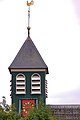
 Torentje - Avenhorn - 20026492 - RCE.jpg 1,197 × 1,200; 203 KB
-
 Westgevel - Avenhorn - 20026483 - RCE.jpg 945 × 1,200; 277 KB
-
 Zuidgevel - Avenhorn - 20026489 - RCE.jpg 1,200 × 960; 287 KB
-
 Zuidgevel - Avenhorn - 20026490 - RCE.jpg 937 × 1,200; 261 KB


