Category:Nederlands Hervormde Kerk (Odijk)
Jump to navigation
Jump to search
| Object location | | View all coordinates using: OpenStreetMap |
|---|
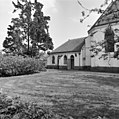
church in Odijk, Netherlands  | |||||
| Upload media | |||||
| Instance of | |||||
|---|---|---|---|---|---|
| Location | Odijk, Utrecht, Netherlands | ||||
| Street address |
| ||||
| Located on street |
| ||||
| Heritage designation |
| ||||
| Inception |
| ||||
 | |||||
|
This is a category about rijksmonument number 11290
|
| Address |
|
Media in category "Nederlands Hervormde Kerk (Odijk)"
The following 14 files are in this category, out of 14 total.
-
 Consistorie kerk - Odijk - 20170678 - RCE.jpg 1,197 × 1,200; 438 KB
-
 Doopvont - Odijk - 20170682 - RCE.jpg 1,197 × 1,200; 244 KB
-
 Exterieur noord-west gevel - Odijk - 20170675 - RCE.jpg 1,200 × 1,192; 349 KB
-
 Exterieur noordgevel - Odijk - 20170674 - RCE.jpg 1,195 × 1,200; 410 KB
-
 Exterieur zuidgevel - Odijk - 20170676 - RCE.jpg 1,200 × 1,195; 331 KB
-
 Exterieur zuidgevel koor - Odijk - 20170677 - RCE.jpg 1,186 × 1,200; 266 KB
-
 Het Witte Kerkje te Odijk.jpg 5,223 × 7,002; 24.73 MB
-
 Interieur naar het oosten - Odijk - 20170679 - RCE.jpg 1,192 × 1,200; 240 KB
-
 Interieur naar het westen - Odijk - 20170680 - RCE.jpg 1,200 × 1,200; 251 KB
-
 ODIJK ST.jpg 2,592 × 4,608; 1.38 MB
-
 OdijkKerk.jpg 2,048 × 1,536; 439 KB
-
 Preekstoel - Odijk - 20170681 - RCE.jpg 1,195 × 1,200; 201 KB
-
 Witte kerkje in Odijk bij zonsondergang.JPG 2,600 × 1,950; 1.93 MB
-
 Witte kerkje Odijk.JPG 4,000 × 3,000; 3.48 MB


