Category:Nederlands Hervormde Kerk, Schijndel
Jump to navigation
Jump to search
| Object location | | View all coordinates using: OpenStreetMap |
|---|
church building in Meierijstad, Netherlands .JPG) | |||||
| Upload media | |||||
| Instance of | |||||
|---|---|---|---|---|---|
| Location | Schijndel, North Brabant, Netherlands | ||||
| Street address |
| ||||
| Located on street |
| ||||
| Heritage designation |
| ||||
| Inception |
| ||||
| Religion or worldview | |||||
 | |||||
Nederlands: Ned. Hervormde Kerk Schijndel - anno 1808 - buiten gebruik als kerk sinds 1979 - sindsdien in gebruik als bloemenwinkel
|
This is a category about rijksmonument number 33567
|
| Address |
|
Media in category "Nederlands Hervormde Kerk, Schijndel"
The following 14 files are in this category, out of 14 total.
-
 Exterieur - Schijndel - 20197384 - RCE.jpg 788 × 1,200; 203 KB
-
 Exterieur, hoofdstraat 150 - Schijndel - 20197383 - RCE.jpg 814 × 1,200; 276 KB
-
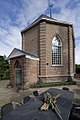 Foto kerk 11.jpg 709 × 1,063; 335 KB
-
 Foto kerk 18.jpg 1,063 × 709; 256 KB
-
 Int, overzicht preekstoel - Schijndel - 20001771 - RCE.jpg 1,200 × 970; 158 KB
-

-
 Interieur, vloer (open gebroken) - Schijndel - 20001772 - RCE.jpg 1,200 × 988; 226 KB
-
 Interieur, vloer (open gebroken) - Schijndel - 20001773 - RCE.jpg 1,200 × 970; 263 KB
-
 Interieur, vloer (open gebroken) - Schijndel - 20001775 - RCE.jpg 1,200 × 970; 187 KB
-
 Keramiektegels van de verwijderde vloer - Schijndel - 20001776 - RCE.jpg 1,190 × 1,200; 401 KB
-
 Overzicht westgevel - Schijndel - 20001770 - RCE.jpg 963 × 1,200; 287 KB
-
 Overzicht westgevel - Schijndel - 20347697 - RCE.jpg 1,191 × 1,200; 413 KB
-
 T.T vm Hervormde Kerk Schijndel (1).JPG 3,072 × 4,608; 3.31 MB
-
 T.T vm Hervormde Kerk Schijndel (2).JPG 3,072 × 4,608; 3.33 MB


_-_Schijndel_-_20001772_-_RCE.jpg)
_-_Schijndel_-_20001773_-_RCE.jpg)
_-_Schijndel_-_20001775_-_RCE.jpg)


.JPG)