Category:Nederlands Hervormde kerk Neerbosch
Jump to navigation
Jump to search
| Object location | | View all coordinates using: OpenStreetMap |
|---|
church building in Neerbosch, Netherlands  | |||||
| Upload media | |||||
| Instance of |
| ||||
|---|---|---|---|---|---|
| Location | Nijmegen, Gelderland, Netherlands | ||||
| Street address |
| ||||
| Heritage designation |
| ||||
 | |||||
Nederlands: Antonius Abtkerk - anno 15e eeuw - Als kerk buiten gebruik
Kerk:
|
This is a category about rijksmonument number 31205
|
Toren:
|
This is a category about rijksmonument number 31206
|
| Address |
|
Media in category "Nederlands Hervormde kerk Neerbosch"
The following 14 files are in this category, out of 14 total.
-
 Anonieme tekening N.M.Comm. 351 - Neerbosch - 20163265 - RCE.jpg 1,200 × 953; 230 KB
-
 Exterieur NOORDGEVEL - Hees - 20295642 - RCE.jpg 1,200 × 960; 332 KB
-
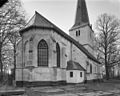 Exterieur NOORDOOST GEVEL - Hees - 20295274 - RCE.jpg 1,200 × 958; 329 KB
-
 Exterieur OVERZICHT NAAR HET NOORDWESTEN - Hees - 20295641 - RCE.jpg 951 × 1,200; 359 KB
-
 Exterieur ZUIDGEVEL - Hees - 20295276 - RCE.jpg 957 × 1,200; 430 KB
-
 Exterieur ZUIDOOST GEVEL - Hees - 20295275 - RCE.jpg 953 × 1,200; 394 KB
-
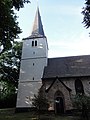
 Kerk vanuit het oosten - Neerbosch - 20163261 - RCE.jpg 873 × 1,200; 300 KB
-
 Kerk vanuit het zuid-oosten - Neerbosch - 20163260 - RCE.jpg 875 × 1,200; 310 KB
-
 Nederlands Hervormde kerk Neerbosch Nijmegen Witte kerkje van Neerbosch gezien vanaf A73.jpg 5,819 × 3,746; 11.14 MB
-
 Nederlands Hervormde kerk van Neerbosch Witte kerkje van Neerbosch Nijmegen II.jpg 5,982 × 3,905; 12.4 MB
-
 Nederlands Hervormde kerk van Neerbosch Witte kerkje van Neerbosch Nijmegen.jpg 6,008 × 3,892; 3.6 MB
-
 Nijmegen Rijksmonument 31205 Kerk Dorpsstraat 112 Neerbosch.JPG 3,648 × 2,736; 3.89 MB
-
 Nijmegen Rijksmonument 31206 Kerktoren Dorpsstraat 112 Neerbosch.JPG 2,736 × 3,648; 3.19 MB
-
 Witte kerkje Neerbosch.jpg 2,048 × 1,536; 2.05 MB


