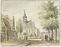
Category:Nederlands hervormde kerk, Heemstede
Jump to navigation
Jump to search
| Object location | | View all coordinates using: OpenStreetMap |
|---|
church building in Heemstede, Netherlands  | |||||
| Upload media | |||||
| Instance of | |||||
|---|---|---|---|---|---|
| Location | Heemstede, North Holland, Netherlands | ||||
| Street address |
| ||||
| Located on street |
| ||||
| Heritage designation |
| ||||
| Inception |
| ||||
| Religion or worldview | |||||
 | |||||
|
This is a category about rijksmonument number 21125
|
| Address |
|
Subcategories
This category has only the following subcategory.
G
- Grave monument Adriaen Pauw (2 F)
Media in category "Nederlands hervormde kerk, Heemstede"
The following 51 files are in this category, out of 51 total.
-
 ' t Dorp Heemstede bij Haarlem, Inventarisnummer NL-HlmNHA 1100 KNA006003154.JPG 3,096 × 2,298; 1.93 MB
-
 , Inventarisnummer NL-HlmNHA 1100 KNA006003146.JPG 2,864 × 2,176; 1.63 MB
-
 , Inventarisnummer NL-HlmNHA 1100 KNA006003147.JPG 2,473 × 1,926; 1.28 MB
-
 , Inventarisnummer NL-HlmNHA 1100 KNA006003144.JPG 3,500 × 2,303; 2.06 MB
-
 Exterieur - Heemstede - 20104592 - RCE.jpg 1,200 × 953; 396 KB
-
 Exterieur NOORDWESTGEVEL - Heemstede - 20282946 - RCE.jpg 1,200 × 953; 385 KB
-
 Exterieur OOSTGEVEL - Heemstede - 20282948 - RCE.jpg 1,200 × 953; 384 KB
-
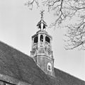 Exterieur VIERING TOREN - Heemstede - 20282950 - RCE.jpg 1,200 × 1,199; 320 KB
-
 Exterieur VIERING TOREN - Heemstede - 20282951 - RCE.jpg 1,197 × 1,200; 294 KB
-
 Exterieur ZUIDGEVEL - Heemstede - 20282949 - RCE.jpg 1,200 × 953; 345 KB
-
 Exterieur ZUIDOOSTGEVEL - Heemstede - 20282947 - RCE.jpg 953 × 1,200; 392 KB
-
 Heemstede, kerk3 foto4 2011-06-12 10.53.JPG 4,416 × 3,312; 7.03 MB
-
 Heemstede-kerk.jpg 1,944 × 2,296; 414 KB
-
 Interieur detail glas in loodraam tijdens restauratie - Heemstede - 20104594 - RCE.jpg 1,200 × 1,200; 254 KB
-
 Interieur detail glas in loodraam tijdens restauratie - Heemstede - 20104596 - RCE.jpg 1,195 × 1,200; 244 KB
-
-
 Interieur detail glas in loodraam tijdens restauratie. - Heemstede - 20104595 - RCE.jpg 1,200 × 1,200; 300 KB
-
 Interieur detail glas in loodraam tijdens restauratie. - Heemstede - 20104597 - RCE.jpg 1,200 × 1,179; 229 KB
-
 Interieur detail glas in loodraam tijdens restauratie. - Heemstede - 20104598 - RCE.jpg 1,200 × 1,159; 239 KB
-
 Interieur detail glas in loodraam tijdens restauratie. - Heemstede - 20104599 - RCE.jpg 1,200 × 1,188; 291 KB
-
 Interieur detail glas in loodraam tijdens restauratie. - Heemstede - 20104600 - RCE.jpg 1,200 × 1,200; 216 KB
-
 Interieur detail glas in loodraam tijdens restauratie. - Heemstede - 20104601 - RCE.jpg 1,200 × 1,186; 214 KB
-
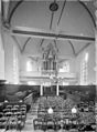 Interieur naar het noorden - Heemstede - 20104589 - RCE.jpg 885 × 1,200; 173 KB
-
 Interieur naar het zuiden - Heemstede - 20104590 - RCE.jpg 885 × 1,200; 184 KB
-
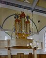 Interieur, aanzicht orgel, orgelnummer 627 - Heemstede - 20359350 - RCE.jpg 956 × 1,200; 165 KB
-

-
 INTERIEUR, GLAS IN LOODRAAM - Heemstede - 20262538 - RCE.jpg 775 × 1,200; 122 KB
-
 INTERIEUR, GLAS IN LOODRAAM - Heemstede - 20262539 - RCE.jpg 775 × 1,200; 118 KB
-
 INTERIEUR, GLAS IN LOODRAAM - Heemstede - 20262540 - RCE.jpg 775 × 1,200; 128 KB
-
 INTERIEUR, GLAS IN LOODRAAM - Heemstede - 20262541 - RCE.jpg 787 × 1,200; 169 KB
-
 INTERIEUR, GLAS IN LOODRAAM - Heemstede - 20262542 - RCE.jpg 775 × 1,200; 132 KB
-
 INTERIEUR, GLAS IN LOODRAAM - Heemstede - 20262543 - RCE.jpg 775 × 1,200; 163 KB
-

-
 INTERIEUR, GLAS IN LOODRAAM, DETAIL - Heemstede - 20262544 - RCE.jpg 795 × 1,200; 130 KB
-
 INTERIEUR, GLAS IN LOODRAAM, DETAIL - Heemstede - 20262545 - RCE.jpg 793 × 1,200; 133 KB
-
 INTERIEUR, GLAS IN LOODRAAM, DETAIL - Heemstede - 20262546 - RCE.jpg 806 × 1,200; 142 KB
-
 INTERIEUR, HERENBANK - Heemstede - 20282956 - RCE.jpg 1,200 × 958; 235 KB
-
 INTERIEUR, KOOR, GEWELFSCHILDERING - Heemstede - 20282960 - RCE.jpg 1,191 × 1,200; 276 KB
-
 INTERIEUR, KOOR, GRAFMONUMENT (A. PAUW) - Heemstede - 20282958 - RCE.jpg 961 × 1,200; 195 KB
-
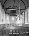
 INTERIEUR, NAAR HET OOSTEN - Heemstede - 20282953 - RCE.jpg 1,200 × 955; 207 KB
-
 INTERIEUR, NAAR HET WESTEN - Heemstede - 20282952 - RCE.jpg 955 × 1,200; 189 KB
-
 INTERIEUR, ORGEL - Heemstede - 20282954 - RCE.jpg 955 × 1,200; 215 KB
-
 INTERIEUR, ORGEL, KLAVIATUUR - Heemstede - 20282955 - RCE.jpg 1,200 × 1,197; 238 KB
-
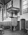 INTERIEUR, PREEKSTOEL - Heemstede - 20282957 - RCE.jpg 946 × 1,200; 215 KB
-
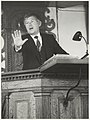 Lezing in de Oude Kerk door S. Groenveld i.v.m. herdenking A. Pauw. NL-HlmNHA 54015812.JPG 2,166 × 2,885; 1.31 MB
-
 Lezing in de Oude Kerk door S. Groenveld i.v.m. herdenking A. Pauw. NL-HlmNHA 54015813.JPG 2,893 × 2,155; 1.24 MB
-

-
 Nederlands Hervormde Kerk, gebouwd in 1625. NL-HlmNHA 54011230.JPG 2,714 × 2,164; 1.02 MB
-

-

-


_-_Heemstede_-_20262548_-_RCE.jpg)


_-_Heemstede_-_20262547_-_RCE.jpg)


_-_Heemstede_-_20282958_-_RCE.jpg)


