Category:Newchurch, Kent
Jump to navigation
Jump to search
village and civil parish in Kent  | |||||
| Upload media | |||||
| Instance of | |||||
|---|---|---|---|---|---|
| Location | Folkestone and Hythe, Kent, South East England, England | ||||
 | |||||
Subcategories
This category has the following 2 subcategories, out of 2 total.
N
R
- RAF Newchurch (5 F)
Media in category "Newchurch, Kent"
The following 200 files are in this category, out of 277 total.
(previous page) (next page)-
 A Battle of Britain pilot remembered - geograph.org.uk - 5118841.jpg 4,608 × 3,456; 3.44 MB
-
 A ewe and two lambs - geograph.org.uk - 5315384.jpg 640 × 480; 106 KB
-
 Annexe under construction - geograph.org.uk - 3516252.jpg 913 × 684; 199 KB
-
 Arable land by St Mary's Rd - geograph.org.uk - 4798952.jpg 640 × 383; 40 KB
-
 Barn in Millbank Farm - geograph.org.uk - 2151825.jpg 3,072 × 2,304; 2.04 MB
-
 Bilisington Sewer - looking southwards. - geograph.org.uk - 2088413.jpg 3,072 × 2,304; 2.33 MB
-
 Bilsington Sewer - geograph.org.uk - 2088082.jpg 3,072 × 2,304; 2.22 MB
-
 Bilsington Sewer - geograph.org.uk - 2174179.jpg 3,072 × 2,304; 1.85 MB
-
 Bilsington Sewer - looking towards Newchurch - geograph.org.uk - 2088410.jpg 3,072 × 2,304; 1.86 MB
-
 Bilsington Sewer and Newchurch - geograph.org.uk - 2088090.jpg 3,072 × 2,304; 2.06 MB
-
 Bilsington Sewer leading to Newchurch - geograph.org.uk - 2088053.jpg 3,072 × 2,304; 2.33 MB
-
 Bilsington Sewer to Newchurch Tower Mill - geograph.org.uk - 2088389.jpg 3,072 × 2,304; 1.99 MB
-
 Black Bull House, Newchurch - geograph.org.uk - 2088110.jpg 3,072 × 2,304; 1.6 MB
-
 Blackmanstone Bridge - geograph.org.uk - 2574660.jpg 2,256 × 1,496; 923 KB
-
 Brenzett Sewer (2) - geograph.org.uk - 3196896.jpg 2,256 × 1,496; 710 KB
-
 Brenzett Sewer - geograph.org.uk - 3196891.jpg 2,256 × 1,496; 937 KB
-
 Brenzett Sewer - looking towards Ivychurch - geograph.org.uk - 2151929.jpg 3,072 × 2,304; 2.37 MB
-
 Brenzett Sewer - looking towards Melon Lane - geograph.org.uk - 2151925.jpg 3,072 × 2,304; 2.59 MB
-
 Brenzett Sewer near Melon Farm - geograph.org.uk - 2151916.jpg 3,072 × 2,304; 1.77 MB
-
 Bridge on Honeywood Lane - geograph.org.uk - 2088049.jpg 3,072 × 2,304; 1.58 MB
-
 Bridge on the Sheaty Sewer - geograph.org.uk - 2153629.jpg 3,072 × 2,304; 1.65 MB
-
 Bridge over drainage channel in Romney Marshes - geograph.org.uk - 2153502.jpg 3,072 × 2,304; 2.08 MB
-
 Building construction, Will’s Farm, Wills Lane - geograph.org.uk - 4749786.jpg 3,264 × 2,448; 2.01 MB
-
 Building construction, Will’s Farm, Wills Lane - geograph.org.uk - 4749794.jpg 3,151 × 2,448; 2.39 MB
-
 Carter Bungalow - geograph.org.uk - 2174162.jpg 3,072 × 2,304; 1.69 MB
-
 Close up of Newchurch village sign - geograph.org.uk - 3397122.jpg 3,000 × 4,000; 3.43 MB
-
 Coach House and Manor House - geograph.org.uk - 2153701.jpg 3,072 × 2,304; 1.58 MB
-
 Communal Garden near Newchurch - geograph.org.uk - 2150759.jpg 3,072 × 2,304; 1.57 MB
-
 Cottage at Newchurch - geograph.org.uk - 2210827.jpg 1,117 × 756; 645 KB
-
 Cottage in Newchurch - geograph.org.uk - 4993504.jpg 4,608 × 3,456; 3.59 MB
-
 Crook Manor - geograph.org.uk - 2088458.jpg 3,072 × 2,304; 2.06 MB
-
 Crop Field near Hill's Farm - geograph.org.uk - 3209077.jpg 2,256 × 1,496; 902 KB
-
 Crop Field near Oldhouse Bridge - geograph.org.uk - 1944405.jpg 1,024 × 768; 322 KB
-
 Crop Field off Chittenden's Lane - geograph.org.uk - 3209259.jpg 2,256 × 1,496; 916 KB
-
 Crop Field on Romney Marsh - geograph.org.uk - 3209072.jpg 2,256 × 1,496; 912 KB
-
 Dark soils - geograph.org.uk - 4792440.jpg 640 × 396; 60 KB
-
 Delightful cottage in Newchurch - geograph.org.uk - 3931815.jpg 640 × 461; 78 KB
-
 Derelict Shed near Honeywood Farm - geograph.org.uk - 1944531.jpg 1,024 × 768; 276 KB
-
 Distant sheep on Romney Marsh - geograph.org.uk - 3554510.jpg 640 × 480; 102 KB
-
 Drain and clouds in the Romney Marshes - geograph.org.uk - 2171762.jpg 3,072 × 2,304; 1.22 MB
-
 Drain in the Romney Marshes - geograph.org.uk - 2171758.jpg 3,072 × 2,304; 1.55 MB
-
 Drainage Channel - looking northwards - geograph.org.uk - 2153523.jpg 3,072 × 2,231; 1.71 MB
-
 Drainage channel and North Fording Farm - geograph.org.uk - 2152089.jpg 3,072 × 2,304; 2.3 MB
-
 Drainage channel beside a lane in the Romney Marshes - geograph.org.uk - 2174173.jpg 3,072 × 2,304; 2.04 MB
-
 Drainage Channel near Bellfield Farm - geograph.org.uk - 2088554.jpg 3,072 × 2,304; 2.32 MB
-
 Drainage channel near North Fording Farm - geograph.org.uk - 2152072.jpg 3,072 × 2,304; 1.83 MB
-
 Drainage channel near Norwood Farm - geograph.org.uk - 2153613.jpg 3,072 × 2,304; 1.79 MB
-
 Drainage channel near Tatnam Bridge - geograph.org.uk - 2049130.jpg 960 × 1,280; 626 KB
-
 Drainage channel near Tatnam Bridge - geograph.org.uk - 2049184.jpg 1,280 × 960; 623 KB
-
 Drainage channel towards Brookfield - geograph.org.uk - 2153510.jpg 3,072 × 2,304; 1.39 MB
-
 Drainage Channel towards Lodgeland Farm - geograph.org.uk - 2151921.jpg 3,072 × 2,304; 3.12 MB
-
 Drainage channel towards Newchurch - geograph.org.uk - 2174174.jpg 3,072 × 2,304; 1.98 MB
-
 Drainage channel towards Pickney Bush Lane - geograph.org.uk - 2153573.jpg 3,072 × 2,304; 2.22 MB
-
 Eastbridge Sewer - geograph.org.uk - 4792427.jpg 640 × 426; 80 KB
-
 Eastbridge Sewer, off Chapel Lane - geograph.org.uk - 3197252.jpg 2,256 × 1,496; 928 KB
-
 Electricity Pylons near Newchurch - geograph.org.uk - 3196914.jpg 2,256 × 1,496; 856 KB
-
 End of a ditch, in the Romney Marshes - geograph.org.uk - 2087967.jpg 3,072 × 2,304; 2.57 MB
-

-
 Farm bridge beside the Bilsington Sewer - geograph.org.uk - 2088079.jpg 3,072 × 2,304; 2.09 MB
-
 Farm bridge in Romney Marshes - geograph.org.uk - 2171753.jpg 3,072 × 2,304; 1.59 MB
-
 Farm bridge over the Wallsfoot Sewer - geograph.org.uk - 2088004.jpg 3,072 × 2,304; 1.61 MB
-
 Farm buildings near Squires Farm - geograph.org.uk - 408599.jpg 558 × 429; 39 KB
-
 Farm Bungalow, Wills Lane - geograph.org.uk - 4749773.jpg 3,264 × 2,448; 3.26 MB
-
 Farm track near Newchurch - geograph.org.uk - 2150762.jpg 3,072 × 2,304; 2.09 MB
-
 Farmland - geograph.org.uk - 4792443.jpg 640 × 426; 67 KB
-
 Field drain - geograph.org.uk - 4792446.jpg 640 × 426; 74 KB
-
 Field edge near New Barn Farm - geograph.org.uk - 4993512.jpg 4,608 × 3,456; 3.39 MB
-
 Field in Romney Marshes - geograph.org.uk - 2153488.jpg 3,072 × 2,304; 2.01 MB
-
 Field near Blackmanstone Bridge - geograph.org.uk - 1858164.jpg 1,024 × 768; 151 KB
-
 Field near Chittenden's Lane - geograph.org.uk - 2057343.jpg 1,280 × 960; 656 KB
-
 Field near Honeychild Manor - geograph.org.uk - 2152117.jpg 3,072 × 1,728; 1.35 MB
-
 Field of wheat on Romney Marsh - geograph.org.uk - 2049045.jpg 1,280 × 960; 620 KB
-
 Field of wheat, Romney Marsh - geograph.org.uk - 3554501.jpg 640 × 480; 80 KB
-
 Field west of Gammon's Farm Lane - geograph.org.uk - 5315310.jpg 640 × 480; 149 KB
-
 Fields near Gammon's Farm Lane - geograph.org.uk - 2171750.jpg 3,072 × 1,728; 1.07 MB
-
 Fields off Norwood Lane - geograph.org.uk - 3209231.jpg 2,256 × 1,496; 925 KB
-
 Flat - geograph.org.uk - 4792459.jpg 640 × 426; 58 KB
-
 Flat arable landscape - geograph.org.uk - 4798962.jpg 640 × 329; 35 KB
-
 Flat farmland - geograph.org.uk - 4792445.jpg 640 × 401; 61 KB
-
 Flat field - geograph.org.uk - 4792449.jpg 640 × 426; 60 KB
-
 Flat^ - geograph.org.uk - 4792442.jpg 640 × 366; 44 KB
-
 Footbridge beside Newchurch Lane - geograph.org.uk - 2150741.jpg 3,072 × 2,304; 1.84 MB
-
 Footbridge in a hedge near Gammon's Farm Lane - geograph.org.uk - 2088435.jpg 3,072 × 2,304; 3.54 MB
-
 Footbridge near Brookfield - geograph.org.uk - 2153472.jpg 3,072 × 2,304; 1.28 MB
-
 Footbridge near Gammon's Farm Lane - geograph.org.uk - 2171742.jpg 3,072 × 2,304; 3.18 MB
-
 Footbridge near Little Appledore - geograph.org.uk - 2151906.jpg 3,072 × 2,304; 1.91 MB
-
 Footbridge near Norwood Farm - geograph.org.uk - 2151897.jpg 3,072 × 2,304; 1.87 MB
-
 Footbridge near Popton Bridge - geograph.org.uk - 2153546.jpg 3,072 × 2,304; 1.72 MB
-
 Footbridge near the Bilsington Sewer - geograph.org.uk - 2088419.jpg 3,072 × 2,304; 2.23 MB
-
 Footbridge near Willow Farm - geograph.org.uk - 2153567.jpg 3,072 × 2,304; 1.68 MB
-
 Footbridge on Newchurch Lane - geograph.org.uk - 2150725.jpg 3,072 × 2,304; 2.28 MB
-
 Footbridge on Romney Marsh - geograph.org.uk - 2055840.jpg 1,280 × 960; 625 KB
-
 Footbridge over a drainage channel - geograph.org.uk - 2174168.jpg 3,072 × 2,304; 2.02 MB
-
 Footbridge over Bilsington Sewer - geograph.org.uk - 2088400.jpg 3,072 × 2,304; 1.48 MB
-
 Footbridge over Sheaty Sewer - geograph.org.uk - 2153662.jpg 3,072 × 2,304; 1.32 MB
-
 Footbridge over the Bilsington Sewer near Newchurch - geograph.org.uk - 2088093.jpg 3,072 × 2,304; 2.79 MB
-
 Footbridge, Clobsden Sewer - geograph.org.uk - 4792452.jpg 640 × 426; 73 KB
-
 Footbridge, Eastbridge Sewer - geograph.org.uk - 4792424.jpg 640 × 426; 71 KB
-
 Footpath crosses Frostland Lane - geograph.org.uk - 2151846.jpg 3,072 × 2,304; 3.2 MB
-
 Footpath crosses Gammon's Farm Lane - geograph.org.uk - 2171746.jpg 3,072 × 2,304; 2.29 MB
-
 Footpath crosses the lane near Millbank Farm - geograph.org.uk - 2151830.jpg 3,072 × 2,304; 1.97 MB
-
 Footpath east from Gammon's Farm Lane - geograph.org.uk - 5315316.jpg 640 × 480; 121 KB
-
 Footpath junction near Hill's Farm - geograph.org.uk - 2151836.jpg 3,072 × 2,304; 2.72 MB
-
 Footpath number HM77 across the Fields - geograph.org.uk - 3209252.jpg 2,256 × 1,496; 1.65 MB
-
 Footpath through a plough and baled field - geograph.org.uk - 2088507.jpg 3,072 × 2,304; 2.46 MB
-
 Footpath to Bellfield Farm - geograph.org.uk - 2088492.jpg 3,072 × 2,304; 1.81 MB
-
 Footpath to Dymchurch - geograph.org.uk - 2088319.jpg 3,072 × 2,304; 2.18 MB
-
 Footpath to Gammon's Farm Lane - geograph.org.uk - 2088425.jpg 3,072 × 2,304; 2.36 MB
-
 Footpath to Kitsbridge Lane - geograph.org.uk - 2087961.jpg 3,072 × 2,304; 2.01 MB
-
 Footpath to Will's Lane - geograph.org.uk - 2087958.jpg 3,072 × 2,304; 1.96 MB
-
 Footpath towards Gammon's Farm - geograph.org.uk - 2088442.jpg 3,072 × 2,304; 1.72 MB
-

-
 Former Looker's Hut at deserted Blackmanstone - geograph.org.uk - 2049248.jpg 1,280 × 960; 619 KB
-

-
 Frostland Lane - geograph.org.uk - 2151839.jpg 3,072 × 2,304; 1.9 MB
-
 Gammon's Farm - geograph.org.uk - 1858150.jpg 1,024 × 683; 206 KB
-
 Gammon's Farm - geograph.org.uk - 2088450.jpg 3,072 × 2,304; 1.72 MB
-
 Gammon's Farm Lane - geograph.org.uk - 2055756.jpg 1,280 × 960; 605 KB
-
 Gammon's Farm Lane - geograph.org.uk - 2088452.jpg 3,072 × 2,304; 2.19 MB
-
 Gate near Eastbridge Sewer - geograph.org.uk - 2088534.jpg 3,072 × 2,304; 1.84 MB
-
 Gate, tree and farm bridge near Bellfield Farm - geograph.org.uk - 2088538.jpg 3,072 × 2,304; 1.8 MB
-
 Gates beside Bilington Sewer - geograph.org.uk - 2174181.jpg 3,072 × 2,304; 1.72 MB
-
 Gates to Wheat Field - geograph.org.uk - 1944397.jpg 1,024 × 768; 235 KB
-
 Green Shoots - geograph.org.uk - 3196904.jpg 2,106 × 1,348; 2.56 MB
-
 Harvested arable land - geograph.org.uk - 4798955.jpg 640 × 402; 40 KB
-
 Harvested Crop field on Romney Marsh - geograph.org.uk - 3209244.jpg 2,256 × 1,496; 947 KB
-
 Haystacks off St Mary's Road - geograph.org.uk - 3244735.jpg 2,256 × 1,496; 900 KB
-
 Hidden bridge near Chapel Lane - geograph.org.uk - 2088503.jpg 2,304 × 3,072; 2.78 MB
-
 Honeywood Cottage - geograph.org.uk - 2088065.jpg 3,072 × 2,304; 2.56 MB
-
 Honeywood Farm Barn - geograph.org.uk - 2088068.jpg 3,072 × 2,304; 1.87 MB
-
 Honeywood Farmhouse - geograph.org.uk - 2088073.jpg 3,072 × 2,304; 1.84 MB
-
 Junction on Gammon's Farm Lane - geograph.org.uk - 2088487.jpg 3,072 × 2,304; 1.76 MB
-
 Lane bridge near Millfield Farm - geograph.org.uk - 2088566.jpg 3,072 × 2,304; 2 MB
-
 Lane junction near Bellfield Farm - geograph.org.uk - 2088573.jpg 3,072 × 2,304; 1.46 MB
-
 Lane near Honeypot Farm - geograph.org.uk - 3196966.jpg 2,256 × 1,496; 932 KB
-
 Lane to White House - geograph.org.uk - 2088579.jpg 3,072 × 2,304; 1.83 MB
-
 Langdon Farm Cottages - geograph.org.uk - 799649.jpg 640 × 480; 70 KB
-
 Lodgeland Farm - geograph.org.uk - 3237751.jpg 2,256 × 1,496; 837 KB
-
 Lodgeland Farm - geograph.org.uk - 5315493.jpg 640 × 480; 109 KB
-
 Looker’s Hut - geograph.org.uk - 4736267.jpg 3,264 × 2,448; 3.93 MB
-
 Looking east towards Brooker Farm - geograph.org.uk - 4736294.jpg 3,264 × 2,448; 3.64 MB
-
 Looking north from Popton Bridge - geograph.org.uk - 2057276.jpg 1,280 × 960; 648 KB
-
 Looking northwest from Norwood Lane - geograph.org.uk - 4736251.jpg 3,264 × 2,448; 3.78 MB
-
 Looking south from Popton Bridge - geograph.org.uk - 2055826.jpg 1,280 × 960; 617 KB
-
 Lost footbridge near Wey Street - geograph.org.uk - 2150768.jpg 3,072 × 2,304; 1.85 MB
-
 Manure Heap off Marshland Lane - geograph.org.uk - 1979958.jpg 1,024 × 768; 296 KB
-
 Marsh Road to Ruckinge - geograph.org.uk - 3196880.jpg 2,256 × 1,496; 943 KB
-
 Marten Farm - geograph.org.uk - 2173402.jpg 3,072 × 2,304; 1.78 MB
-
 Marten Farm - geograph.org.uk - 4798940.jpg 640 × 426; 45 KB
-
 Marten Farm - geograph.org.uk - 4798944.jpg 640 × 406; 49 KB
-
 Melon Farm - geograph.org.uk - 1979911.jpg 1,024 × 527; 125 KB
-
 Melon Lane - geograph.org.uk - 1979906.jpg 1,024 × 768; 170 KB
-
 Melon Lane - geograph.org.uk - 2151913.jpg 3,072 × 2,304; 1.79 MB
-
 Memorial from the Battle of Britain - geograph.org.uk - 2287812.jpg 1,600 × 900; 601 KB
-
 Memorial inscription - geograph.org.uk - 2287873.jpg 640 × 360; 96 KB
-
 Memorial to Pilot Officer Arthur Clarke - geograph.org.uk - 3103238.jpg 4,000 × 3,000; 4.05 MB
-
 Memorial to Pilot Officer Arthur Clarke near Newchurch - geograph.org.uk - 3105594.jpg 4,000 × 3,000; 4.47 MB
-
 Memorial to Pilot Officer Arthur Clarke, Newchurch - geograph.org.uk - 3103245.jpg 4,000 × 3,000; 4.14 MB
-
 Mill House Farmhouse - geograph.org.uk - 2088340.jpg 3,072 × 2,304; 1.74 MB
-
 Millet Mill Cottage - geograph.org.uk - 2088329.jpg 3,072 × 2,304; 2 MB
-
 Newchurch church - geograph.org.uk - 5315350.jpg 640 × 480; 170 KB
-
 Newchurch House - geograph.org.uk - 2088116.jpg 3,072 × 2,304; 1.76 MB
-
 Newchurch House, The Street - geograph.org.uk - 3516289.jpg 1,011 × 758; 186 KB
-
 Newchurch Lane - geograph.org.uk - 3554530.jpg 640 × 480; 147 KB
-
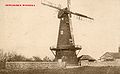 Newchurch pre 1906.jpg 1,583 × 971; 483 KB
-
 Newchurch Tower Mill (2) - geograph.org.uk - 2088378.jpg 3,072 × 2,304; 1.88 MB
-
 Newchurch Tower Mill - geograph.org.uk - 2088372.jpg 3,072 × 2,304; 928 KB
-
 Newchurch Village Hall (2) - geograph.org.uk - 2150711.jpg 3,072 × 2,304; 1.95 MB
-
 Newchurch Village Hall - geograph.org.uk - 2150708.jpg 3,072 × 2,304; 1.53 MB
-
 Newchurch village sign - geograph.org.uk - 3397128.jpg 3,000 × 4,000; 4.07 MB
-
 Newchurch, St. Peter and St. Pauls' church from the west - geograph.org.uk - 4799443.jpg 3,678 × 2,456; 6.04 MB
-

-
 Newly constructed building, Will’s Farm, Wills Lane - geograph.org.uk - 5235803.jpg 3,208 × 2,448; 1.96 MB
-
 Nissen hut on Romney Marsh - geograph.org.uk - 3554515.jpg 640 × 480; 95 KB
-
 Norwood Farm - geograph.org.uk - 2151861.jpg 3,072 × 2,304; 1.85 MB
-
 Norwood Farm Caravan Park - geograph.org.uk - 2151842.jpg 3,072 × 2,304; 2.09 MB
-
 Norwood Lane at Popton Bridge - geograph.org.uk - 3554504.jpg 640 × 480; 85 KB
-
 Old hedgerow alongside Gammon's Farm Lane - geograph.org.uk - 2055761.jpg 1,280 × 960; 646 KB
-
 Old Village Hall, Newchurch - geograph.org.uk - 2171736.jpg 3,072 × 2,304; 2.44 MB
-
 Ordnance Survey Cut Mark - geograph.org.uk - 4889878.jpg 4,000 × 3,000; 4.32 MB
-
 Pickneybush Lane - geograph.org.uk - 2055776.jpg 1,280 × 960; 647 KB
-
 Pickneybush Lane - geograph.org.uk - 2574280.jpg 2,256 × 1,496; 892 KB
-
 Pink Clouds over New Barn Farm - geograph.org.uk - 2153644.jpg 3,072 × 1,728; 1.05 MB
-
 Ploughed field - geograph.org.uk - 4792441.jpg 640 × 426; 61 KB
-
 Pylons in the mist - geograph.org.uk - 384701.jpg 480 × 640; 69 KB
-
 Rare Stained Glass, St Peter and St Paul Church - geograph.org.uk - 2574365.jpg 1,416 × 1,102; 1.07 MB
-
 Red berries in drainage channel - geograph.org.uk - 2153480.jpg 3,072 × 2,304; 2.12 MB
-
 Remains of a Looker’s Hut, Blackmanstone Bridge - geograph.org.uk - 4737326.jpg 3,264 × 2,448; 3.98 MB
-
 Road junction, St Mary's Rd - geograph.org.uk - 4798957.jpg 640 × 426; 52 KB
-
 Road sign, St Mary's Rd - geograph.org.uk - 4798958.jpg 640 × 426; 63 KB
-
 Road to Newchurch - geograph.org.uk - 2574319.jpg 1,905 × 1,420; 2.22 MB
-
 Roadside Memorial near Newchurch - geograph.org.uk - 2574294.jpg 1,600 × 1,061; 793 KB
-
 Romney Marsh sunset - with power pylon - geograph.org.uk - 5845603.jpg 746 × 1,024; 54 KB
-
 Romney Marsh view near Tatnam Bridge - geograph.org.uk - 2049142.jpg 1,280 × 960; 606 KB
-
 Rookelands Farm - geograph.org.uk - 1944408.jpg 1,024 × 768; 238 KB
-
 Ruined building near Norwood Farm - geograph.org.uk - 2151852.jpg 3,072 × 2,304; 1.78 MB
-
 Sewer off St Mary's Road - geograph.org.uk - 2574679.jpg 2,055 × 1,491; 2.21 MB
-
 Sheaty Sewer - geograph.org.uk - 5315342.jpg 640 × 480; 122 KB
-
 Sheds on Romney Marsh - geograph.org.uk - 5315305.jpg 640 × 480; 120 KB
-


_-_geograph.org.uk_-_3196896.jpg)


_-_geograph.org.uk_-_408596.jpg)


_-_geograph.org.uk_-_2088378.jpg)

_-_geograph.org.uk_-_2150711.jpg)


