Category:Nieder-Wöllstädter Straße 10
Jump to navigation
Jump to search
| Object location | | View all coordinates using: OpenStreetMap |
|---|
This is the category of the Hessian Kulturdenkmal (cultural monument) with the ID 6983 (Wikidata)
|
| Upload media | |||||
| Instance of | |||||
|---|---|---|---|---|---|
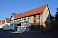
| Location | Rodheim vor der Höhe, Rosbach vor der Höhe, Wetteraukreis, Darmstadt Government Region, Hesse, Germany | ||||
| Heritage designation | |||||
 | |||||
Media in category "Nieder-Wöllstädter Straße 10"
The following 2 files are in this category, out of 2 total.
-
 Rodheim vor der Höhe, Nieder-Wöllstädter Straße 10, Tor.JPG 2,576 × 4,124; 6.04 MB
-
 Rodheim vor der Höhe, Nieder-Wöllstädter Straße 10.JPG 4,273 × 2,821; 6.45 MB

