Category:Nieuwe Plantage 58
Jump to navigation
Jump to search
| Object location | | View all coordinates using: OpenStreetMap |
|---|
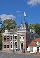
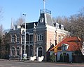
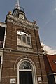
villa in Delft, Netherlands  | |||||
| Upload media | |||||
| Instance of | |||||
|---|---|---|---|---|---|
| Location | Delft, South Holland, Netherlands | ||||
| Street address |
| ||||
| Heritage designation |
| ||||
| Inception |
| ||||
 | |||||
|
This is a category about rijksmonument number 525310
|
| Address |
|
Media in category "Nieuwe Plantage 58"
The following 6 files are in this category, out of 6 total.
-
 Delft Nieuwe Plantage 58.jpg 4,000 × 5,744; 13.54 MB
-
 Delft-Villa Vrijenban.jpg 1,320 × 1,132; 1.32 MB
-
 Exterieur OVERZICHT - Delft - 20290624 - RCE.jpg 1,191 × 1,200; 297 KB
-
 Nieuwe Plantage 58.jpg 1,950 × 1,536; 1.5 MB
-
 Overzicht voorgevel - Delft - 20382166 - RCE.jpg 1,200 × 956; 274 KB
-
 Villa Vrijenban, Delft.jpg 2,336 × 3,504; 3.25 MB


