Category:Nij Brongergea Tsjerke
Jump to navigation
Jump to search
| Object location | | View all coordinates using: OpenStreetMap |
|---|
church  | |||||
| Upload media | |||||
| Instance of | |||||
|---|---|---|---|---|---|
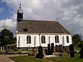
| Location | De Knipe, Heerenveen, Friesland, Netherlands | ||||
| Street address |
| ||||
| Located on street |
| ||||
| Heritage designation |
| ||||
| Inception |
| ||||
| Religion or worldview | |||||
| official website | |||||
 | |||||
Nederlands: Nij Brongergea Tsjerke, De Knipe
|
This is a category about rijksmonument number 21174
|
| Address |
|
Media in category "Nij Brongergea Tsjerke"
The following 16 files are in this category, out of 16 total.
-
 2023 De Knipe, Nij Brongergea Tsjerke.jpg 2,020 × 1,348; 846 KB
-
 De Knipe, Nij Brongergea Tsjerke.jpg 4,380 × 3,131; 5.16 MB
-
 Exterieur - De Knipe - 20030445 - RCE.jpg 1,200 × 1,200; 256 KB
-
 Exterieur - De Knipe - 20126085 - RCE.jpg 1,200 × 955; 249 KB
-
 Exterieur, gevelsteen in zuidgevel - De Knipe - 20030451 - RCE.jpg 1,188 × 1,200; 468 KB
-
 Herfoarme tsjerke De Knipe 2009.JPG 3,264 × 2,448; 2.03 MB
-
 Ingangspartij noordgevel - De Knipe - 20030450 - RCE.jpg 948 × 1,200; 461 KB
-
 Interieur - De Knipe - 20126086 - RCE.jpg 1,200 × 954; 178 KB
-
 Interieur - De Knipe - 20126087 - RCE.jpg 1,200 × 950; 175 KB
-
 Interieur, naar het oosten - De Knipe - 20030453 - RCE.jpg 1,200 × 967; 171 KB
-
 Interieur, naar het westen - De Knipe - 20030452 - RCE.jpg 954 × 1,200; 162 KB
-
 Interieur, preekstoel en orgel - De Knipe - 20030454 - RCE.jpg 953 × 1,200; 163 KB
-
 Noordgevel - De Knipe - 20030447 - RCE.jpg 1,200 × 949; 220 KB
-
 Zuid-oostgevel - De Knipe - 20030449 - RCE.jpg 1,200 × 955; 229 KB
-
 Zuid-westgevel - De Knipe - 20030446 - RCE.jpg 948 × 1,200; 187 KB
-
 Zuidgevel - De Knipe - 20030448 - RCE.jpg 1,200 × 951; 214 KB


