Category:Nikolaikirche (Prenzlau)
Jump to navigation
Jump to search
| Object location | | View all coordinates using: OpenStreetMap |
|---|
 | |||||
| Upload media | |||||
| Instance of | |||||
|---|---|---|---|---|---|
| Location | Prenzlau, Uckermark District, Brandenburg, Germany | ||||
| Heritage designation | |||||
 | |||||
This is the category of the Brandenburger Baudenkmal (cultural heritage monument) with the ID 09130111 (Wikidata)
|
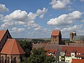
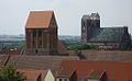
Deutsch: Der Turm der ehemaligen St. Nikolaikirche in Prenzlau, Mark Brandenburg, ist alles was blieb, nachdem die mit der Reformation geschlossene Kirche 1769 abgerissen wurde. Die Kirche entstand Mitte des 13. Jahrhunderts.
English: The tower of the formerly St. Nicholas' Church in Prenzlau, March of Brandenburg, Germany, is all what remained after the church, which had been closed since Reformation, was torn down in 1769. The church was erected in the mid-13th c.
Media in category "Nikolaikirche (Prenzlau)"
The following 10 files are in this category, out of 10 total.
-
 20130824 xl wiki 4917-Windkraftanlagen-ueber-den-Daechern-von-Prenzlau.jpg 4,000 × 3,000; 2.41 MB
-
 2022-06-07 Prenzlau 08.jpg 4,608 × 3,456; 6.37 MB
-
 2022-06-07 Prenzlau 09.jpg 4,608 × 3,456; 6.36 MB
-
 Alte Nikolaikirche in Prenzlau 01.jpg 2,736 × 3,648; 2.04 MB
-
 Alte Nikolaikirche in Prenzlau 02.jpg 2,736 × 3,648; 1.33 MB
-
 Alte Nikolaikirche in Prenzlau 03.jpg 2,736 × 3,648; 1.99 MB
-
 Geburtsstadt - mein foto.jpg 1,024 × 629; 447 KB
-
 Nikolaikirche (Ruine) Prenzlau.jpg 4,928 × 3,264; 976 KB
-
 Nikolaikirche Prenzlau.JPG 1,200 × 1,600; 388 KB
-
 Schulzenstraße Nikolaikirche Prenzlau.jpg 3,264 × 4,928; 986 KB


_Prenzlau.jpg)


Categories:
- Churches in Prenzlau
- Cultural heritage monuments in Prenzlau
- Saint Nicholas churches in Brandenburg
- Ruins of churches in Brandenburg
- Fieldstone churches in Brandenburg
- Gothic churches in Brandenburg
- Brick Gothic church towers in Germany
- 13th-century churches in Brandenburg
- Brick Gothic church towers in Brandenburg