Category:Noordeinde 42B, The Hague
Jump to navigation
Jump to search
| Object location | | View all coordinates using: OpenStreetMap |
|---|
 | |||||
| Upload media | |||||
| Instance of | |||||
|---|---|---|---|---|---|
| Location | The Hague, South Holland, Netherlands | ||||
| Street address |
| ||||
| Heritage designation |
| ||||
 | |||||
|
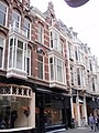
This is a category about rijksmonument number 17832
|
| Address |
|
Media in category "Noordeinde 42B, The Hague"
The following 11 files are in this category, out of 11 total.
-
 Exterieur - 's-Gravenhage - 20089408 - RCE.jpg 962 × 1,200; 268 KB
-
 Exterieur - 's-Gravenhage - 20089409 - RCE.jpg 1,200 × 947; 279 KB
-
 Interieur bakkerij - 's-Gravenhage - 20089417 - RCE.jpg 1,200 × 960; 247 KB
-
 Interieur lunchroom - 's-Gravenhage - 20089414 - RCE.jpg 1,200 × 956; 222 KB
-
 Interieur lunchroom - 's-Gravenhage - 20089415 - RCE.jpg 1,200 × 950; 221 KB
-
 Interieur lunchroom - 's-Gravenhage - 20089416 - RCE.jpg 950 × 1,200; 223 KB
-
 Interieur winkel - 's-Gravenhage - 20089410 - RCE.jpg 1,200 × 953; 232 KB
-
 Interieur winkel - 's-Gravenhage - 20089412 - RCE.jpg 951 × 1,200; 209 KB
-
 Interieur winkel, plafond - 's-Gravenhage - 20089413 - RCE.jpg 1,200 × 957; 223 KB
-
 Rm17832.JPG 2,736 × 3,648; 1.96 MB
-
 Winkel interieur - 's-Gravenhage - 20089411 - RCE.jpg 1,200 × 951; 234 KB


