Category:Northwich
跳转到导航
跳转到搜索
英格兰城镇  | |||||
| 上传媒体 | |||||
| 隶属于 | |||||
|---|---|---|---|---|---|
| 位置 | 西柴郡與切斯特, 柴郡, 西北英格蘭, 英格兰 | ||||
| 取代對象 |
| ||||
| 官方网站 | |||||
 | |||||
子分类
本分类有以下9个子分类,共有9个子分类。
B
L
- Lostock Power Station (8 F)
N
- Northwich Motive Power Depot (13 F)
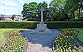
- Northwich War Memorial (2 F)
P
S
- Sir John Deane's College (3 F)
T
W
分类“Northwich”中的媒体文件
以下200个文件属于本分类,共216个文件。
(上一页)(下一页)-

-
 A Fine Nautical Vessel - panoramio.jpg 1,024 × 768;708 KB
-
 A glimpse of the Weaver ... - geograph.org.uk - 5048640.jpg 3,648 × 2,432;3.97 MB
-
 A556 crossing River Weaver - geograph.org.uk - 4440975.jpg 640 × 246;33 KB
-

-
 A559 Chester Road at Beach Road - geograph.org.uk - 5436206.jpg 640 × 480;62 KB
-
 Aboard the Edwin Clark on the River Weaver - geograph.org.uk - 5191089.jpg 6,000 × 4,000;4.66 MB
-
-
 Anderton Nature Park - geograph.org.uk - 4957362.jpg 2,000 × 1,505;1.1 MB
-
 Ashton Flash - geograph.org.uk - 2907620.jpg 1,600 × 1,200;275 KB
-
 Basin Arm Bridge No 188 - geograph.org.uk - 4817751.jpg 800 × 514;128 KB
-

-

-

-

-

-

-
 Building alongside the Weaver Navigation - geograph.org.uk - 6215808.jpg 1,024 × 768;216 KB
-

-
 Carey Park - geograph.org.uk - 5827354.jpg 1,024 × 768;230 KB
-
 Chemical works, Winnington - geograph.org.uk - 5150767.jpg 1,024 × 768;141 KB
-
 Chester Way in Northwich - geograph.org.uk - 4802705.jpg 800 × 535;128 KB
-
 Chester Way looking east - geograph.org.uk - 2533026.jpg 640 × 480;63 KB
-

-
 Christmas Day, Northwich (5306453841).jpg 4,320 × 3,240;6.94 MB
-
 Christmas Day, Northwich (5307042460).jpg 4,320 × 3,240;7.98 MB
-

-
-
 Control room, Town Swingbridge, Northwich - geograph.org.uk - 5159868.jpg 1,024 × 768;176 KB
-
 Country lane (2273938347).jpg 2,048 × 1,536;2.59 MB
-
 Cricket ground, Northwich - geograph.org.uk - 5223447.jpg 1,024 × 683;289 KB
-
 Cut mark on ^195 Chester Rd, Northwich - geograph.org.uk - 5117832.jpg 1,024 × 768;219 KB
-
 Dane Valley Cemetery (2) - geograph.org.uk - 2696998.jpg 3,072 × 2,304;3.22 MB
-
 Death Valley-former salt lagoon with struggling saplings - geograph.org.uk - 1773357.jpg 3,072 × 2,304;1.26 MB
-
-

-
-

-

-

-

-

-
 Down by the River - panoramio.jpg 1,024 × 768;937 KB
-
 Eastern section, Tata Chemicals Europe site - geograph.org.uk - 5185969.jpg 1,024 × 768;130 KB
-
 End of the line - geograph.org.uk - 1773355.jpg 3,072 × 2,304;1.63 MB
-
 Fence Post - panoramio.jpg 1,024 × 768;676 KB
-
 Field by the River - panoramio.jpg 1,024 × 768;676 KB
-
 Fields (5312225146).jpg 3,872 × 2,592;7.11 MB
-
 Flickr - ronsaunders47 - ALPACAS AND JACOB SHEEP..jpg 3,072 × 2,304;2.36 MB
-
 Flickr - ronsaunders47 - DONKEYS AT THE CRAFT FAIR...jpg 3,072 × 2,304;2.15 MB
-
 Floating pennywort, west bank, River Weaver - geograph.org.uk - 5159798.jpg 1,024 × 614;147 KB
-

-
 Footbridge over Witton Brook - geograph.org.uk - 4957377.jpg 2,000 × 1,360;1.08 MB
-
 Footpath bridge near Northwich - geograph.org.uk - 6219102.jpg 640 × 420;81 KB
-
 Footpath heading North into the Dane Valley - geograph.org.uk - 2697007.jpg 3,072 × 2,304;4.41 MB
-
 Frosty (2273941807).jpg 2,048 × 1,536;2.39 MB
-
 Frosty (2274727552).jpg 2,048 × 1,536;1.87 MB
-
 Frozen (2274738522).jpg 2,048 × 1,536;2.61 MB
-
 Gated road, Northwich - geograph.org.uk - 2601500.jpg 640 × 480;72 KB
-
 Gateway to Carey Park - geograph.org.uk - 871732.jpg 640 × 480;301 KB
-
 Greenbank - geograph.org.uk - 6246649.jpg 6,000 × 3,212;1.9 MB
-
 Greenbank Station - geograph.org.uk - 5207508.jpg 640 × 437;397 KB
-
 Greenbank Station - geograph.org.uk - 5207912.jpg 451 × 640;396 KB
-
 Heron on the Trent ^ Mersey Canal - geograph.org.uk - 4817723.jpg 800 × 771;218 KB
-
 Hollands Road, Northwich - geograph.org.uk - 2980157.jpg 640 × 480;105 KB
-

-
 Kennel Wood - panoramio.jpg 3,456 × 4,608;6.52 MB
-
 Landing swan (166652788).jpg 3,456 × 2,298;3.19 MB
-
 Malpas Road, Northwich - geograph.org.uk - 5541298.jpg 1,280 × 851;430 KB
-
 Marshalls Arm - geograph.org.uk - 76481.jpg 640 × 480;130 KB
-
 Moored boats, west bank, River Weaver - geograph.org.uk - 5160436.jpg 1,024 × 768;147 KB
-

-
 Moreton Street, Winnington - geograph.org.uk - 5540705.jpg 1,280 × 851;444 KB
-
 Moss Farm Leisure Complex, Northwich.JPG 4,608 × 3,456;3.48 MB
-
 Moss Road - geograph.org.uk - 2533048.jpg 640 × 479;129 KB
-
 Mr Mik's and Maggie's - geograph.org.uk - 5541850.jpg 1,280 × 853;293 KB
-
 Mum and Holly (1745333069).jpg 3,872 × 2,592;8.52 MB
-

-

-

-
 New building off Weaver Way, Northwich - geograph.org.uk - 5159831.jpg 1,024 × 768;138 KB
-

-
 North bank, Barnton Cut, Weaver Navigation - geograph.org.uk - 5149974.jpg 1,024 × 768;133 KB
-
 Northern end, Tata Chemicals Europe - geograph.org.uk - 5187473.jpg 1,024 × 614;121 KB
-
 Northwich (29592698514).jpg 4,000 × 3,000;2.93 MB
-
 Northwich (29926523240).jpg 4,000 × 3,000;2.09 MB
-
 Northwich (30107913512).jpg 4,000 × 3,000;2.91 MB
-
 Northwich (5327383029).jpg 4,815 × 1,080;2.53 MB
-
 Northwich (5329666634).jpg 4,033 × 2,184;4.59 MB
-
 Northwich (7548015630).jpg 3,612 × 2,271;8 MB
-
 Northwich - geograph.org.uk - 6246585.jpg 6,000 × 3,439;2.03 MB
-
 Northwich - urban sculpture - geograph.org.uk - 940843.jpg 640 × 480;93 KB
-
 Northwich Community Woodlands - Bicycle feature - geograph.org.uk - 5621963.jpg 5,184 × 2,920;5.47 MB
-
 Northwich Community Woodlands - geograph.org.uk - 5827342.jpg 1,024 × 768;220 KB
-
 Northwich from the air - geograph.org.uk - 3946628.jpg 640 × 480;184 KB
-
 Northwich from the Park (NBY 439133).jpg 3,600 × 2,350;2.32 MB
-
 Northwich in minus 11 (5308558221).jpg 3,632 × 1,080;2.22 MB
-
 Northwich in minus 11 (5308558849).jpg 4,912 × 1,080;2.62 MB
-
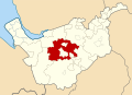
 Northwich in vale royal.png 591 × 443;97 KB
-
 Northwich Library - geograph.org.uk - 5541468.jpg 1,280 × 850;414 KB
-
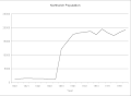 Northwich population.gif 726 × 530;4 KB
-
 Northwich Repair Yard - geograph.org.uk - 2425552.jpg 640 × 488;71 KB
-
 Northwich Rural District, Cheshire (1970).svg 1,410 × 1,018;385 KB
-
 Northwich Urban District, Cheshire (1970).svg 1,410 × 1,018;385 KB
-
 Northwich winter (5374449529).jpg 3,688 × 2,557;4.24 MB
-
 Northwich, Tesco - geograph.org.uk - 5263611.jpg 1,024 × 735;149 KB
-
 Path under the A556 dual carriageway - geograph.org.uk - 4804890.jpg 800 × 564;154 KB
-

-

-
 Pipeline, east bank, River Weaver, Northwich - geograph.org.uk - 5159836.jpg 1,024 × 768;158 KB
-
 Pipelines at the Tata Chemicals Europe site - geograph.org.uk - 5185910.jpg 1,024 × 615;134 KB
-

-
 Pollution (5312222166).jpg 2,592 × 3,872;3.87 MB
-
 Postles Place, Northwich - geograph.org.uk - 2980150.jpg 640 × 480;104 KB
-
 Public Art, at Victoria Bridge - geograph.org.uk - 1297749.jpg 619 × 449;66 KB
-
 Railway viaduct crossing London Road - geograph.org.uk - 4802719.jpg 800 × 558;124 KB
-

-
 Reflection (1745501793).jpg 3,872 × 2,592;7.78 MB
-
 River Dane - geograph.org.uk - 433942.jpg 640 × 480;104 KB
-
 River Dane at Northwich (1).JPG 4,608 × 3,456;3.4 MB
-
 River Weaver - geograph.org.uk - 3119091.jpg 640 × 481;671 KB
-
 River Weaver - geograph.org.uk - 3119102.jpg 640 × 481;474 KB
-
 River Weaver from Hayhurst Bridge, Northwich.JPG 4,320 × 3,240;2.68 MB
-
 River Weaver from Town Bridge, Northwich.JPG 4,608 × 3,456;3.44 MB
-
 River Weaver from Winnington Bridge - geograph.org.uk - 3119104.jpg 640 × 480;247 KB
-
 River Weaver old channel - geograph.org.uk - 804443.jpg 640 × 426;191 KB
-
 River Weaver, upstream of Hunt's Lock No 2 - geograph.org.uk - 5160432.jpg 1,024 × 768;115 KB
-
 Roadway on former salt works - geograph.org.uk - 1773344.jpg 3,072 × 2,304;1.43 MB
-

-
 Shopping trolley (1744929629).jpg 3,872 × 2,592;9.95 MB
-
 Site of Air Training Corps Depot - geograph.org.uk - 2980151.jpg 640 × 480;92 KB
-

-
 Solvay Road in Winnington - geograph.org.uk - 4802666.jpg 800 × 575;113 KB
-
 Solvay Road, Winnington - geograph.org.uk - 5541017.jpg 1,280 × 850;532 KB
-
 St. Helen Witton churchyard - geograph.org.uk - 5966597.jpg 1,024 × 768;275 KB
-
 St. Helen Witton parish church - geograph.org.uk - 5966591.jpg 1,024 × 768;170 KB
-
 Statue of Sir John Brunner - geograph.org.uk - 1241816.jpg 480 × 640;101 KB
-
 Steam pipeline in Carey Park - geograph.org.uk - 3673099.jpg 1,600 × 1,200;385 KB
-

-
 Stile and footpath into the Dane valley (2) - geograph.org.uk - 2697002.jpg 3,072 × 2,304;3.86 MB
-
 Stile and footpath into the Dane valley - geograph.org.uk - 2696999.jpg 3,072 × 2,304;4.86 MB
-

-

-

-
-

-

-
 Tata Chemicals and the Anderton boat lift - geograph.org.uk - 5191055.jpg 6,000 × 4,000;4.52 MB
-
-
 TATA Chemicals Europe Ltd - geograph.org.uk - 6219110.jpg 640 × 427;67 KB
-
 Tata Chemicals Winnington Plant - geograph.org.uk - 4961491.jpg 2,000 × 1,333;1.25 MB
-
 Terraces, James Street, Northwich - geograph.org.uk - 5828314.jpg 1,024 × 768;215 KB
-
 The A533 in Kingsmead - geograph.org.uk - 4803501.jpg 800 × 475;137 KB
-
 The Anderton Rifle Range - geograph.org.uk - 1805146.jpg 4,000 × 3,000;2.93 MB
-

-
 The Bowling Green - geograph.org.uk - 4803387.jpg 800 × 456;114 KB
-

-
 The lime beds (1746280778).jpg 3,872 × 2,592;6.35 MB
-
 The Postal Service bench, Northwich.JPG 3,240 × 4,320;4.05 MB
-
 The River Weaver in Northwich - geograph.org.uk - 4802689.jpg 800 × 510;151 KB
-
 The River Weaver in Winnington - geograph.org.uk - 4802483.jpg 800 × 525;111 KB
-

-

-
 The Trent ^ Mersey Canal - geograph.org.uk - 4386213.jpg 6,000 × 4,000;3.51 MB
-
 Town Bridge in Northwich - geograph.org.uk - 4802680.jpg 800 × 516;115 KB
-
 Town Bridge, Northwich - geograph.org.uk - 5966616.jpg 1,600 × 901;218 KB
-

-
 Trent ^ Mersey Canal towpath at Northwich - geograph.org.uk - 5185971.jpg 1,024 × 768;451 KB
-
 Trent ^ Mersey Canal, near Lostock Gralam - geograph.org.uk - 5542734.jpg 1,280 × 851;466 KB
-
 Trying to break through (5312223390).jpg 3,872 × 2,592;5.12 MB
-
 Vapour trail (2274732942).jpg 2,048 × 1,536;1.9 MB
-

-
 Victoria Road Primary School - geograph.org.uk - 5827767.jpg 1,024 × 768;125 KB
-
 Victoria Road, Northwich - geograph.org.uk - 5827770.jpg 1,024 × 768;169 KB
-
 View from the lime beds (1746317562).jpg 3,872 × 2,592;7.99 MB
-

-
 View towards Watling Street bridge - geograph.org.uk - 4957392.jpg 2,000 × 1,455;1.32 MB
-
 Wallerstote Ash Works, Northwich - geograph.org.uk - 4835469.jpg 1,600 × 1,067;298 KB
-
 War memorial in Northwich - geograph.org.uk - 4802714.jpg 800 × 502;210 KB
-
 Wasteland (1745168871).jpg 3,872 × 2,592;3.78 MB
-
 Wasteland (1745399307).jpg 3,872 × 2,592;7.02 MB
-
 Watkin abandoned shopping trolley (496376984).jpg 2,048 × 1,536;854 KB
-
 Watkin broken sign (496377030).jpg 2,048 × 1,536;828 KB
-
 Weaver Hall Museum and Workhouse - geograph.org.uk - 4803377.jpg 800 × 577;121 KB
-
 Weaver Navigation - geograph.org.uk - 4961459.jpg 2,000 × 1,333;1.47 MB
-
 Weaver Navigation - geograph.org.uk - 6246570.jpg 5,999 × 3,725;1.71 MB
-
 Weaver Navigation - geograph.org.uk - 6246573.jpg 5,948 × 3,416;1.81 MB
-
 Weaver Navigation - geograph.org.uk - 6247558.jpg 6,000 × 4,000;1.76 MB
-

-
 Weaver Navigation at Winnington - geograph.org.uk - 5150764.jpg 1,024 × 614;101 KB
-
 Weed (1745526547).jpg 3,872 × 2,592;5.32 MB
-
 Weir (1746111034).jpg 3,872 × 2,592;8.62 MB
-
 Weird sun (2487550058).jpg 3,872 × 2,592;3.35 MB
-
 Western section, Tata Chemicals Europe - geograph.org.uk - 5187470.jpg 1,024 × 768;120 KB
-
 Wharf crane, Navigation Yard, Northwich - geograph.org.uk - 5159889.jpg 1,024 × 768;158 KB
-
 Wild plant (1745550959).jpg 3,872 × 2,592;5.12 MB
-

-
 Winding wheel sculpture, Northwich (1).JPG 4,608 × 3,456;3.55 MB
-
 Winding wheel sculpture, Northwich (2).JPG 4,608 × 3,456;3.52 MB
-
 Winnington - Northwich footpath 12 - geograph.org.uk - 861206.jpg 640 × 480;261 KB


.jpg)
.jpg)


.jpg)


_-_geograph.org.uk_-_2696998.jpg)

_-_geograph.org.uk_-_5149933.jpg)
_-_geograph.org.uk_-_5149937.jpg)
_-_geograph.org.uk_-_5149940.jpg)
_-_geograph.org.uk_-_5149946.jpg)
_-_geograph.org.uk_-_5149949.jpg)
_-_geograph.org.uk_-_5149958.jpg)
_-_geograph.org.uk_-_5149963.jpg)


.jpg)


.jpg)
.jpg)
.jpg)


.jpg)


.jpg)


.jpg)
.jpg)
.jpg)
.jpg)
.jpg)


.jpg)


.svg)
.svg)
.jpg)


.jpg)


.jpg)

.JPG)


.jpg)


_-_geograph.org.uk_-_2697002.jpg)


.jpg)


.jpg)
.jpg)


.jpg)


.jpg)
.jpg)
.jpg)
.jpg)


.jpg)
.jpg)
.jpg)


.jpg)

.JPG)
.JPG)

.jpg)
.jpg)
.jpg)