Category:Nîmes St Eugénie church
Jump to navigation
Jump to search
| Object location | | View all coordinates using: OpenStreetMap |
|---|
|
This building is inscrit au titre des monuments historiques de la France. It is indexed in the base Mérimée, a database of architectural heritage maintained by the French Ministry of Culture, under the reference PA30000077
|
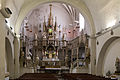
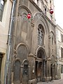
chapel located in Gard, in France   | |||||
| Upload media | |||||
| Instance of | |||||
|---|---|---|---|---|---|
| Location | Nîmes, arrondissement of Nîmes, Gard, Occitania, Metropolitan France, France | ||||
| Street address |
| ||||
| Owned by |
| ||||
| Heritage designation |
| ||||
| official website | |||||
 | |||||
Media in category "Nîmes St Eugénie church"
The following 46 files are in this category, out of 46 total.
-
 Chapelle st-eugenie nimes 01.JPG 2,736 × 3,648; 2.49 MB
-
 Chapelle st-eugenie nimes 02.JPG 2,211 × 3,421; 2.63 MB
-
 NimesChapelleSteEugenie 01.jpg 4,016 × 6,016; 16.09 MB
-
 NimesChapelleSteEugenie 02.jpg 5,764 × 3,842; 14.71 MB
-
 Nîmes Chapel of St Eugénie door.jpg 4,008 × 6,008; 19.12 MB
-
 Nîmes Chapel of St Eugénie.jpg 4,008 × 6,008; 13.61 MB
-
 Nîmes,Ste Eugénie00.jpg 2,669 × 2,070; 1.25 MB
-
 Nîmes,Ste Eugénie01.jpg 2,607 × 2,086; 1.19 MB
-
 Nîmes,Ste Eugénie02.jpg 2,112 × 2,641; 1.18 MB
-
 Nîmes,Ste Eugénie03.jpg 2,640 × 2,112; 1.23 MB
-
 Nîmes,Ste Eugénie04.jpg 2,640 × 2,112; 1.27 MB
-
 Nîmes,Ste Eugénie05.jpg 2,602 × 2,082; 1.08 MB
-
 Nîmes,Ste Eugénie06.jpg 2,112 × 2,640; 1.2 MB
-
 Nîmes,Ste Eugénie07.jpg 2,641 × 2,112; 1.14 MB
-
 Nîmes,Ste Eugénie08.jpg 2,621 × 2,097; 1.25 MB
-
 Nîmes,Ste Eugénie09.jpg 2,052 × 2,566; 970 KB
-
 Nîmes,Ste Eugénie10.jpg 2,084 × 2,605; 986 KB
-
 Nîmes,Ste Eugénie11.jpg 2,609 × 2,087; 1.27 MB
-
 Nîmes,Ste Eugénie12.jpg 2,640 × 2,112; 1.18 MB
-
 Nîmes,Ste Eugénie13.jpg 2,112 × 2,639; 1.29 MB
-
 Nîmes,Ste Eugénie14.jpg 2,086 × 2,608; 1 MB
-
 Nîmes,Ste Eugénie15.jpg 2,112 × 2,641; 965 KB
-
 Nîmes,Ste Eugénie16.jpg 2,112 × 2,641; 909 KB
-
 Nîmes,Ste Eugénie17.jpg 2,112 × 2,641; 1.04 MB
-
 Nîmes,Ste Eugénie18.jpg 1,925 × 2,406; 732 KB
-
 Nîmes,Ste Eugénie19.jpg 2,574 × 2,059; 1.13 MB
-
 Nîmes,Ste Eugénie20.jpg 1,981 × 2,476; 773 KB
-
 Nîmes,Ste Eugénie21.jpg 2,796 × 1,571; 921 KB
-
 Nîmes,Ste Eugénie22.jpg 3,072 × 1,728; 1.05 MB
-
 Nîmes,Ste Eugénie23.jpg 2,112 × 2,640; 741 KB
-
 Nîmes,Ste Eugénie24.jpg 1,981 × 2,477; 761 KB
-
 Nîmes,Ste Eugénie25.jpg 2,110 × 2,748; 889 KB
-
 Nîmes,Ste Eugénie26.jpg 2,112 × 2,640; 1.15 MB
-
 Nîmes,Ste Eugénie27.jpg 2,515 × 2,012; 695 KB
-
 Nîmes,Ste Eugénie28.jpg 2,112 × 2,639; 973 KB
-
 Nîmes,Ste Eugénie29.jpg 2,112 × 2,640; 1.03 MB
-
 Nîmes,Ste Eugénie30.jpg 2,611 × 2,088; 1.12 MB
-
 Nîmes,Ste Eugénie31.jpg 2,612 × 2,089; 1.11 MB
-
 Nîmes,Ste Eugénie32.jpg 2,701 × 1,517; 594 KB
-
 Nîmes,Ste Eugénie33.jpg 1,917 × 1,129; 367 KB
-
 Nîmes-Chapelle Sainte Eugènie-Chœur-20150601.jpg 5,472 × 3,648; 9.72 MB
-
 Nîmes-Chapelle Sainte Eugènie-Ostensoir-20150601.jpg 5,472 × 3,648; 11.12 MB
-
 Saint Eugenie chapel in Nimes 01.jpg 3,294 × 4,561; 9.24 MB
-
 Saint Eugenie chapel in Nimes 02.jpg 3,925 × 2,730; 6.21 MB
-
 Saint Eugenie chapel in Nimes 03.jpg 2,248 × 4,880; 6.63 MB
-
 Sainte-Eugénie Nîmes.JPG 2,448 × 3,264; 1.54 MB


