Category:Obere Brauhausgasse 3 (Höchstadt an der Aisch)
Jump to navigation
Jump to search
| Object location | | View all coordinates using: OpenStreetMap |
|---|
This is the category of the Bavarian Baudenkmal (cultural heritage monument) with the ID D-5-72-135-60 (Wikidata)
|
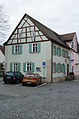
Deutsch: Höchstadt an der Aisch - Obere Brauhausgasse 3 - Wohnhaus. Zweigeschossiger traufständiger Satteldachbau mit Fachwerkgiebel, um 1840/50.
building in Höchstadt an der Aisch, Middle Franconia, Germany  | |||||
| Upload media | |||||
| Instance of | |||||
|---|---|---|---|---|---|
| Location | Höchstadt an der Aisch, Erlangen-Höchstadt, Middle Franconia, Bavaria, Germany | ||||
| Street address |
| ||||
| Heritage designation | |||||
 | |||||
Media in category "Obere Brauhausgasse 3 (Höchstadt an der Aisch)"
The following 2 files are in this category, out of 2 total.
-
 Höchstadt an der Aisch, Obere Brauhausgasse 3, 001.jpg 3,264 × 4,928; 8.03 MB
-
 Höchstadt an der Aisch, Obere Brauhausgasse 3, 002.jpg 3,264 × 4,928; 8.04 MB
