Category:Ocean currents
Pereiti į navigaciją
Jump to search

continuous flow of ocean water   | |||||
| Įkelti mediją | |||||
| Tarimas (garso failas) | |||||
|---|---|---|---|---|---|
| Poklasis |
| ||||
| Yra dalis | |||||
| |||||
Subkategorijos
Rodoma 13 subkategorijų (iš viso yra 13 subkategorijų).
Daugialypės terpės rinkmenos kategorijoje „Ocean currents“
Šioje kategorijoje yra viena rinkmena.
-
 2007 floater-release hg.jpg 1 578 × 2 322; 681 KiB
-
 A56 SouthGeorgia vir 2016153 Iceberg lrg.jpg 4 272 × 3 336; 4,62 MiB
-
 Amoc-index.svg 1 000 × 500; 129 KiB
-
 ATL-LLWBCs-labelled.jpg 2 212 × 2 226; 290 KiB
-
 BrnBldRcm8.jpg 612 × 650; 77 KiB
-
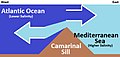 Camarinal Sill Water Mixing (Simplified).jpg 536 × 256; 34 KiB
-
 Canaryislands tmo 2013166 lrg(2).jpg 2 600 × 2 000; 1 006 KiB
-
 Carte generale des principaux courants marin en 1910.jpg 859 × 571; 103 KiB
-
Circulation of Ocean Currents Around the Western Antarctic Ice Shelves.ogv 30 s, 1 280 × 720; 71,25 MiB
-
 Coastal currents along the Atlantic coast of the United States (1942) (20035163774).jpg 3 634 × 1 586; 800 KiB
-
 Coastal currents along the Atlantic coast of the United States (1942) (20035207064).jpg 4 056 × 1 882; 984 KiB
-
 Coastal currents along the Atlantic coast of the United States (1942) (20035219664).jpg 2 862 × 1 532; 563 KiB
-
 Coastal currents along the Atlantic coast of the United States (1942) (20036909893).jpg 2 960 × 1 550; 682 KiB
-
 Coastal currents along the Atlantic coast of the United States (1942) (20469786660).jpg 3 810 × 1 802; 780 KiB
-
 Coastal currents along the Atlantic coast of the United States (1942) (20469786728).jpg 3 640 × 1 602; 783 KiB
-
 Coastal currents along the Atlantic coast of the United States (1942) (20470999019).jpg 3 634 × 1 636; 828 KiB
-
 Coastal currents along the Atlantic coast of the United States (1942) (20664463331).jpg 3 548 × 1 678; 689 KiB
-
 Columbia Glacier (Alaska) by Sentinel-2 cropped.jpg 5 550 × 5 880; 9,88 MiB
-
 Corriente de Benguela-png.png 1 366 × 625; 1,45 MiB
-
 Corriente de California-Feb-13-2013-20.jpg 640 × 455; 77 KiB
-
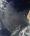 Corriente de las Canarias y tormenta de arena 1.jpg 5 428 × 6 424; 3,1 MiB
-

-
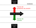 Dibujo Corrientes geostróficas.png 1 844 × 1 454; 88 KiB
-
 Dibujo Corrientes geostróficas.svg 744 × 1 052; 7 KiB
-
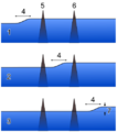
 Diurnal Flow over a Ridge - NOAA-PMEL.gif 295 × 357; 4,2 MiB
-
 Downwelling NADW.svg 798 × 661; 48 KiB
-
 East Australian Current.jpg 2 060 × 2 900; 1,75 MiB
-

-
 Ekman meter.jpg 700 × 523; 81 KiB
-
 Enrgy1.jpg 490 × 276; 31 KiB
-
 Esquema corrents equatorials.png 922 × 1 026; 105 KiB
-
 Expl2360 - Flickr - NOAA Photo Library.jpg 3 888 × 2 592; 1,28 MiB
-
 Famous rock - panoramio.jpg 4 160 × 3 120; 2,25 MiB
-
 FMIB 36682 Courants Marins de l'Ete Boreal.jpeg 1 528 × 1 097; 491 KiB
-
 FMIB 36712 Courant Polaire Arctique.jpeg 1 498 × 891; 368 KiB
-
 FMIB 36720 Courants Marins de l'Hiver Boreal.jpeg 1 528 × 1 097; 482 KiB
-
 FMIB 53209 Drague a courant.jpeg 160 × 424; 34 KiB
-
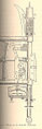 FMIB 53210 Mesureur de courant d'Ekman.jpeg 188 × 570; 42 KiB
-
 Foggy Peruvian Valleys.jpg 2 899 × 3 306; 10,05 MiB
-
 Geostrophic current 1 NT.PNG 480 × 480; 37 KiB
-
 Geostrophic current 2 NT.PNG 450 × 510; 33 KiB
-
 Globpop.gif 1 341 × 730; 465 KiB
-
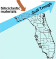 Gulf Trough dipiction.png 375 × 400; 87 KiB
-
 Ind-LLWBCs-labelled.jpg 2 188 × 2 224; 356 KiB
-
 Islas de Cabo Verde.jpg 5 014 × 3 598; 3,29 MiB
-
 Katrina vs sea surface height.jpg 1 194 × 917; 219 KiB
-
 Leaking path.jpg 800 × 600; 31 KiB
-
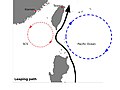 Leaping path.jpg 800 × 600; 30 KiB
-
 Looping path.jpg 800 × 600; 34 KiB
-
 Meandros en el océano.jpg 427 × 268; 40 KiB
-
 Naruto Whirlpools taken 4-21-2008.jpg 3 456 × 2 304; 6,61 MiB
-
 New-5c-20visual 39980594.png 1 600 × 1 092; 473 KiB
-
 No- Ekmanspiralen.jpg 595 × 600; 160 KiB
-
 Nordatlantik.jpg 4 555 × 3 974; 7,33 MiB
-
 North Atlantic Temp Section 30N.gif 649 × 560; 21 KiB
-
 North equatorial currents.jpg 720 × 540; 40 KiB
-
 Numerical simulations of the response of intense ocean currents to atmospheric forcing. (IA numericalsimulat00adam).pdf 1 189 × 1 550, 112 puslapių; 5,36 MiB
-
 Ocean bottom (contour) current.webp 2 135 × 1 174; 824 KiB
-
Ocean flows at surface and 2000 meters below sea level.webm 1 min 14 s, 1 920 × 1 080; 81,29 MiB
-
 Oceanmotion driftmodel-Jan.png 700 × 420; 34 KiB
-
 Oceanmotion driftmodel-Mar.png 700 × 420; 33 KiB
-
 Oyashio SST 11mai.png 717 × 773; 38 KiB
-
 Oyashio SST.png 717 × 773; 53 KiB
-
 Pacific NEC.png 1 008 × 720; 150 KiB
-
Perpetual Ocean.ogv 3 min 2 s, 960 × 540; 28,76 MiB
-
 Recording Current Meter.jpg 507 × 1 844; 349 KiB
-
 S2004341153052.L2 HCHL.MalvinasCurrent.jpg 2 711 × 3 117; 1,76 MiB
-
 SeaSurfaceTopography Atlantic.gif 534 × 671; 38 KiB
-
 South Atlantic Ocean currents 1943 for colorblind users.png 999 × 647; 913 KiB
-
 Stiller ozean.jpg 4 555 × 3 956; 7,07 MiB
-
Streamfunction 0.5x0.5 veros 275 years.webm 16 s, 1 024 × 688; 11,6 MiB
-
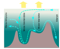
 Termohalinni vymenik.gif 507 × 297; 5 KiB
-
 The California Current System (25198382355).jpg 8 000 × 8 000; 16,96 MiB
-

-

-

-
 The seasonality of the NEC in Atlantic.png 864 × 720; 105 KiB
-
 The seasonality of the NEC in Indian Ocean.png 864 × 1 080; 222 KiB
-
Thermohaline conveyor belt (NASA).webm 1 min 23 s, 1 280 × 720; 21,9 MiB
-
 Von Karman Vortex Baja California Isla Guadalupe 1.jpg 2 239 × 2 008; 727 KiB
-
 Wind and wave forcing of longshore currents across a barred beach. (IA windwaveforcingo00whit).pdf 1 187 × 1 566, 238 puslapiai; 12,8 MiB


.jpg)
.jpg)

_(20035163774).jpg)
_(20035207064).jpg)
_(20035219664).jpg)
_(20036909893).jpg)
_(20469786660).jpg)
_(20469786728).jpg)
_(20470999019).jpg)
_(20664463331).jpg)
_by_Sentinel-2_cropped.jpg)


_current.webp)


.jpg)
_and_El_Nino_(1997)_years.png)
_and_El_Nino_(1997)_years.png)
_and_El_Nino_(1997)_years.png)


