Category:Osmaston Saw Mill
Jump to navigation
Jump to search
| Camera location | | View all coordinates using: OpenStreetMap |
|---|
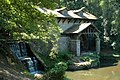
Grade II* listed sawmill on Osmaston Manor estate, Shirley, Derbyshire Dales, England  | |||||
| Upload media | |||||
| Instance of | |||||
|---|---|---|---|---|---|
| Location | Shirley, Derbyshire Dales, Derbyshire, East Midlands, England | ||||
| Has use | |||||
| Heritage designation |
| ||||
| Different from | |||||
 | |||||
Media in category "Osmaston Saw Mill"
The following 13 files are in this category, out of 13 total.
-
 Dam and Waterwheel, Shirley, Derbyshire.jpg 3,264 × 1,952; 2.32 MB
-
 Mill in Osmaston Park - geograph.org.uk - 3611819.jpg 800 × 533; 157 KB
-
 Osmaston Mill - geograph.org.uk - 724446.jpg 640 × 426; 119 KB
-
 Osmaston Saw Mill - geograph.org.uk - 1240870.jpg 640 × 480; 98 KB
-
 Osmaston Saw Mill - geograph.org.uk - 1240874.jpg 640 × 480; 79 KB
-
 Osmaston Saw Mill - geograph.org.uk - 1240877.jpg 640 × 480; 93 KB
-
 Osmaston Saw Mill 2022-02-07 09-17-04.jpg 4,160 × 3,120; 2.99 MB
-
 Osmaston Saw Mill 2022-02-07 09-17-05.jpg 4,160 × 3,120; 3.49 MB
-
 Osmaston Saw Mill 2022-02-07 09-17-06.jpg 4,160 × 3,120; 3.53 MB
-
 Osmaston Saw Mill 2022-02-07 09-17-07.jpg 3,120 × 4,160; 3.41 MB
-
 Osmaston Saw Mill 2022-02-07 09-17-08.jpg 4,160 × 3,120; 3.51 MB
-
 Restored saw mill at Shirley Park - geograph.org.uk - 3626693.jpg 3,950 × 2,156; 6.71 MB
-
 The Old Mill, Osmaston Park - geograph.org.uk - 77576.jpg 640 × 480; 67 KB


