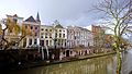
Category:Oudegracht 47, Utrecht
Jump to navigation
Jump to search
| Object location | | View all coordinates using: OpenStreetMap |
|---|
house in Utrecht, Netherlands  | |||||
| Upload media | |||||
| Instance of | |||||
|---|---|---|---|---|---|
| Location | Utrecht, Netherlands | ||||
| Street address |
| ||||
| Located on street | |||||
| Heritage designation |
| ||||
 | |||||
|
This is a category about rijksmonument number 36492
|
| Address |
|
Media in category "Oudegracht 47, Utrecht"
The following 6 files are in this category, out of 6 total.
-
 Breedstraatbuurt, Utrecht, Netherlands - panoramio (2).jpg 2,048 × 1,155; 524 KB
-
 Chueca-utrecht-2010.jpg 1,600 × 1,204; 1.69 MB
-
 Kalff-utrecht.jpg 1,000 × 739; 818 KB
-
 Oudegracht1963-RozeWolk.jpg 1,200 × 807; 502 KB
-
 Overzicht voorgevels - Utrecht - 20236450 - RCE.jpg 1,200 × 807; 205 KB
-
 Rijksmonument36492.JPG 1,920 × 2,560; 981 KB
.jpg)


