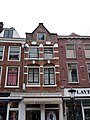
Category:Oudkerkhof 6, Utrecht
Jump to navigation
Jump to search
| Object location | | View all coordinates using: OpenStreetMap |
|---|
 | |||||
| Upload media | |||||
| Instance of |
| ||||
|---|---|---|---|---|---|
| Location | Utrecht, Netherlands | ||||
| Street address |
| ||||
| Heritage designation |
| ||||
 | |||||
|
This is a category about rijksmonument number 18287
|
|
This is a category about rijksmonument number 18288
|
| Address |
|
Media in category "Oudkerkhof 6, Utrecht"
The following 6 files are in this category, out of 6 total.
-
 Exterieur VOORGEVEL - Utrecht - 20305908 - RCE.jpg 786 × 1,200; 216 KB
-
 Exterieur VOORGEVEL, ZIJGEVEL - Utrecht - 20305909 - RCE.jpg 783 × 1,200; 234 KB
-
 Exterieur VOORGEVELS - Utrecht - 20305910 - RCE.jpg 788 × 1,200; 204 KB
-
 Oudkerkhof 6a.JPG 2,592 × 3,456; 3.83 MB
-
 Oudkerkhof 6b.JPG 2,592 × 3,456; 3.43 MB
-
 Voorgevels - Utrecht - 20236859 - RCE.jpg 806 × 1,200; 161 KB


