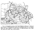
Category:Ozark Mountains
Vai alla navigazione
Vai alla ricerca
- The Ozark Mountains—Ozarks — mountain range and dissected plateau in Arkansas, Kansas, Missouri, and Oklahoma.
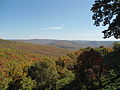
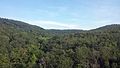
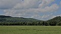
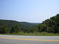
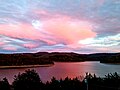
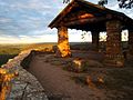
regione degli Stati Uniti d'America  View of the Ozarks from the Buffalo National River, Newton County, Arkansas | |||||
| Carica un file multimediale | |||||
| Istanza di | |||||
|---|---|---|---|---|---|
| Parte di | |||||
| Materiale usato | |||||
| Luogo | |||||
| Larghezza |
| ||||
| Lunghezza |
| ||||
| Superficie |
| ||||
| Altezza sul mare |
| ||||
 | |||||
Sottocategorie
Questa categoria contiene le 12 sottocategorie indicate di seguito, su un totale di 12.
Pagine nella categoria "Ozark Mountains"
Questa categoria contiene un'unica pagina, indicata di seguito.
File nella categoria "Ozark Mountains"
Questa categoria contiene 110 file, indicati di seguito, su un totale di 110.
-
 A beautiful scene on Current River in the Ozarks (79270).jpg 3 303 × 2 100; 2,88 MB
-
 A destitute family, Ozark Mountains area, Arkansas, 8a16384.jpg 4 092 × 2 744; 3,84 MB
-
 A destitute family, Ozark Mountains area, Arkansas, 8a16384.tif 4 282 × 3 006; 24,57 MB
-
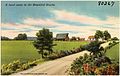 A rural scene in the beautiful Ozarks (80267).jpg 3 264 × 2 080; 2,73 MB
-
 A typical float scene in the scenic Ozarks (78185).jpg 3 300 × 2 070; 2,89 MB
-
 Arkansas and Missouri Railroad 001.jpg 1 974 × 2 968; 2,52 MB
-
 Arkansas and Missouri Railroad 002.jpg 2 014 × 3 033; 2,83 MB
-
 Arkansas Nuclear One cooling tower.jpg 3 648 × 2 736; 5,57 MB
-
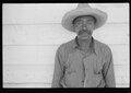
 Arkansas sharecropper, 8a16804a.jpg 4 147 × 2 767; 4,2 MB
-
 Arkansas sharecropper, 8a16804a.tif 4 336 × 3 055; 25,29 MB
-
 Artist's Point, AR.JPG 4 000 × 3 000; 5,07 MB
-
 Beech on the River (13170981894).jpg 2 400 × 1 600; 1,78 MB
-
 Big Sugar Creek.jpg 425 × 290; 47 KB
-
 Boston Mountains 001.jpg 4 128 × 2 322; 4,68 MB
-
 Boston Mountains 002.jpg 4 128 × 2 322; 4,16 MB
-
 Boston Mountains. Looking East on Gaither Mountain.jpg 10 304 × 4 010; 3,14 MB
-
 Boxley Valley 001.jpg 2 984 × 1 996; 2,22 MB
-
 Boxley Valley 002.jpg 2 611 × 3 911; 3,44 MB
-
 Boxley Valley 003.jpg 3 167 × 2 112; 1,82 MB
-
 Boxley Valley 004.jpg 3 000 × 2 004; 2,04 MB
-
 Buffalo River Outcrops (13170963854).jpg 2 400 × 1 600; 1,15 MB
-
 Buffalo River trail.jpg 2 160 × 2 880; 1,71 MB
-
 Buffalo River, AR (13170712135).jpg 2 400 × 1 600; 1,57 MB
-
 Bulletin - Biological Survey (1908) (19808465003).jpg 3 080 × 2 080; 2,76 MB
-
 Canebrake (13170822213).jpg 2 400 × 1 600; 1,65 MB
-
 Destitute tenant farmer's family, Ozark Mountains, Arkansas, 8a16361.jpg 4 104 × 2 726; 4,18 MB
-
 Destitute tenant farmer's family, Ozark Mountains, Arkansas, 8a16361.tif 4 288 × 3 030; 24,81 MB
-
 Entering Noel, Mo., the Price Drive of the Ozarks, U.S. Highway 71 (78308).jpg 3 306 × 2 064; 2,85 MB
-
 Fall in the Ozarks.jpg 5 202 × 3 463; 17,71 MB
-
 Fence Lizard (13170757493).jpg 1 926 × 1 285; 664 KB
-
 Fishing is always good in the Ozarks (80266).jpg 3 309 × 2 108; 3,17 MB
-
 Frog Pond (13170932084).jpg 2 400 × 1 600; 1,92 MB
-
 Fuzzybutt Falls.jpg 3 312 × 4 968; 9,95 MB
-
 Gfp-arkansas-mount-magazine-state-park-the-ozark-valley.jpg 3 253 × 2 194; 1,48 MB
-
 Gulf Coastal Plains and Ozarks LCC (14037139560).jpg 4 000 × 2 248; 2,11 MB
-
 Ha Ha Tonka Spring on Lake of the Ozarks.jpg 1 872 × 416; 1,05 MB
-
 Hepatica Bloom (13170939304).jpg 1 512 × 2 274; 551 KB
-
 Highway 5, 9 and 14 in Mountain View, AR 002.jpg 4 128 × 2 322; 2,79 MB
-
 Highway 5, 9 and 14 in Mountain View, AR 003.jpg 4 128 × 2 322; 2,8 MB
-
 Highway 66 overlook near Mountain View, AR.jpg 2 820 × 1 761; 703 KB
-
 Highway 66, between Waynesville and Rolla, Missouri in the beautiful Ozarks (79681).jpg 3 291 × 2 073; 2,9 MB
-
 Home in the Ozark Mountains, Colp Arkansas (7977385274).jpg 448 × 315; 59 KB
-
 I-540 and US 71 run in Fayetteville.jpg 3 413 × 2 174; 1,04 MB
-
 I-540 near Winslow, Arkansas.jpg 2 272 × 1 704; 912 KB
-
 Interior of Ozark school, Arkansas, 8a16468.jpg 3 916 × 2 739; 3,62 MB
-
 Interior of Ozark school, Arkansas, 8a16468.tif 4 291 × 3 052; 25 MB
-
 John Vachon, Ozark children getting mail from RFD box, Missouri, 1940.jpg 3 598 × 2 524; 1,26 MB
-
 Lake Fort Smith 001.jpg 3 000 × 2 000; 7,48 MB
-
 Level IV ecoregions, Nebraska and Kansas.pdf 6 654 × 5 264; 3,36 MB
-
 Looking out into the Ozark forest from the Bluff Shelter.jpg 3 888 × 2 592; 4,45 MB
-
 Lower Boston Mountains near Marshall, AR.jpg 3 887 × 2 187; 789 KB
-
 Meadowcreek Sign.jpg 122 × 100; 4 KB
-
 Mina Sauk Falls.jpg 1 852 × 3 216; 3,14 MB
-
 Misty Bluff along the Buffalo River.jpg 3 072 × 2 304; 1,73 MB
-
 Misty mountains.JPG 2 048 × 1 536; 224 KB
-
 Mount Sequoyah and Fayetteville from University of Arkansas.jpg 4 000 × 3 000; 4,29 MB
-
 Native Dogwood in the beautiful Ozarks (80268).jpg 3 299 × 2 089; 2,9 MB
-
 Natural Dam, Arkansas 002.jpg 3 455 × 1 944; 908 KB
-
 Nuberscher Ozark Landscape 1920.jpg 400 × 308; 46 KB
-
 Nuderscher nocturn.jpg 844 × 840; 184 KB
-
 October Ozark Woodlands.jpg 1 600 × 1 200; 1,14 MB
-
 Ouachitas II (13157570275).jpg 1 724 × 1 600; 376 KB
-
 Ozark Bluffs (13170643145).jpg 1 600 × 2 374; 1,53 MB
-
 Ozark Cliffs (13170772513).jpg 2 400 × 1 600; 2,2 MB
-
 Ozark Folk Center.png 143 × 163; 41 KB
-
 Ozark Highlands ecoregion, Level III.png 244 × 185; 40 KB
-
 Ozark Highlands Scenic Byway 002.jpg 2 570 × 3 870; 3,21 MB
-
 Ozark Mountains farmer and family, Missouri, 8c17559.jpg 12 842 × 9 510; 43,8 MB
-
 Ozark Mountains farmer and family, Missouri, 8c17559.tif 13 917 × 10 767; 142,93 MB
-
 Ozark Mtn Stream (13170917124).jpg 2 400 × 1 600; 1,81 MB
-
 Ozark Pool (13170696425).jpg 3 089 × 1 600; 2,03 MB
-
 Ozark Seep (13170907034).jpg 2 400 × 1 600; 1,81 MB
-
 Ozark Stream (13170689525).jpg 2 400 × 1 600; 1,97 MB
-
 Ozark Trail completed sections w relief v3.jpg 1 214 × 924; 812 KB
-
 Ozark Trail Jan2009 relief map v3.jpg 2 217 × 1 529; 1,08 MB
-
 Ozark-Folk-Center2.jpg 200 × 110; 33 KB
-
 OzarkRelief.jpg 800 × 658; 167 KB
-
 Ozarks Highlands of Missouri.png 523 × 474; 186 KB
-
 Ozarks.jpg 2 560 × 1 920; 927 KB
-
 Pink Skies - Flickr - Drew de F Fawkes.jpg 12 000 × 9 000; 17,6 MB
-
 Scenic Lookout on White Rock Mountain.jpg 1 024 × 768; 487 KB
-
 Shelter on White Rock Mountain.jpg 3 072 × 2 304; 1,34 MB
-
 Snawfus Breathing.jpg 987 × 660; 691 KB
-
 Snawfus Leaping.jpg 720 × 1 080; 1,15 MB
-
 Snawfus.jpg 2 100 × 1 586; 833 KB
-
 South Fork river at Kia Kima Scout Reservation.jpg 4 032 × 3 024; 3,31 MB
-
 Spring Peeper at Rest (13170680995).jpg 2 400 × 1 600; 721 KB
-
 Spring Peeper Calling.jpg 2 252 × 1 501; 816 KB
-
 Sunset from Reed Mountain.jpg 2 544 × 1 676; 889 KB
-
 Theb1618 - Flickr - NOAA Photo Library.jpg 776 × 1 388; 327 KB
-
 U.S. Highway 71, the Prize Drive of the Ozarks, near Noel, Mo (78307).jpg 3 288 × 2 056; 3,09 MB
-
 U.S. Highway 71, the Prize Drive of the Ozarks, near Noel, Mo (78309).jpg 2 123 × 3 284; 3,17 MB
-
 University of Arkansas Campus 03.jpg 895 × 596; 121 KB
-
 University of Arkansas Campus 06.jpg 1 180 × 786; 155 KB
-
 US 62 and US 412 in Mountain Home.jpg 3 184 × 2 123; 1,65 MB
-
 View from Mount Magazine.JPG 3 648 × 2 736; 3,95 MB
-
 View from Taum Sauk Mountain Lookout Tower.JPG 3 648 × 2 736; 4,09 MB
-
 View from White Rock Mountain.jpg 4 277 × 2 835; 8,38 MB
-

-

-
 Walton College in the Ozark Mountains.jpg 5 248 × 2 952; 2,38 MB
-
 White River, famous for float trips, in the beautiful Ozarks (79277).jpg 3 301 × 2 053; 2,81 MB
-
 White Rock Mountain overlook 001.jpg 4 128 × 2 322; 2,26 MB
-
 White Rock Mountain overlook 002.jpg 4 128 × 2 322; 2,62 MB
-
 White Rock Mountain overlook 003.jpg 2 322 × 4 128; 2,43 MB
-
 White Rock Mountain overlook 004.jpg 4 128 × 2 322; 2,26 MB
-
 White Rock Mountain.jpg 4 264 × 2 824; 8,4 MB
-
 White Rock SM.jpg 800 × 533; 138 KB
-
 Wild Azaleas in beautiful Ozarks (79500).jpg 2 111 × 3 303; 3,05 MB
-
 Camassia scilloides Ozarks.jpg 1 328 × 2 000; 596 KB
.jpg)

.jpg)
.jpg)


.jpg)


.jpg)

.jpg)
_(19808465003).jpg)
.jpg)

.jpg)

.jpg)
.jpg)
.jpg)


.jpg)
.jpg)


.jpg)
.jpg)


.jpg)


.jpg)
.jpg)
.jpg)


.jpg)
.jpg)
.jpg)
.jpg)


.jpg)


.jpg)
.jpg)


.jpg)


.jpg)
