Category:Pakhuis Gelderland (Schiedam)
Jump to navigation
Jump to search
| Object location | | View all coordinates using: OpenStreetMap |
|---|
 | |||||
| Upload media | |||||
| Instance of | |||||
|---|---|---|---|---|---|
| Location | Schiedam, South Holland, Netherlands | ||||
| Street address |
| ||||
| Located on street | |||||
| Heritage designation |
| ||||
 | |||||
|
This is a category about rijksmonument number 33216
|
| Address |
|
Media in category "Pakhuis Gelderland (Schiedam)"
The following 31 files are in this category, out of 31 total.
-
 Detail wapensteen in voorgevel - Schiedam - 20429450 - RCE.jpg 800 × 1,200; 280 KB
-
 GraphyArchy - Wikipedia 00342.jpg 3,000 × 2,000; 6.35 MB
-
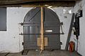
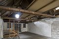
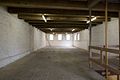
 Interieur begane grond, dubbele deur - Schiedam - 20429443 - RCE.jpg 1,200 × 800; 142 KB
-
 Interieur begane grond, dubbele deur - Schiedam - 20429444 - RCE.jpg 1,200 × 800; 150 KB
-

-
-
-
-

-
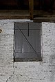
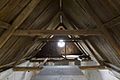 Interieur derde verdieping, kapconstructie - Schiedam - 20429439 - RCE.jpg 1,200 × 800; 164 KB
-
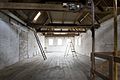
 Interieur derde verdieping, keulse goot - Schiedam - 20429440 - RCE.jpg 1,200 × 800; 173 KB
-
 Interieur derde verdieping, keulse goot - Schiedam - 20429441 - RCE.jpg 800 × 1,200; 170 KB
-
 Interieur derde verdieping, keulse goot - Schiedam - 20429442 - RCE.jpg 1,200 × 800; 171 KB
-
-

-

-

-
-
-
 Overzicht Lange Haven - Schiedam - 20342578 - RCE.jpg 1,200 × 1,200; 281 KB
-
 Overzicht met kerk - Schiedam - 20196558 - RCE.jpg 1,200 × 959; 224 KB
-
 Overzicht over de Lange Haven - Schiedam - 20002937 - RCE.jpg 1,188 × 1,200; 322 KB
-
 Overzicht van de voorgevel - Schiedam - 20429446 - RCE.jpg 800 × 1,200; 285 KB
-
 Overzicht van de voorgevel - Schiedam - 20429447 - RCE.jpg 800 × 1,200; 314 KB
-
 Overzicht van de voorgevel - Schiedam - 20429448 - RCE.jpg 800 × 1,200; 328 KB
-
 Overzicht van de voorgevel - Schiedam - 20429449 - RCE.jpg 800 × 1,200; 296 KB
-
 Overzicht voorgevels van pakhuizen - Schiedam - 20382002 - RCE.jpg 1,200 × 1,200; 309 KB
-
 Schiedam - Lange Haven 46.jpg 1,944 × 2,592; 1.91 MB
-
 Schiedam Lange Haven 46-50.jpg 4,008 × 6,008; 22.01 MB
-
 Schiedam, Netherlands - panoramio (42).jpg 2,048 × 1,148; 621 KB
-
 Voorgevels - Schiedam - 20196819 - RCE.jpg 1,200 × 791; 189 KB


.jpg)
