Category:Pelsestraat 7, Heusden
Jump to navigation
Jump to search
| Object location | | View all coordinates using: OpenStreetMap |
|---|
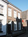
building in Heusden, Netherlands  | |||||
| Upload media | |||||
| Instance of | |||||
|---|---|---|---|---|---|
| Location | Heusden, North Brabant, Netherlands | ||||
| Street address |
| ||||
| Located on street | |||||
| Heritage designation |
| ||||
 | |||||
Stoeppaal met ketting:
|
This is a category about rijksmonument number 22067
|
Pand:
|
This is a category about rijksmonument number 22070
|
| Address |
|
Media in category "Pelsestraat 7, Heusden"
The following 8 files are in this category, out of 8 total.
-
 Achtergevel - Heusden - 20112061 - RCE.jpg 966 × 1,200; 298 KB
-
 Heusden - Pelsestraat 7 - Stoeppaal.JPG 2,592 × 3,888; 6.01 MB
-
 Heusden - Pelsestraat 7 Woonhuis met stoeppalen.JPG 2,592 × 3,888; 5.67 MB
-
 Heusden - Pelsestraat 7.jpg 1,944 × 2,592; 1.22 MB
-
 T.T Stoeppaal Pelsestraat to 7 Heusden 22067 (1).JPG 3,072 × 4,608; 4.53 MB
-
 T.T Stoeppaal Pelsestraat to 7 Heusden 22067 (2).JPG 3,072 × 4,608; 4.73 MB
-
 Voorgevels - Heusden - 20112033 - RCE.jpg 802 × 1,200; 185 KB
-
 Zijgevel - Heusden - 20112062 - RCE.jpg 956 × 1,200; 239 KB


.JPG)
.JPG)

