Category:Pentalina (ship, 2008)
Zur Navigation springen
Zur Suche springen
| Informationen über Pentalina können unter IMO 9437969 gefunden werden. Ein Schiff kann manchmal seinen Namen und seine Flagge ändern, aber die IMO-Nummer am Schiffsrumpf bleibt immer gleich. Daher ist es sinnvoll, ein Schiff anhand seiner IMO-Nummer zu identifizieren. |
Wikimedia-Kategorie | |||||
| Medium hochladen | |||||
| Ist ein(e) | |||||
|---|---|---|---|---|---|
| Kategorie kombiniert die Themen | |||||
| Pentalina | |||||
Fähre der schottischen Reederei Pentland Ferries  | |||||
| Ist ein(e) | |||||
| Rufzeichen |
| ||||
| Baunummer |
| ||||
| Land des Schiffsregistereintrags | |||||
| Inbetriebnahme |
| ||||
| Bruttoraumzahl |
| ||||
| Länge |
| ||||
| |||||
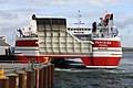
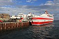
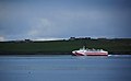
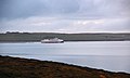
MV Pentalina is a 70m RoPax catamaran ferry purchased by Pentland Ferries in 2008 to operate between Gills Bay, Caithness and St Margaret's Hope, Orkney.
Medien in der Kategorie „Pentalina (ship, 2008)“
Folgende 38 Dateien sind in dieser Kategorie, von 38 insgesamt.
-
 "MV Pentalina" entering Gill's Bay - geograph.org.uk - 5637464.jpg 640 × 480; 54 KB
-
 230207 Pentalina from Beacon Arts Centre, Greenock.jpg 3.829 × 2.272; 1,63 MB
-
 All Lined Up - geograph.org.uk - 2460480.jpg 1.232 × 1.936; 1,7 MB
-

-
 Car ferry Pentalina - geograph.org.uk - 2243930.jpg 640 × 480; 101 KB
-
 Easy does it...... - geograph.org.uk - 3099277.jpg 800 × 534; 264 KB
-
 Ferry to Orkney from Gits.jpg 3.280 × 2.464; 2,11 MB
-
 Foreshore at St Margaret's Hope - geograph.org.uk - 1300561.jpg 640 × 427; 98 KB
-
 Harbour at Gills Bay - geograph.org.uk - 3585829.jpg 3.872 × 2.592; 2,68 MB
-
 Here comes the Pentalina^ - geograph.org.uk - 3099268.jpg 800 × 535; 268 KB
-
 Leaving Gills Bay - geograph.org.uk - 3470168.jpg 640 × 480; 90 KB
-
 Leaving Gills Bay - geograph.org.uk - 3547658.jpg 640 × 457; 249 KB
-
 Loading the MV Pentalina - geograph.org.uk - 4465031.jpg 640 × 480; 484 KB
-

-
 MV 'Pentalina' - geograph.org.uk - 5813968.jpg 640 × 412; 292 KB
-
 MV Pentalina - geograph.org.uk - 3470104.jpg 640 × 480; 77 KB
-
 MV Pentalina at St Margaret's Hope - geograph.org.uk - 1453622.jpg 640 × 428; 71 KB
-
 MV Pentalina coming into Gills Bay - geograph.org.uk - 4465024.jpg 640 × 480; 444 KB
-
-
 MV Pentalina reversing into Gills Bay - geograph.org.uk - 3592913.jpg 3.872 × 2.592; 3,3 MB
-
 Pentalina - geograph.org.uk - 1340854.jpg 640 × 480; 58 KB
-
-
 Pentalina crop.jpg 1.024 × 768; 138 KB
-
 Pentalina rounding Croo Taing, Hoxa - geograph.org.uk - 1314307.jpg 640 × 395; 28 KB
-

-
 Pentalina.jpg 595 × 344; 30 KB
-
 Pentilena heading to Orkney - geograph.org.uk - 2221863.jpg 640 × 482; 68 KB
-
 Pentland Ferries.jpg 3.264 × 1.836; 1,75 MB
-
 Pentland Ferry from Hunda Reef - panoramio.jpg 1.418 × 886; 1,1 MB
-
 Ship Pentalina 01.jpg 4.080 × 3.072; 4,46 MB
-
 St. Margaret's Hope ferry pier. - geograph.org.uk - 1510742.jpg 640 × 492; 139 KB
-
 Stand by to open the doors....... - geograph.org.uk - 3099308.jpg 800 × 534; 248 KB
-
 The Pentalina - geograph.org.uk - 3264269.jpg 1.500 × 906; 961 KB
-
 The pier, Gills Bay - geograph.org.uk - 4067395.jpg 2.567 × 1.531; 1,07 MB
-
 The wake of the Pentalina - geograph.org.uk - 4474622.jpg 640 × 480; 367 KB
-
 The wake of the Pentalina - geograph.org.uk - 4475059.jpg 640 × 480; 356 KB
-
 Waiting to disembark the MV Pentalina - geograph.org.uk - 4465028.jpg 640 × 480; 403 KB
-
 WK98 (19928034068).jpg 5.760 × 3.840; 13,55 MB


.jpg)