Category:Pestfriedhof Böbing
Jump to navigation
Jump to search
This is the category of the Bavarian Baudenkmal (cultural heritage monument) with the ID D-1-90-117-5 (Wikidata)
|
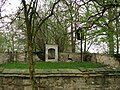
Deutsch: Pestfriedhof südlich von Böbing; Anlage mit Ummauerung, Bildstock und Grabkreuzen ab Mitte 17. Jh.
| Object location | | View all coordinates using: OpenStreetMap |
|---|
 | |||||
| Upload media | |||||
| Instance of | |||||
|---|---|---|---|---|---|
| Location | Böbing, Weilheim-Schongau, Upper Bavaria, Bavaria, Germany | ||||
| Street address |
| ||||
| Heritage designation | |||||
 | |||||
Media in category "Pestfriedhof Böbing"
The following 3 files are in this category, out of 3 total.
-
 Pestfriedhof Böbing GO-1.jpg 2,592 × 1,944; 1.9 MB
-
 Pestfriedhof Böbing GO-2.jpg 2,592 × 1,944; 1.86 MB
-
 Pestfriedhof Böbing GO-3.jpg 2,592 × 1,944; 1.62 MB

