Category:Plantage Lepellaan 5, Amsterdam
Jump to navigation
Jump to search
| Object location | | View all coordinates using: OpenStreetMap |
|---|
 | |||||
| Upload media | |||||
| Instance of | |||||
|---|---|---|---|---|---|
| Part of | |||||
| Location | Plantage, Amsterdam-Centrum, Amsterdam, North Holland, Netherlands | ||||
| Street address |
| ||||
| Located on street |
| ||||
| Heritage designation |
| ||||
| Inception |
| ||||
 | |||||
|
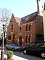
This is a category about rijksmonument number 518269
|
| Address |
|
Media in category "Plantage Lepellaan 5, Amsterdam"
The following 5 files are in this category, out of 5 total.
-
 Koetshuis en koetsierswoning van stadsvillacomplex.JPG 2,172 × 2,276; 1.47 MB
-
 Plantage lepellaan 5.JPG 2,304 × 3,072; 1.57 MB
-
 Stadsvillacomplex 4.JPG 4,000 × 3,000; 4.13 MB
-
 Stadsvillacomplex 5.jpg 3,000 × 4,000; 4.05 MB
-
 Tuinhek stadsvillacomplex (3).JPG 2,620 × 2,184; 1.79 MB


.JPG)