Category:Polstraat 15, Deventer
Jump to navigation
Jump to search
| Object location | | View all coordinates using: OpenStreetMap |
|---|
building in Deventer, Netherlands  | |||||
| Upload media | |||||
| Instance of | |||||
|---|---|---|---|---|---|
| Location | Deventer, Overijssel, Netherlands | ||||
| Street address |
| ||||
| Located on street | |||||
| Heritage designation |
| ||||
 | |||||
|
This is a category about rijksmonument number 12749
|
| Address |
|
Media in category "Polstraat 15, Deventer"
The following 8 files are in this category, out of 8 total.
-
-

-
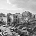
 Overzicht achtergevels - Deventer - 20056418 - RCE.jpg 1,186 × 1,200; 251 KB
-
 Overzicht achtergevels - Deventer - 20056436 - RCE.jpg 1,195 × 1,200; 298 KB
-
 Overzicht achtergevels - Deventer - 20056440 - RCE.jpg 1,186 × 1,200; 277 KB
-
 Overzicht achtergevels - Deventer - 20056441 - RCE.jpg 1,195 × 1,200; 281 KB
-
 Polstraat 15-43.JPG 2,304 × 3,072; 3.41 MB
-
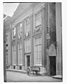 Voorgevel - Deventer - 20056427 - RCE.jpg 958 × 1,200; 162 KB
_-_Deventer_-_20281337_-_RCE.jpg)
_-_Deventer_-_20354877_-_RCE.jpg)


