Category:Polstraat 62, Deventer
Jump to navigation
Jump to search
| Object location | | View all coordinates using: OpenStreetMap |
|---|
building in Deventer, Netherlands  | |||||
| Upload media | |||||
| Instance of | |||||
|---|---|---|---|---|---|
| Location | Deventer, Overijssel, Netherlands | ||||
| Street address |
| ||||
| Located on street | |||||
| Heritage designation |
| ||||
 | |||||
|
This is a category about rijksmonument number 12768
|
| Address |
|
Media in category "Polstraat 62, Deventer"
The following 9 files are in this category, out of 9 total.
-
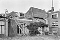 Achterzijde - Deventer - 20056480 - RCE.jpg 1,200 × 808; 264 KB
-
 Met muur - Deventer - 20056481 - RCE.jpg 1,200 × 808; 313 KB
-
 Overzicht - Deventer - 20056497 - RCE.jpg 1,200 × 963; 216 KB
-
 Overzicht gevels - Deventer - 20056498 - RCE.jpg 1,200 × 959; 237 KB
-
 Polstraat 62.JPG 2,304 × 3,072; 4.26 MB
-
 Polstraat nabij Melksterstraat - Deventer - 20054097 - RCE.jpg 1,195 × 1,200; 245 KB
-
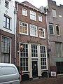
 Voorgevel - Deventer - 20056482 - RCE.jpg 808 × 1,200; 175 KB
-
 Voorgevel - Deventer - 20056483 - RCE.jpg 816 × 1,200; 199 KB
-
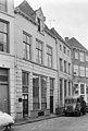
 Voorgevels - Deventer - 20056479 - RCE.jpg 1,200 × 812; 262 KB


