Category:Portland, Dorset
Jump to navigation
Jump to search
civil parish in Dorset, England, UK | |||||
| Upload media | |||||
| Instance of | |||||
|---|---|---|---|---|---|
| Location | Dorset, South West England, England | ||||
| Different from | |||||
 | |||||
Subcategories
This category has the following 3 subcategories, out of 3 total.
E
- East Weares Rifle Range (8 F)
I
Media in category "Portland, Dorset"
The following 200 files are in this category, out of 1,070 total.
(previous page) (next page)-
 "Be stone no more" - geograph.org.uk - 4070437.jpg 640 × 480; 539 KB
-
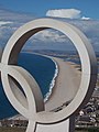
 "Spirit of Portland" Sculpture - geograph.org.uk - 2225095.jpg 640 × 480; 443 KB
-
 "Wreck" - geograph.org.uk - 4070381.jpg 640 × 480; 541 KB
-
 'Citadel' - Portland - geograph.org.uk - 5377119.jpg 640 × 480; 84 KB
-
 'The Court House', Castle Road - geograph.org.uk - 2779002.jpg 1,024 × 683; 138 KB
-
 18th century graffiti, St George Reforne - geograph.org.uk - 3102694.jpg 737 × 1,024; 378 KB
-
 80-G-252203 Normandy Invasion, June 1944.jpg 4,555 × 4,532; 3.29 MB
-

-
 A distant view of Chesil Beach - geograph.org.uk - 2136685.jpg 640 × 480; 105 KB
-
 A sighting of the tide race off Portland Bill - geograph.org.uk - 5904304.jpg 1,024 × 615; 921 KB
-
 A view looking down on Chiswell - geograph.org.uk - 6243940.jpg 4,608 × 3,456; 4.78 MB
-
 A View of Portland and one Red Arrow - geograph.org.uk - 2022046.jpg 1,024 × 682; 102 KB
-
 A wind turbine being erected - geograph.org.uk - 3453362.jpg 3,072 × 4,608; 5.5 MB
-
 A354 Portland Beach Road - geograph.org.uk - 5965096.jpg 1,024 × 684; 184 KB
-
 A354 Portland Beach Road - geograph.org.uk - 5965120.jpg 1,024 × 684; 160 KB
-
 A354 Portland Beach Road - geograph.org.uk - 5965129.jpg 1,024 × 684; 161 KB
-
 A354 Portland Beach Road - geograph.org.uk - 5965135.jpg 1,024 × 684; 175 KB
-
 A354 Portland Beach Road - geograph.org.uk - 5965140.jpg 1,024 × 684; 215 KB
-
 A354 towards Easton - geograph.org.uk - 5965083.jpg 1,024 × 684; 209 KB
-
 A354, Portland Beach Road - geograph.org.uk - 5419818.jpg 640 × 427; 312 KB
-
 Across the field to Southwell - geograph.org.uk - 2049852.jpg 1,024 × 682; 163 KB
-
 Across The Fleet - geograph.org.uk - 2021861.jpg 1,024 × 682; 157 KB
-
 Across The Fleet - geograph.org.uk - 5395802.jpg 1,200 × 900; 322 KB
-
 Across the Fleet to Chesil Beach - geograph.org.uk - 5423056.jpg 1,024 × 768; 100 KB
-
 Admiralty boundary stone - geograph.org.uk - 2781143.jpg 683 × 1,024; 242 KB
-
 Admiralty boundary stone ^29, New Road - geograph.org.uk - 2776129.jpg 683 × 1,024; 206 KB
-
 Admiralty Chart No 2620 Eddystone to Portland, Pubished 1880.jpg 16,235 × 11,031; 13.3 MB
-
 Admiralty Chart No 3315 Berry Head to Portland, Published 1954.jpg 18,262 × 11,044; 61.47 MB
-
 Admiralty Quarries - geograph.org.uk - 4154806.jpg 1,024 × 768; 154 KB
-
 Admiralty Quarries, stone moving - geograph.org.uk - 4154798.jpg 1,024 × 768; 99 KB
-
 Alessandria Hotel, ^71 Wakeham - geograph.org.uk - 3162125.jpg 1,024 × 683; 160 KB
-
 Alma Terrace - geograph.org.uk - 2547207.jpg 640 × 480; 304 KB
-
 Ammonite - geograph.org.uk - 4190537.jpg 640 × 640; 591 KB
-
 An Incomplete Arch^ - geograph.org.uk - 2039223.jpg 1,024 × 682; 226 KB
-
 Anchor near Leisure Centre, Portland, Dorset - geograph.org.uk - 2019398.jpg 1,024 × 768; 392 KB
-
 Apartment Block, Portland - geograph.org.uk - 2770227.jpg 4,288 × 3,216; 3.54 MB
-
 Apartment Block, Portland, Dorset - geograph.org.uk - 2019410.jpg 1,024 × 768; 212 KB
-
 Apartments, Portland, Dorset - geograph.org.uk - 2019418.jpg 1,024 × 768; 260 KB
-
 Archway by ruined church - geograph.org.uk - 3565874.jpg 640 × 480; 138 KB
-
-
 Artwork on edge of Bowers Quarry - geograph.org.uk - 3111882.jpg 1,024 × 683; 101 KB
-
 At Portland Bill - geograph.org.uk - 3909472.jpg 800 × 600; 89 KB
-
 At the top of Cheyne Weare Cliffs - geograph.org.uk - 2223152.jpg 640 × 427; 314 KB
-
 At the Tout Quarry Sculpture Park - geograph.org.uk - 6243058.jpg 4,608 × 3,456; 4.76 MB
-
 Atlantic House, Portland - geograph.org.uk - 5422744.jpg 1,024 × 768; 184 KB
-
 Avalanche Road towards Sweet Hill Road, Portland - geograph.org.uk - 4990213.jpg 1,600 × 1,065; 473 KB
-
 Avalanche Road, Southwell, Portland - geograph.org.uk - 4990194.jpg 1,600 × 1,065; 408 KB
-
 Avalanche Road, Southwell, Portland - geograph.org.uk - 4990197.jpg 1,600 × 1,065; 465 KB
-
 Back of Chesil Beach - geograph.org.uk - 2939735.jpg 640 × 480; 97 KB
-
 Badger in the Circle of Stones - geograph.org.uk - 4070350.jpg 640 × 480; 489 KB
-
 Beach House Tea Rooms ^ Hotel - geograph.org.uk - 4985014.jpg 1,600 × 1,065; 798 KB
-

-

-

-
 Beach huts near Portland Bill - geograph.org.uk - 5425843.jpg 4,000 × 3,000; 4.3 MB
-
 Beach huts near Portland Bill - geograph.org.uk - 5425846.jpg 4,000 × 3,000; 3.09 MB
-
 Beach huts on Portland Bill - geograph.org.uk - 6242213.jpg 1,024 × 683; 180 KB
-
 Beach huts, Church Ope Cove - geograph.org.uk - 3565871.jpg 640 × 480; 103 KB
-
 Beach Huts, Portland Bill - geograph.org.uk - 3614871.jpg 1,600 × 1,200; 407 KB
-
 Beach Huts, Portland Bill, Dorset - geograph.org.uk - 2019654.jpg 1,024 × 768; 228 KB
-
 Beach Huts, Portland Bill, Dorset - geograph.org.uk - 2019657.jpg 1,024 × 768; 327 KB
-
 Beached boats on the Fleet at dusk - geograph.org.uk - 2537423.jpg 640 × 480; 71 KB
-
 Belle View Terrace - geograph.org.uk - 2776110.jpg 1,024 × 683; 158 KB
-
 Bench on the clifftop - geograph.org.uk - 4052130.jpg 640 × 480; 431 KB
-
 Benchmark on 'Perryfield House', Weston Street - geograph.org.uk - 3161705.jpg 1,024 × 683; 210 KB
-
 Benchmark on 'The Court House', Castle Road - geograph.org.uk - 2779001.jpg 683 × 1,024; 154 KB
-
 Benchmark on All Saints Church - geograph.org.uk - 3162169.jpg 683 × 1,024; 240 KB
-
-
 Benchmark on Brackenbury School - geograph.org.uk - 2776038.jpg 683 × 1,024; 227 KB
-
 Benchmark on buttress of St Andrew's Church - geograph.org.uk - 3161443.jpg 683 × 1,024; 283 KB
-

-
 Benchmark on Castle Road wall - geograph.org.uk - 2709455.jpg 683 × 1,024; 313 KB
-
 Benchmark on corner pier of Alessandria Hotel - geograph.org.uk - 3162117.jpg 683 × 1,024; 191 KB
-
-
 Benchmark on garage, Victoria Square - geograph.org.uk - 2707766.jpg 683 × 1,024; 210 KB
-

-

-
 Benchmark on old gatepost on Southwell Road - geograph.org.uk - 3161671.jpg 683 × 1,024; 214 KB
-
 Benchmark on Osborne Hall, Queen's Road - geograph.org.uk - 2708616.jpg 683 × 1,024; 224 KB
-

-
 Benchmark on Petrel Lodge, Victoria Square - geograph.org.uk - 2707776.jpg 683 × 1,024; 174 KB
-
 Benchmark on Portland Museum building - geograph.org.uk - 3161767.jpg 683 × 1,024; 241 KB
-
 Benchmark on Portland Town Council Offices - geograph.org.uk - 2777776.jpg 683 × 1,024; 168 KB
-
 Benchmark on rock of Reap Lane wall - geograph.org.uk - 3161001.jpg 683 × 1,024; 344 KB
-
 Benchmark on the hall at St George's Centre - geograph.org.uk - 3163851.jpg 683 × 1,024; 190 KB
-
 Benchmark on the Methodist Chapel, Weston Street - geograph.org.uk - 3161490.jpg 683 × 1,024; 208 KB
-
 Benchmark on the Punchbowl Inn - geograph.org.uk - 3162525.jpg 683 × 1,024; 183 KB
-
 Benchmark on unit in Southwell Business Park - geograph.org.uk - 3160781.jpg 813 × 1,024; 145 KB
-
 Benchmark on Verne Yeates covered reservoir - geograph.org.uk - 3164195.jpg 683 × 1,024; 287 KB
-
 Benchmark on wall angle, Castle Road - geograph.org.uk - 2779004.jpg 683 × 1,024; 279 KB
-
 Benchmark on wall beside disused tramway - geograph.org.uk - 2779065.jpg 683 × 1,024; 280 KB
-

-
 Benchmark on wall of former building, Brandy Row - geograph.org.uk - 2783499.jpg 683 × 1,024; 248 KB
-
 Benchmark on wall of New Road - geograph.org.uk - 2779120.jpg 683 × 1,024; 286 KB
-
 Benchmark on wall of Old Hill - geograph.org.uk - 2780257.jpg 683 × 1,024; 251 KB
-
 Benchmark on wall of Old Hill - geograph.org.uk - 2780303.jpg 683 × 1,024; 296 KB
-
 Benchmark on wall post on Reforne - geograph.org.uk - 3163784.jpg 683 × 1,024; 237 KB
-
 Benchmark on ^1 Hambro Road, 'Freiheit' - geograph.org.uk - 2777867.jpg 683 × 1,024; 204 KB
-
 Benchmark on ^145 Avalanche Road - geograph.org.uk - 3161366.jpg 683 × 1,024; 195 KB
-
 Benchmark on ^2 Brymers Avenue - geograph.org.uk - 2777813.jpg 683 × 1,024; 190 KB
-
 Benchmark on ^27 Queens Road - geograph.org.uk - 2708602.jpg 683 × 1,024; 142 KB
-
 Benchmark on ^31 St Martin's Road - geograph.org.uk - 2777869.jpg 683 × 1,024; 252 KB
-
 Benchmark on ^49 Easton Street - geograph.org.uk - 3163304.jpg 683 × 1,024; 173 KB
-
 Benchmark on ^61 Avalanche Road - geograph.org.uk - 3161382.jpg 683 × 1,024; 307 KB
-
 Benchmark on ^83 Verne Common Road - geograph.org.uk - 2781168.jpg 683 × 1,024; 156 KB
-

-

-

-

-

-
 Bill of Portland, Trinity House flag - geograph.org.uk - 3643669.jpg 640 × 481; 41 KB
-
 Bill of Portland, two lighthouses - geograph.org.uk - 4746287.jpg 640 × 480; 37 KB
-

-

-
-
 Blocked gateway on Southwell Road - geograph.org.uk - 3161685.jpg 1,024 × 683; 264 KB
-

-

-
 Boatshed in the Evening - geograph.org.uk - 5802172.jpg 1,600 × 1,045; 452 KB
-

-
 Bowers Basebed and Jordans Basebed - geograph.org.uk - 4189483.jpg 640 × 416; 362 KB
-
 Bowers Roach - geograph.org.uk - 4189479.jpg 640 × 417; 385 KB
-
 Brick Houses on Church Lane - geograph.org.uk - 2222436.jpg 640 × 496; 410 KB
-

-
 Bridges over incline to Waycroft Quarries - geograph.org.uk - 2781098.jpg 1,024 × 683; 175 KB
-
 Broadcroft Quarry - geograph.org.uk - 4159850.jpg 640 × 427; 408 KB
-
 Broadcroft Quarry - geograph.org.uk - 4159863.jpg 640 × 427; 447 KB
-
 Broadcroft Quarry Portland Dorset 2.JPG 922 × 692; 293 KB
-
 Broadcroft Quarry Portland Dorset.JPG 922 × 692; 328 KB
-
 Building work at visitors centre - geograph.org.uk - 2939737.jpg 640 × 480; 82 KB
-
 Businesses by Portland Marina - geograph.org.uk - 5517437.jpg 640 × 480; 69 KB
-
 Cafe - Chesil Cove Portland - geograph.org.uk - 1941739.jpg 640 × 480; 68 KB
-
 Cafe - National Sailing Academy, Portland - geograph.org.uk - 4901997.jpg 1,024 × 827; 133 KB
-
-
 Castle Road and Admiralty^ building - geograph.org.uk - 2709467.jpg 1,024 × 683; 164 KB
-

-
 Caterpillars on Portland Bill - geograph.org.uk - 4989387.jpg 1,600 × 1,065; 472 KB
-
 Cattle on the steep slope of The Verne 1962 - geograph.org.uk - 2224568.jpg 2,592 × 1,680; 926 KB
-
 Causeway to Portland - geograph.org.uk - 5701858.jpg 640 × 427; 46 KB
-
 Cave Entrance^ - geograph.org.uk - 4190486.jpg 640 × 418; 380 KB
-
 Cave Hole, Portland, Dorset.jpg 1,024 × 768; 483 KB
-
 Caves near Cave Hole - geograph.org.uk - 3110519.jpg 1,024 × 683; 225 KB
-
 Caves under Quarries - geograph.org.uk - 4189620.jpg 640 × 422; 350 KB
-
 CEFAS Endeavour in Portland Port.jpg 958 × 539; 156 KB
-
 Cemetery from dockyard. Portland - geograph.org.uk - 3444387.jpg 3,264 × 2,448; 3.37 MB
-
 Charles Edward Dixon - The fleet at Portland, 1912.jpg 2,611 × 2,000; 562 KB
-
 Chesil Bank - geograph.org.uk - 4384649.jpg 1,024 × 768; 182 KB
-
 Chesil Bank - geograph.org.uk - 4384665.jpg 1,024 × 768; 193 KB
-
 Chesil Bank - geograph.org.uk - 4384774.jpg 1,024 × 754; 181 KB
-
 Chesil Bank, bench - geograph.org.uk - 4384670.jpg 1,024 × 768; 248 KB
-
 Chesil Bank, disused butts - geograph.org.uk - 4384417.jpg 1,024 × 768; 179 KB
-
 Chesil Bank, shed and bird hide - geograph.org.uk - 4384641.jpg 1,024 × 768; 172 KB
-
 Chesil Bank, shoreline - geograph.org.uk - 4384772.jpg 1,024 × 768; 176 KB
-
 Chesil Beach - geograph.org.uk - 2103376.jpg 1,728 × 1,152; 336 KB
-
 Chesil Beach - geograph.org.uk - 4434801.jpg 430 × 640; 61 KB
-
 Chesil Beach - geograph.org.uk - 6022586.jpg 1,024 × 768; 113 KB
-
 Chesil Beach and Chiswell - geograph.org.uk - 6243055.jpg 4,608 × 3,456; 4.9 MB
-
 Chesil Beach at Chiswell - geograph.org.uk - 6243033.jpg 4,608 × 3,456; 5.4 MB
-
 Chesil beach from Portland - geograph.org.uk - 2541113.jpg 640 × 480; 67 KB
-
 Chesil Beach from Portland - geograph.org.uk - 2541120.jpg 640 × 480; 67 KB
-
 Chesil Beach from Portland Bill - geograph.org.uk - 1974907.jpg 1,280 × 960; 516 KB
-
 Chesil Beach from Portland Heights - geograph.org.uk - 2770560.jpg 4,288 × 3,216; 2.13 MB
-
 Chesil Beach from the Heights - geograph.org.uk - 4187009.jpg 427 × 640; 356 KB
-
 Chesil Beach from Viewpoint - geograph.org.uk - 2541091.jpg 640 × 480; 82 KB
-
 Chesil Beach Holiday Park - geograph.org.uk - 2941649.jpg 640 × 480; 69 KB
-
 Chesil Beach in 1981 - geograph.org.uk - 3933718.jpg 1,024 × 819; 177 KB
-
-
 Chesil Beach, view from Portland - geograph.org.uk - 3643503.jpg 640 × 480; 47 KB
-

-
-
 Chesil Chippie - geograph.org.uk - 4985302.jpg 1,240 × 1,600; 460 KB
-
 Chesil Cove - geograph.org.uk - 6243037.jpg 4,608 × 3,456; 5.81 MB
-
 Chesil Cove - geograph.org.uk - 6243050.jpg 4,608 × 3,456; 4.9 MB
-
 Chesil Cove and Chesil Beach - geograph.org.uk - 6243048.jpg 4,608 × 3,456; 4.34 MB
-
 Chesil Cove from West Cliff, Portland - geograph.org.uk - 6429832.jpg 1,797 × 1,198; 421 KB
-
 Chesil Fleet at sunset (1) - geograph.org.uk - 2404543.jpg 1,600 × 1,200; 276 KB
-
 Chesil Fleet at sunset (2) - geograph.org.uk - 2404590.jpg 1,200 × 1,600; 259 KB
-
 Cheyne Weare - geograph.org.uk - 4069228.jpg 640 × 480; 66 KB
-
 Cheyne Weare - geograph.org.uk - 4069244.jpg 640 × 480; 56 KB
-
 Chiswell in early evening light - geograph.org.uk - 6245439.jpg 4,608 × 3,456; 3.89 MB
-
 Chiswell on the Isle of Portland - geograph.org.uk - 6243041.jpg 4,608 × 3,456; 4.68 MB
-
 Chlamys lamellosa - geograph.org.uk - 4189527.jpg 427 × 640; 424 KB
-
 Church Ope Cove - geograph.org.uk - 3565862.jpg 640 × 480; 83 KB
-
 Church Ope Cove - geograph.org.uk - 3565864.jpg 640 × 480; 83 KB
-
 Church Ope Cove - geograph.org.uk - 3565867.jpg 640 × 480; 62 KB
-
 Church Ope Cove - geograph.org.uk - 6243936.jpg 4,608 × 3,456; 4.72 MB
-
 Church Ope Cove - geograph.org.uk - 6517736.jpg 1,024 × 768; 158 KB
-
 Church Ope Cove, beach - geograph.org.uk - 3715640.jpg 1,024 × 751; 180 KB
-
 Church Ope Cove, Portland - geograph.org.uk - 3565857.jpg 640 × 480; 77 KB
-
 Cinnabar Moth (Tyria jacobaeae) - geograph.org.uk - 4189607.jpg 640 × 640; 498 KB
-
 Cirkel van Stenen - geograph.org.uk - 4187057.jpg 640 × 427; 431 KB
-
 Clear waters off Portland Bill - geograph.org.uk - 3565805.jpg 640 × 480; 105 KB
-
 Cliff at God Nore - geograph.org.uk - 2709192.jpg 640 × 428; 107 KB
-
 Cliff top, Portland, Dorset - geograph.org.uk - 2019695.jpg 1,024 × 768; 352 KB
-
 Cliff top, Portland, Dorset - geograph.org.uk - 2019699.jpg 1,024 × 768; 341 KB
-
 Cliff top, Portland, Dorset - geograph.org.uk - 2019704.jpg 1,024 × 768; 346 KB
-
 Cliff top, Portland, Dorset - geograph.org.uk - 2019708.jpg 1,024 × 768; 339 KB
-
 Cliff top, Portland, Dorset - geograph.org.uk - 2019709.jpg 1,024 × 768; 286 KB
-
 Cliff top, Portland, Dorset - geograph.org.uk - 2019716.jpg 1,024 × 768; 279 KB
-
 Cliff top, Portland, Dorset - geograph.org.uk - 2019729.jpg 1,024 × 768; 295 KB


_-_geograph.org.uk_-_2404543.jpg)
_-_geograph.org.uk_-_2404590.jpg)


_-_geograph.org.uk_-_4189607.jpg)


