Category:Protestantse Kerk (Warmond)
Jump to navigation
Jump to search
| Object location | | View all coordinates using: OpenStreetMap |
|---|
church building in Teylingen, Netherlands  | |||||
| Upload media | |||||
| Instance of | |||||
|---|---|---|---|---|---|
| Part of | |||||
| Location | Warmond, South Holland, Netherlands | ||||
| Street address |
| ||||
| Located on street |
| ||||
| Heritage designation |
| ||||
 | |||||
Nederlands: Hervormde Kerk - anno 1874
Kerk:
|
This is a category about rijksmonument number 521948
|
Twee bruggen met toegangshekken:
|
This is a category about rijksmonument number 525669
|
| Address |
|
Media in category "Protestantse Kerk (Warmond)"
The following 6 files are in this category, out of 6 total.
-
 Hek Nederlands Hervormde kerk, Warmond.JPG 2,048 × 3,072; 2.46 MB
-
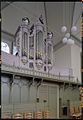 Interieur, aanzicht orgel - Warmond - 20369043 - RCE.jpg 833 × 1,200; 155 KB
-
 Kerk Warmond.jpg 8,000 × 6,000; 20.42 MB
-
 Overzicht westgevel met ingangspartij - Warmond - 20365865 - RCE.jpg 971 × 1,200; 394 KB
-
 Warmond, kerk2 2007-04-18 12.19.JPG 1,704 × 2,272; 2.56 MB
-
 Warmond, Netherlands - panoramio (3).jpg 4,128 × 3,096; 4.68 MB


.jpg)