Category:Provoost, Brielle
Jump to navigation
Jump to search
| Object location | | View all coordinates using: OpenStreetMap |
|---|
 | |||||
| Upload media | |||||
| Instance of | |||||
|---|---|---|---|---|---|
| Location | Brielle, Voorne aan Zee, South Holland, Netherlands | ||||
| Street address |
| ||||
| Located on street |
| ||||
| Heritage designation |
| ||||
 | |||||
|
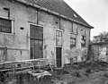
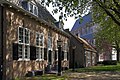
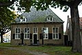
This is a category about rijksmonument number 10648
|
| Address |
|
Media in category "Provoost, Brielle"
The following 33 files are in this category, out of 33 total.
-
 Binnenplaats met achtergevel van de voorvleugel - Brielle - 20042818 - RCE.jpg 1,200 × 951; 252 KB
-
 Brielle, Netherlands - panoramio (3).jpg 4,896 × 3,264; 6.55 MB
-

-

-
-
 Exterieur OVERZICHT - Brielle - 20309625 - RCE.jpg 1,200 × 1,200; 395 KB
-
 Interieur hal voorvleugel - Brielle - 20042816 - RCE.jpg 1,200 × 954; 185 KB
-
 Interieur hal voorvleugel - Brielle - 20042833 - RCE.jpg 937 × 1,200; 131 KB
-
 Interieur linker voorkamer voorvleugel - Brielle - 20042815 - RCE.jpg 958 × 1,200; 191 KB
-
 Interieur rechter voorkamer voorvleugel - Brielle - 20042822 - RCE.jpg 1,200 × 951; 164 KB
-
 Interieur zolder - Brielle - 20042826 - RCE.jpg 1,200 × 955; 213 KB
-
 Interieur zolder - Brielle - 20042827 - RCE.jpg 1,200 × 955; 219 KB
-

-
 Militair.jpg 1,500 × 999; 754 KB
-
 Overzicht achterzijde Provoost - Brielle - 20042808 - RCE.jpg 1,194 × 1,200; 322 KB
-
 Overzicht binnenplaats Provoost - Brielle - 20042824 - RCE.jpg 1,200 × 957; 201 KB
-
 Overzicht binnenplaats Provoost - Brielle - 20042829 - RCE.jpg 1,200 × 969; 275 KB
-

-

-
 Overzicht linker zijgevel - Brielle - 20042831 - RCE.jpg 1,200 × 946; 283 KB
-
 Overzicht linkerzijde en voorgevel - Brielle - 20042820 - RCE.jpg 1,200 × 958; 262 KB
-
 Overzicht linkerzijde Provoost - Brielle - 20042807 - RCE.jpg 1,187 × 1,200; 349 KB
-

-
 Overzicht omgeving Provoost - Brielle - 20042823 - RCE.jpg 1,200 × 955; 318 KB
-
 Overzicht omgeving Provoost - Brielle - 20042828 - RCE.jpg 1,200 × 960; 211 KB
-
 Overzicht Provoost schiun van de achterzijde - Brielle - 20042806 - RCE.jpg 1,197 × 1,200; 351 KB
-

-
 Overzicht rechterzijde en achtergevel - Brielle - 20042821 - RCE.jpg 1,200 × 960; 243 KB
-
 Overzicht voor- en linker zijgevel - Brielle - 20042830 - RCE.jpg 1,200 × 953; 355 KB
-
 Overzicht voorzijde - Brielle - 20042819 - RCE.jpg 1,200 × 954; 324 KB
-
 Overzicht voorzijde Provoost - Brielle - 20042810 - RCE.jpg 1,197 × 1,200; 397 KB
-
 Provoost (3166246453).jpg 1,024 × 685; 330 KB
-
 Voorgevel - Brielle - 20042825 - RCE.jpg 1,200 × 963; 272 KB

.jpg)


.jpg)
