Category:Putterstraat 42, Heusden
Jump to navigation
Jump to search
| Object location | | View all coordinates using: OpenStreetMap |
|---|
building in Heusden, Netherlands  | |||||
| Upload media | |||||
| Instance of | |||||
|---|---|---|---|---|---|
| Location | Heusden, North Brabant, Netherlands | ||||
| Street address |
| ||||
| Located on street | |||||
| Heritage designation |
| ||||
 | |||||
|
This is a category about rijksmonument number 22084
|
| Address |
|
Media in category "Putterstraat 42, Heusden"
The following 6 files are in this category, out of 6 total.
-
 Detail voorgevel, beeldhouwwerk - Heusden - 20112112 - RCE.jpg 893 × 1,200; 193 KB
-
 Deur - Heusden - 20112113 - RCE.jpg 1,185 × 1,200; 310 KB
-
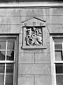
 Gevelsteen - Heusden - 20112114 - RCE.jpg 824 × 1,200; 181 KB
-
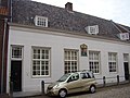 Putterstraat 42 Heusden.JPG 3,264 × 2,448; 2.16 MB
-
 Schuttersdoelen P1060624.JPG 3,264 × 2,448; 3.74 MB
-
 Voorgevel - Heusden - 20112111 - RCE.jpg 1,200 × 806; 213 KB


