Category:RAF Staverton
Jump to navigation
Jump to search
English: The former RAF airfield RAF Staverton near Staverton, Gloucestershire, England is now the site of Gloucestershire Airport.
| Object location | | View all coordinates using: OpenStreetMap |
|---|
Former RAF base, Gloucestershire  | |||||
| Upload media | |||||
| Instance of |
| ||||
|---|---|---|---|---|---|
| Location | |||||
| Operator | |||||
| Inception |
| ||||
| Dissolved, abolished or demolished date |
| ||||
| Elevation above sea level |
| ||||
 | |||||
Media in category "RAF Staverton"
The following 2 files are in this category, out of 2 total.
-
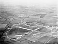 Staverton aerodrome aerial photograph 1941 IWM MH 26559.jpg 800 × 612; 68 KB
-

