Category:Raadhuis (Broek in Waterland)
Jump to navigation
Jump to search
| Object location | | View all coordinates using: OpenStreetMap |
|---|
 | |||||
| Upload media | |||||
| Instance of | |||||
|---|---|---|---|---|---|
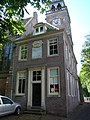
| Location | Broek in Waterland, Broek in Waterland | ||||
| Street address |
| ||||
| Located on street |
| ||||
| Heritage designation |
| ||||
 | |||||
|
This is a category about rijksmonument number 11060
|
| Address |
|
Media in category "Raadhuis (Broek in Waterland)"
The following 3 files are in this category, out of 3 total.
-
 Broek in waterland Leeteinde 2.JPG 2,448 × 3,264; 1.99 MB
-

-
 Leeteinde 2.JPG 1,944 × 2,592; 1,008 KB

