Category:Radio propagation
Sari la navigare
Sari la căutare
behavior of radio waves as they travel, or are propagated, from one point to another, or into various parts of the atmosphere  | |||||
| Încarcă multimedia | |||||
| Subclasă a | |||||
|---|---|---|---|---|---|
| |||||
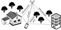
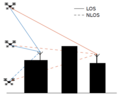
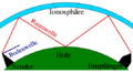
Files regarding the propagation of en:radio frequencies.
Subcategorii
Această categorie conține următoarele 8 subcategorii, dintr-un total de 8.
B
E
F
I
M
Q
S
T
Fișiere media din categoria „Radio propagation”
Următoarele 133 fișiere se află în această categorie, dintr-un total de 133.
-
 10log x and x.svg 214x433; 10 KB
-
 2-ray ground reflected Power vs distance.jpg 1.200x900; 48 KB
-
 3D Ionospheric Ray Example.png 657x513; 27 KB
-
 811 10th Av antenna tower jeh.jpg 2.251x3.265; 882 KB
-
 A2g channel.png 1.210x590; 97 KB
-
 A2G param.png 916x723; 84 KB
-
 Alcance-enlace-duas-antenas-pt.png 218x181; 3 KB
-
 Amplifier combiner splitter network.svg 2.903x1.854; 120 KB
-
 Atmosphericnoise.PNG 792x622; 103 KB
-
 Attenuation.jpg 1.169x1.627; 716 KB
-
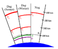
 Bodenwelle Raumwelle.png 537x297; 5 KB
-
 Boswell Bay White Alice Communications System site.jpg 4.701x3.704; 3,61 MB
-
 Bypass Switch Application.png 585x619; 14 KB
-
 Chambre-anechoique.jpg 300x299; 25 KB
-
 Circuit ondes de sol.svg 381x360; 113 KB
-
 Circuit ondes réfléchies.svg 381x195; 114 KB
-
 CochannelTVI.png 1.208x540; 8 KB
-

-
 Coverage map for WQUB-FM HD1.jpg 1.056x1.155; 919 KB
-
 CriticalFrequency-NPS.png 400x200; 12 KB
-
 Cylindrical cavity.svg 340x230; 8 KB
-
 Diagrama EH.JPG 640x577; 61 KB
-
 DifferentFrequencies-NPS.png 400x200; 14 KB
-
 DifferentTransmissionAngles-NPS.png 400x200; 16 KB
-
 Earthbulge.jpg 207x198; 13 KB
-
 Feluleti hullámterjedés.png 800x433; 56 KB
-
 Figira 4. Vista lateral de dos rayos.svg 780x709; 103 KB
-
 Figura 1. Top view same height.svg 531x319; 142 KB
-
 Figura 1. Vista superior de 10 rayos.svg 638x709; 64 KB
-
 Figura 1. vistasuperiorigualaltura.svg 531x319; 138 KB
-
 Figura 2. Radio Enlace Grafica I.svg 746x606; 100 KB
-
 Figura 2. Vista lateral.svg 744x709; 69 KB
-
 Figura 3. lateralalturasiguales.svg 612x563; 59 KB
-
 Figura 3. Modelamiento del rayo.svg 638x531; 80 KB
-
 Figura 4. lateralalturasigualesconpared.svg 602x602; 73 KB
-
 Figura 5.lateral alturas diferentes.svg 602x422; 109 KB
-
 Figura 6.lateralalturasdiferentes.svg 638x744; 172 KB
-
 Figure 1. Top view of 10 rays.svg 638x709; 64 KB
-
 Figure 2. Radio Link Graphic.svg 746x606; 96 KB
-
 Figure 2. Top view of 10 rays.svg 744x709; 69 KB
-
 Figure 3. Lateral heights equal.svg 612x563; 59 KB
-
 Figure 3. Side view of two rays.svg 638x531; 80 KB
-
 Figure 4. Side view of two transmitted.svg 780x709; 106 KB
-
 Figure 5. Lateral heights different.svg 602x422; 109 KB
-
 Figure 5. Lateral heights equal wall.svg 602x602; 73 KB
-
 Figure 6. Lateral different heights.svg 638x744; 169 KB
-
 FlareNPS.gif 400x200; 14 KB
-
 Formula 1.png 488x344; 46 KB
-
 Free-space path loss plot.svg 720x540; 730 KB
-
 Fresnelsche zone.gif 380x180; 4 KB
-
 FresnelSVG.svg 800x400; 24 KB
-
 FSPL 100 MHz - 6 GHz.svg 720x540; 917 KB
-
 FSPL for common 802.11 frequency bands.svg 512x425; 1 KB
-
 Gostingsignal.jpg 354x282; 13 KB
-
 Grafica 1 lim.svg 638x709; 56 KB
-
 Grafica 1 Vista superior de 10 rayos.svg 638x709; 101 KB
-
 Grafica 2 ingles.svg 638x709; 40 KB
-
 Grafica 2 lim.svg 638x709; 40 KB
-
 Grafica 3 me ingles.svg 780x709; 86 KB
-
 Grafica 3 me.svg 780x709; 86 KB
-
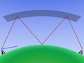
 Groud Wave Propagation.svg 103x57; 75 KB
-
 Hathaway Cycle 24 Prediction.png 2.048x1.536; 342 KB
-
 Horizontxxx.jpg 463x237; 16 KB
-
 IncidentAngle-NPS.gif 400x200; 14 KB
-
 Ionensturm-Voraussage.jpg 1.024x413; 113 KB
-
 Ionosfeer Refleksie.png 472x396; 11 KB
-
 Ionosphere MUF.png 653x434; 45 KB
-
 IonosphereMUF.png 1.194x638; 70 KB
-
 IonosphereMUF.svg 1.194x638; 13 KB
-
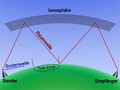
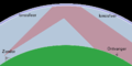
 Ionospheric reflection (IT).svg 461x346; 17 KB
-
 Ionospheric reflection german deadzone.png 492x369; 103 KB
-
 Ionospheric reflection german.png 1.024x768; 171 KB
-
 Ionospheric reflection-de.svg 500x350; 3 KB
-
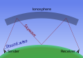
 Ionospheric reflection.png 1.024x768; 145 KB
-
 Ionospheric reflection.svg 461x346; 14 KB
-
 Ionospheric reflectionDay and Night.PNG 653x376; 14 KB
-
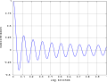 Jakes rayleigh autocorr 10Hz doppler.svg 800x612; 42 KB
-
 Kort golf.png 400x200; 4 KB
-
 Lancer de rayons.JPG 730x472; 44 KB
-
 Line of sight mw transmission.svg 814x354; 18 KB
-
 Longrangetransmission.png 606x267; 4 KB
-
 Maison antenne plan.jpg 1.190x1.683; 809 KB
-
 Material cavity.JPG 1.081x660; 33 KB
-
 Meteor Burst SNOTEL.jpg 590x400; 26 KB
-
 Modelo Walfish y Bertoni.png 1.103x378; 58 KB
-
 MS-50MHz.png 703x119; 66 KB
-
 MultipathTVghost.png 1.042x516; 3 KB
-
 NUEVA (ingles).svg 638x709; 33 KB
-
 Odbicie fal od jonosfery.svg 2.048x1.024; 8 KB
-
 Pacific Scatter.jpg 575x368; 52 KB
-
 Propagación por onda ionosférica (IT).svg 455x271; 18 KB
-
 Propagación por onda ionosférica.svg 455x271; 16 KB
-
 Propagation ondes moyenne.PNG 923x522; 434 KB
-
 Propagation ondes électromagnétiques.svg 787x318; 16 KB
-
 Propagation VHF.PNG 1.275x549; 941 KB
-
 QRP HF Coverage 1W vs 99W.png 638x720; 270 KB
-
 Radio propagation noise.jpg 1.188x828; 370 KB
-
 RadioLuxemburgEffect-Map.jpg 1.134x1.116; 142 KB
-
 Rauten.png 606x745; 231 KB
-
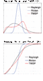
 Rayleigh Doppler PSD 10Hz.svg 800x665; 49 KB
-
 Rayleigh fading doppler 100Hz.svg 800x627; 44 KB
-
 Rayleigh fading doppler 10Hz.svg 806x635; 40 KB
-
 Rebotghosting.jpg 800x600; 96 KB
-
 Rectangular cavity.JPG 1.086x659; 33 KB
-
 Reflection co-efficient ground reflection of radio waves.jpg 1.200x900; 44 KB
-
 Repeater-schema.png 306x206; 23 KB
-
 Repeater-schema.svg 341x245; 7 KB
-
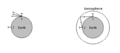
 Satellite Footprint.png 1.237x1.247; 97 KB
-
 ShortWaveFadeNOAA.png 456x513; 34 KB
-
 Skip Zone Example.gif 645x530; 29 KB
-
 Sky Wave Propagation.svg 227x227; 14 KB
-
 Solar-cycle-data-ca.svg 868x578; 90 KB
-
 Solar-cycle-data.png 700x466; 37 KB
-
 SporadicE-NPS.gif 400x200; 13 KB
-
 SpreadF-NPS.gif 400x200; 13 KB
-
 Surface Wave Propagation.jpg 2.728x1.028; 432 KB
-
 TabelareflexaoAAL.JPG 680x1.211; 75 KB
-
 TransmissionAngle-NPS.gif 400x200; 14 KB
-
 Tropospheric scatter.jpg 902x661; 184 KB
-
 TWDP Example.gif 1.906x3.187; 144 KB
-
 TWDP Example2.gif 1.868x3.475; 142 KB
-
 TWDP Example3.gif 1.868x3.475; 163 KB
-
 Two ray ground reflected model.svg 1.080x810; 100 KB
-
 Uplink y Downlink.jpg 373x218; 18 KB
-
 Uplinkdownpp.svg 650x470; 88 KB
-
 US ground conductivity map.webp 11.671x3.223; 114,39 MB
-
 VHF propagation.png 2.229x1.110; 250 KB
-
 Visada-antena-pt.png 220x189; 3 KB
-
 VOACAP HF propagation p2p.jpeg 400x357; 29 KB
-
 VOACAP HF propagation prediction.jpeg 400x197; 22 KB
-
 WQUB Contour Map.gif 700x700; 52 KB
-
YleisradioBodensee01.ogg 1 min 3 s; 772 KB
-
 Zweiwegeausbreitung.svg 1.052x744; 8 KB


.png)


.svg)


.svg)


.svg)


